2010 Chile earthquake
| ||||||||||||||


The 2010 Chile earthquake occurred off the coast of the Maule Region of Chile, on February 27, 2010, at 03:34 local time (06:34 UTC), rating a magnitude of 8.8 on the moment magnitude scale and lasting about three minutes. The cities experiencing the strongest shaking — IX (Ruinous) on the Mercalli intensity scale — were Talcahuano, Arauco, Lota, Chiguayante, Cañete, Talca, Concepción, and San Antonio. The earthquake was felt in the capital Santiago at Mercalli intensity scale VIII (Destructive).
- The preceding is a contiguous excerpt from the introduction of "Wikipedia:2010 Chile earthquake"; references and wikilinks have been stripped from the original and new wikilinks related to OpenStreetMap have been added. For supporting references, refer to the Wikipedia source.
2010 Pichilemu earthquake
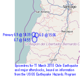
A 6.9 magnitude earthquake occurred on March 11, 2010, 40 kilometers southwest from Pichilemu, O'Higgins Region, Chile. (...) The place most affected by the earthquake was Pichilemu, the epicentre of the earthquake. It destroyed Ross Park, most of the Ross Casino and many houses in Espinillo and Rodeíllo.
- The preceding is a non-contiguous excerpt from "Wikipedia:2010 Pichilemu earthquake"; references and wikilinks have been stripped from the original and replaced with OSM-related links. For supporting references, see the Wikipedia source.
Resources
In addition to material contained in child pages to this page, please see...
- WikiProject Chile: The Chilean OpenStreetMap community have previously produced great maps of the area.
- CrisisCommons wiki page
- Ushahidi site for Chile Earthquake and Tsunami Affected Countries
- Crisismappers Google Group and a special Group for Chile
- Form to add Media sources ( read-only Google spreadsheet)
- Media Monitoring Group
- Talk-cl -- OpenStreetMap Chile, for OpenStreetMap e-mail discussion related to Chile.
- HOT -- Humanitarian OpenStreetMap Team, for OpenStreetMap e-mail discussion related to humanitarian action, during crises and for readiness.
Use and references
- Delta State Map Books
- UN-SPIDER portal
- G-MOSAIC Project Free maps and datasets for download