<20MB, <512MB, <2GB Maps
(Redirected from 20MB, 512MB, 2GB Maps)
Jump to navigation
Jump to search
| Unmaintained. This app does not exist anymore. |
| <20MB, <512MB, <2GB Maps | ||||||||||||||||||||||||||||||||||||||||||||||||||||||||||||||||||||||||||||||||||||||||||||||||||||||||||||||||||||||||
|---|---|---|---|---|---|---|---|---|---|---|---|---|---|---|---|---|---|---|---|---|---|---|---|---|---|---|---|---|---|---|---|---|---|---|---|---|---|---|---|---|---|---|---|---|---|---|---|---|---|---|---|---|---|---|---|---|---|---|---|---|---|---|---|---|---|---|---|---|---|---|---|---|---|---|---|---|---|---|---|---|---|---|---|---|---|---|---|---|---|---|---|---|---|---|---|---|---|---|---|---|---|---|---|---|---|---|---|---|---|---|---|---|---|---|---|---|---|---|---|---|
 | ||||||||||||||||||||||||||||||||||||||||||||||||||||||||||||||||||||||||||||||||||||||||||||||||||||||||||||||||||||||||
| Author: | Games for Little Timmy Software Inc. | |||||||||||||||||||||||||||||||||||||||||||||||||||||||||||||||||||||||||||||||||||||||||||||||||||||||||||||||||||||||
| License: | Proprietary (1,59€) | |||||||||||||||||||||||||||||||||||||||||||||||||||||||||||||||||||||||||||||||||||||||||||||||||||||||||||||||||||||||
| Status: | Broken | |||||||||||||||||||||||||||||||||||||||||||||||||||||||||||||||||||||||||||||||||||||||||||||||||||||||||||||||||||||||
| Version: | 1.7.1 (2012-07-01) | |||||||||||||||||||||||||||||||||||||||||||||||||||||||||||||||||||||||||||||||||||||||||||||||||||||||||||||||||||||||
| Language: | English
| |||||||||||||||||||||||||||||||||||||||||||||||||||||||||||||||||||||||||||||||||||||||||||||||||||||||||||||||||||||||
| Website: | http://www.GamesforLittleTimmy.com | |||||||||||||||||||||||||||||||||||||||||||||||||||||||||||||||||||||||||||||||||||||||||||||||||||||||||||||||||||||||
|
Offline maps and POIs for entire countries as well as selected cities. |
||||||||||||||||||||||||||||||||||||||||||||||||||||||||||||||||||||||||||||||||||||||||||||||||||||||||||||||||||||||||
| ||||||||||||||||||||||||||||||||||||||||||||||||||||||||||||||||||||||||||||||||||||||||||||||||||||||||||||||||||||||||
<20MB, <512MB, <2GB Maps are city and country specific maps for the iPhone, iPod touch and iPad. They store OpenStreetMap data in vector format and draw the maps as needed. Because the map content is stored in a compressed binary format, very large areas can be stored inside of the application.
Features
- Street titles move to keep them on the map when you zoom or move.
- Points of Interest fade in as the user zooms to prevent the map form being too cluttered.
- Internal places database has precomputed "Is In" data - cities know which states they are in making selection easier.
- Additional map data downloads for free (does not hit OSM servers).
Gallery

Places Database in the <2GB Germany Application.
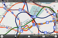
Transit Maps View <20MB Hamburg Application.
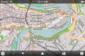
City View in <512MB Switzerland Application.
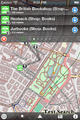
Text Search in <512MB Austria Application.


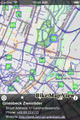
Bike Map View in the <20MB Munich Application.
