AT5-OpenSeaMap-Chart for Lowrance Simrad B&G

|
Here you can download OpenSeaMap-charts in AT5-format.
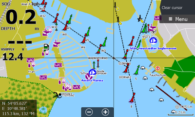
AT5-charts work with seachart-plotters from Lowrance, Simrad and B&G. It is also possible to use them with Insight Planner which is a tool for marine navigation .
Disclaimer
Not to be used for navigation. Users should be aware that the available data is sometimes defective and/or incomplete. OpenSeaMap is for use with other charts and can not replace official charts. Use is at your own risk.
Combination
The structure of the charts is modular which enables compositions of any desired areas and combinations with other charts.
Seamarks
Global map with almost all seamarks from the OSM database.
Coastal Waters
Blue colored coastal waters of the respective areas.
Land Area
Land areas of whole continents or (depending on the size) smaler subregions.
Depth Areas
Work in progress. You can support us with your sonar logs!
Just select “Log Sonar” in the sonar settings during your trip and upload the .sl2 or .sl3 files from your SD card to https://depth.openseamap.org
Hints for the download
Atlas version 10, 12 or 13?
Higher Atlas versions enable more features. Choose the highest possible version for your device. See "List of devices" below.
You can find the versions as v10, v12 and v13 in the download section below.
Coverage
You can display the coverage of the regions and subregions when you click on the "coverage" next to the name.
Combination
Combine the modular charts from left to right. You will need to download the Seamarks, Coastal Waters and Land Area for your desired area.
Remember to select the highest Atlas version which is compatible with your device per row and column. See "Atlas version" above.
Example download for Florida:
Seamarks + Coastal Waters “North America” + Land Area “US South”
Updates
The charts are updated twice a month. The process starts at the first and third monday of the month and takes up to four days including the synchronisation to the FTP server.
Download
Chart installation
The download is in form of a ZIP file. Unpack all files on an SD card.
Be aware: Some devices expect the files in the root directory. But some devices support subdirectorys. See "List of devices".
Device settings
The right map type has to be chosen in the map menu. Depending on the device "Lowrance", "Insight" or "OpenSeaMap" is the right setting.
Usually you can find the selection menu in the chart options. See manual of the respective plotter.
List of devices
Everything we know about the peculiarities of the devices can be found in this list.
coverage If a type of device is missing, we don't have information about it yet. coverage If a cell is empty, we don't have this information yet. coverage If you found something out: Write us, and we will amend it! coverage ... or even better: Fill it in here yourself.
Meaning of the columns
| Atlas version: | Maximum compatible Atlas version. |
|---|---|
| SD size: | Maximum size of the SD card in GB |
| Root: | Yes: Files have to lie in the root directory. No: Files may lie in a subdirectory. |
| Name: | The file name can only have a maximum of 8 or 16 characters before the file extension. |
Lowrance
| Device type | Atlas version | SD size | Root | Name | Remarks |
|---|---|---|---|---|---|
| Elite | 10 | ||||
| Elite Chirp | 12 | 32 GB | No | ||
| Elite HDI | 10 | 32 GB | |||
| Elite 5 HDI | 10 | No | 1 GB SD used | ||
| Elite Ti | 13 | 32 GB | No | ||
| HDS Gen1 | 12 | 32 GB | No | ||
| HDS Gen2, Gen3, Carbon | 13 | 64 GB | No | ||
| Hook | 13 | ||||
| LMS-332 | Yes | ||||
| Mark | 10 | ||||
| Mark-4 HDI | 10 | 8 GB | No | Thus far unable to load > 1 map simultaneously |
Simrad
| Device type | Atlas version | SD size | Root | Name | Remarks |
|---|---|---|---|---|---|
| NSS12 | Yes | ||||
| NSS7 EVO2 | 13 | 16gb | Yes | ||
| GO7 XSE | 13 | 16 GB | Yes | ||
| GO7 XSR | 13 |
B&G
| Device type | Atlas version | SD size | Root | Name | Remarks |
|---|---|---|---|---|---|
| Vulcan 5 FS | 13 | No | |||
| Vulcan 7 FS | 13 | 32 GB | Yes | ||
| Zeus 12 | Yes | Yes | No map version displays. V10 map crashes the Zeus. V12 Seamarks works. | ||
| Zeus2 W7 | 13 | Yes | No | Used a 16 GB card | |
| Zeus T7 | 12 |
Support, Feedback and improvement suggestions
Please use the OpenSeaMap Forum: https://forum.openseamap.org/viewforum.php?id=11
Sources
The data originates from OpenSeaMap and OpenStreetMap.
Map creation via https://openseamap.org/ by Sven Schönhoff https://schoenhoff.org
