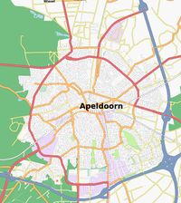
Apeldoorn
Jump to navigation
Jump to search
| V・T・E |
| latitude: 52.211, longitude: 5.965 |
| Browse map of Apeldoorn 52°12′39.60″ N, 5°57′54.00″ E |
| Edit map |

|
|
External links:
|
| Use this template for your locality |
Apeldoorn is a Town in Gelderland at latitude 52°12′39.60″ North, longitude 5°57′54.00″ East.
Description
Apeldoorn is a city and municipality with 150.000 inhabitants, it is situated on the eastern edge of the largest lowland nature area in North Western Europe: the Veluwe.
Apeldoorn is known for it's royal palace Het Loo, the monkey zoo Apenheul, a large insurance company and the Dutch tax administration.
Suburbs
- Brouwersmolen
- Componistenkwartier
- De Maten
- Malkenschoten
- Metaalbuurt
- Rivierenkwartier
- Ugchelen
- West
- Westenenk
Municipally
Villages
- Beekbergen
- Hoenderloo
- Hoog Soeren
- Klarenbeek
- Lieren
- Loenen
- Oosterhuizen
- Uddel
- Ugchelen
Hamlets
- Assel
- Beemte-Broekland
- Engeland
- Groenendaal
- Hooilanden
- Nieuw-Milligen
- Radio Kootwijk
- Wenum-Wiesel
- Woudhuizen
- Woeste Hoeve
ToDo
Major stuff to do:
City
- Footways & cycleways in parks (Oranjepark, Mheenpark, Matenpark).
- Completing and correcting the road network from AND (which is old).
- Adding POI (car/cycle parking, shops, landmarks, etc.).
Municipally
- Forest tracks on the Veluwe.
- Completing and correcting the road network from AND (which is old).
- Cycle ways.
- Cycle node network.
Users
The following users are involved in mapping Apeldoorn:
