Australian Tagging Guidelines/Roads
Overview
The mapping of Australian roads is broadly consistent with the global guidelines in OpenStreetMap. This page provides supplementary guidance specific to Australia and its unique infrastructure.
Road Hierarchy
The implementation of highway=* classifications varies significantly from country to country. The standard practice in Australia is generally consistent with the global definition, and the examples below can help contextualise the application of this hierarchy for local mappers.
There is no direct correlation between the road classification and route numbers. The classifications provided below are a guide, but mappers should classify highways based on the actual nature of the road, rather than any formal route designation.
| Tag | Rendering | Classification | Description | Example | ||
|---|---|---|---|---|---|---|
| highway=motorway |  |
M roads PD (WA) |
Motorways, freeways, and freeway-standard roads. | Urban | The metropolitan motorway/freeway network. | M4 Western Motorway, Greater Sydney |
| Rural | Generally will be divided roads with at least 2 lanes in each direction, 100km/h+ speed limit, limited access via interchanges, and no traffic lights. | Federal Highway (M23), New South Wales | ||||
| highway=trunk |  |
A roads M (Non-Fwy) PD/RD (WA) NH |
The next-most important roads. Major highways, trunk routes spanning connecting population centres. | Urban | Major highways and cross-city roads that don't qualify as a motorway. | Canning Highway, Greater Perth |
| Rural | Important highways connecting major population centres. | Landsborough Highway, Western Queensland | ||||
| highway=primary |  |
B roads
Other State Roads |
The next-most important roads. Major connecting roads and highways. | Urban | Other cross-city routes and arterial roads.
State roads that are not Class A roads in some metropolitan areas (except transit ways). |
Tiger Brennan Drive, Darwin |
| Rural | State maintained roads connecting major population centres and the trunk network. | The Outback Highway, South Australia | ||||
| highway=secondary |  |
C roads
Regional Roads (NSW) |
The next-most important roads. | Urban | Major roads within a local area, often connecting neighbouring suburbs. | Invermay Road, Invermay |
| Rural | Roads providing links to smaller population centres and the primary network. | Wallabadah Road, Quirindi | ||||
| highway=tertiary |  |
D roads Collector Roads Distributor B/Local Distributor (WA) |
The next-most important roads. | Urban | Minor through roads and routes within a local area. Often act as feeders to residential streets and are managed by local councils. | Skye Road, Frankston |
| Rural | Roads providing links towns, villages, points of interest. | Springs Road, Kangaroo Island | ||||
| highway=unclassified |  |
Industrial Roads (WA) | Minor roads that are neither tertiary or residential roads. Not generally through routes. | Urban | Other streets. | Lawrence Hargrave Way, Parafield |
| Rural | Other named minor roads. | Ruwolts Road, Boomanoomana | ||||
| highway=residential |  |
Access Roads (WA) | Residential and other local streets. | Urban | Residential Streets. | Wayfarer Avenue, Mermaid Waters |
| Rural | Local streets in and around towns and rural areas. | Gurney Way, Eucla | ||||
| highway=service |  |
Service and access roads | Urban | Service and access roads. Also used for small rear-access lanes. | Lennox Crossing, Acton | |
| Rural | Same as urban. | Toms Ridge Road, Christmas Island | ||||
| highway=track |  |
Service and access roads that aren't part of the general road network. Generally not paved, often not public access for vehicles. | Urban | Unpaved access tracks and paths in urban parklands, fire tracks, etc. | Blackbutt West Firetrail, Blackbutt | |
| Rural | Fire trails, forest drives, 4WD tracks, and similar roads. | Telephone Swamp Road, Tibooburra | ||||
Other Roads
| Tag | Rendering | Description | Example | Image | |||
|---|---|---|---|---|---|---|---|
| highway=living_street |  |
A "shared zone" thoroughfare with low speed limits (often 10-20km/h) where pedestrian traffic is given higher priority over vehicles. Often used on major pedestrian shopping roads or where pedestrians may cross the road unexpectedly. Does not include "shared zone" parking aisles/driveways: use designation=shared_zone. |
Wells Street, Redfern |
||||
| highway=* designation=shared_zone |
"Shared Zone" (signage) roads that do not qualify as a living street, such as "shared zone" parking aisles and driveways.. | Redcliffe Parade, Redcliffe |

| ||||
| Pipestems |
| ||||||
Re pipestem discussions see talk-au Sept 21, Mar 22, https://wiki.openstreetmap.org/wiki/Talk:Tag:service%3Ddriveway#Pipestems
Possible indicators of shared driveways vs streets include:
named streets,
house numbers,
rubbish collection location,
road markings,
sign posts,
footpaths,
nature strips
streetlights
letter box locations
breaks the kerb with a ramp or level
has a kerb
private or public land
maintained by government or owners
part of the public road network
access control: gates and signage
Road Details
Surface and Road Seal
Australia is the sixth largest country by area in the world and is one of the most sparsely populated. Australia's population is heavily concentrated on the coast, and the interior of the country is dominated by harsh, unforgiving terrain. Construction and maintenance of paved roads in profoundly remote areas is both impractical and uneconomical, and some outback highways are challenging roads only navigable by certain vehicles. Due to the highly variable standard of maintenance of roads in Australia the classification of a road cannot be used to infer the type of road surface. The surface=* tag should be added to roads wherever possible, particularly in regional and rural areas, for this reason.
Road Quality and 4WD-only roads

|
This section of the guidelines is controversial. Join the discussion |
The Australian usage of the term "![]() four-wheel drive" (4WD) has caused confusion for international mappers in the past, who may be more familiar with terms such as "
four-wheel drive" (4WD) has caused confusion for international mappers in the past, who may be more familiar with terms such as "![]() off road vehicle".
off road vehicle".
The tracktype=* tag can be used to denote the navigability of an unsealed road. In addition to the documented, globally accepted values grade1—grade5, the tag has been used to denote difficult tracks. In addition, the tag 4wd_only=* can be used to indicate signage recommending vehicle suitability. These tags are not currently rendered in the standard OSM style (see Rendering of road surface in standard OSM style) but are still useful for data consumers.
| Track type code | Description | Aus. Usage | Example | Image |
|---|---|---|---|---|
| tracktype=grade6 | Roads that are best navigated by off road vehicles. Conventional road vehicles may be able to use these roads, but may challenge inexperienced drivers or risk vehicle damage. | Nyangumarta Highway |
image needed
| |
| tracktype=grade7 | Roads that can only be navigated by off road vehicles. Conventional road vehicles would not be able to use these roads at all. | Rudall River Road |
image needed
| |
| tracktype=grade8 | Roads so treacherous they can only be navigated by experienced off road drivers in specially equipped or modified vehicles. | Kangaroo Hill Track |
image needed
|
| 4wd_only code | Description | Aus. Usage | Example | Image |
|---|---|---|---|---|
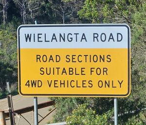
| 4wd_only=recommended | Roads that are best navigated by off road vehicles. Conventional road vehicles may be able to use these roads, but may challenge inexperienced drivers or risk vehicle damage. | Mount Korong Firebreak Track |
 Road sign at Wielangta Road | |
| 4wd_only=yes | Roads that can only be navigated by off road vehicles. Conventional road vehicles would not be able to use these roads at all. | Kidson Track |
image needed
| |
| 4wd_only=extreme | Roads so treacherous they can only be navigated by experienced off road drivers in specially equipped or modified vehicles. | Ruby Gap Park |
image needed
|
Dry Weather Only / Seasonal Roads
Roads that are only suitable in certain kinds of weather can be mapped using conditional restrictions, or seasonal=*.
An example of these are roads, tracks & walking trails in the Victorian High Country, that are usually closed from June - October. In addition to normal highway=* tagging, they could also be tagged as access:conditional=no @ (Jun-Oct) + seasonal=yes
Road Rules
School Zones
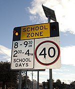
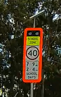
School zones can be mapped using the maxspeed:conditional=* tag in conjunction with the "SH" opening hours syntax. Each state and territory has its own speed zone laws and the table below can be a helpful guide to tagging these restrictions accurately. Most states introduce a 40km/h or 60km/h speed limit during times where children are likely to be present.
| S/T | Description | Tag Suggestion | Example | Photo | Road Sign |
|---|---|---|---|---|---|
| ACT | 40km/h between 8am and 4pm Monday-Friday. The school zone signs are folded up and hidden during school holidays. | maxspeed:conditional=40 @ (Mo-Fr 08:00-16:00; SH off) | Davenport Street, Dickson |

|
|
| NSW | Standard Times are 8am to 9:30am, and 2:30pm to 4pm. Individual zones can vary. | maxspeed:conditional=40 @ (Mo-Fr 08:00-09:30,14:30-16:00; PH off; SH off) | Yass Street, Queanbeyan |

|
 traffic_sign=AU:R4-230 traffic_sign=AU:R4-230
|
| NT | Standard Times are 7am to 5pm on School Days. Individual zones can vary | maxspeed:conditional=40 @ (Mo-Fr 07:00-17:00; PH off; SH off) | Belyuen Road, Rosebery |
image needed | |
| QLD | Standard times are 7am to 9am, and 2pm - 4pm on School Days. Individual zones can vary. | maxspeed:conditional=40 @ (Mo-Fr 07:00-09:00,14:00-16:00; PH off; SH off) | Yundah Street, Shorncliffe |

|
 traffic_sign=AU:R4-Q01 traffic_sign=AU:R4-Q01
|
| SA | School Zones operate at all times, "when children present". This includes pedestrians and cyclists. | maxspeed:conditional=25 @ ("children present") | Long Street, Whyalla |
||
| TAS | The times for each school vary, but are generally consistent with the times used in other states | Varies - see other states above. | George Street, Currie |
||
| VIC | Standard Times are 8am to 9:30am, and 2:30pm to 4pm. Individual zones can vary | maxspeed:conditional=40 @ (Mo-Fr 08:00-09:30,14:30-16:00; PH off; SH off) | Great Alpine Road, Bruthen |
 traffic_sign=AU:R4-V105 traffic_sign=AU:R4-V105
| |
| WA | There are three different standards for school zone times. Northern WA is 7:30am-9am, 2pm-3:30pm Carnarvon is 7:30am-9am, 2pm-4pm Rest of WA is 7:30am-9am and 2:30pm-4pm. |
maxspeed:conditional=40 @ (Mo-Fr 7:30-09:00,14:00-15:30; PH off; SH off) maxspeed:conditional=40 @ (Mo-Fr 7:30-09:00,14:00-16:00; PH off; SH off) maxspeed:conditional=40 @ (Mo-Fr 7:30-09:00,14:30-16:00; PH off; SH off) |
Kent Street, Kensington |
Speed Limits
It's good practice to include the maxspeed=* tag on each road, the source:maxspeed=* (indicating where the speed limit is sourced), and the maxspeed:type=* (indicating the nature of the speed limit) where possible.
| Value | Description | Aust. Usage |
|---|---|---|
| source:maxspeed=local_knowledge | If you know the speed limit from local knowledge. | |
| source:maxspeed=survey | If the speed limit was sourced from a survey. | |
| Value | Description | Aust. Usage |
| maxspeed:type=sign | For a signposted limit. | |
| maxspeed:type=AU:urban | For tagging an implicit speed limit in urban areas (60km/h in NT; 50km/h elsewhere). | |
| maxspeed:type=AU:rural | For tagging an implicit speed limit in rural areas (110km/h in NT, WA and some parts of QLD; 100km/h elsewhere). |
Traffic Enforcement
There are plenty of different forms of fixed traffic enforcement devices throughout Australia which should be mapped and tagged in OSM. The enforcement relation should be used to map the permanently installed device which makes the particular measurement, related to the way that enforcement applies to.
The enforcement=* key uses some language which is not the standard Australian English language. For example, where an Australian might refer to an enforcement device as a "red light camera", it should be tagged with enforcement=traffic_signals.
Yellow mobile phone detection trailers are movable and temporary, and therefore should not be mapped on OSM. However, many Variable Messaging Signs will have cameras which appear as black boxes attached to them, which are permanent mobile phone detection cameras and should be mapped. Mobile phone detection cameras detect at distances of approximately 20–30 m, and the relationship should extend as such.
As of 01 July 2024, mobile phone detection cameras in NSW also detect seatbelt offences. Where a single device enforces multiple rules, the values of the enforcement key should be placed in alphabetical order.
| Enforcement Device | Tags | Required roles | Comment |
|---|---|---|---|
| Speed camera | type=enforcement + enforcement=maxspeed + maxspeed=number in km/h | device |
|
| Average speed camera | type=enforcement + enforcement=average_speed + maxspeed=number in km/h* | device |
The from and to nodes are to be placed where the initial and final measurements are taken, respectively. |
| Red light camera | type=enforcement + enforcement=traffic_signals | device |
See enforcement for examples and more information. |
| Mobile phone (and seatbelt, in NSW) cameras | type=enforcement +
enforcement=mobile_phone or enforcement=mobile_phone;seatbelt |
device |
The from node should be approximately 20–30m from the device. |
| Access (e.g., T-way, bus-lane, etc.) | type=enforcement + enforcement=access +, e.g., psv:*=yes motor_vehicle:*=no | device |
View the access=* key for more information on how to appropriately tag access limitations. |
| Combined speed and red light camera | type=enforcement + enforcement=maxspeed;traffic_signals + maxspeed=number in km/h | device |
|
| * optional/not always applicable. † more than one is required. | |||
Heavy Vehicle Enforcement
There are multiple different types of cameras that monitor heavy goods vehicles and their compliance with regulations. These cameras are operated by the New South Wales and South Australian government in their respective states, and the federal National Heavy Vehicle Regulator elsewhere. These cameras can be mapped using highway:hgv=fatigue_management_camera and/or enforcement:hgv=fatigue_management_camera.
Local Traffic Only
"Local Traffic Only" signs are common in residential areas in Australia and are intended to discourage roads from being used by through traffic. As these signs are not legally enforceable, the tag-value combination motor_vehicle:advisory=destination is the preferred tagging.
U-turn at traffic signals
Generally, u-turn's are not permitted at traffic signals however in some cases, you are permitted to if there is a "U-turn permitted" sign. If a sign is typically present at the traffic signals but has been removed, it is illegal to conduct a u-turn. Due to this, it is recommended that a relation uses the restriction:conditional=* tag instead of having no turn restriction at the intersection.
restriction:conditional=no_u_turn @ ("If the u-turn permitted sign has been removed")
note=U-turn permitted by sign
Road Access and Roadside Features
Private Roads
Private roads can be mapped using the appropriate access=* restriction. This includes access roads on public land (sometimes sign as "Management Vehicles Only", or similar).
Roadside Rest Areas
There are many different tags that mappers can use to accurately describe a roadside rest area. Most common is the global tag: highway=rest_area.
Some rest areas are located within a town park and should be tagged as leisure=park. Larger rest areas may have separate amenity=parking areas mapped, and dedicated heavy vehicle parking can be mapped using access=no with hgv=designated (and capacity:hgv=* if known).
When camping is permitted, the rest area can also be tagged as a tourism=camp_site, with the maximum camping time indicated with maxstay=*.
Driver Revivers
Driver Reviver stations are often located at rest areas, but good practice is to leave these temporary services unmapped.
"Milestones"
Milestones are the plates on a post at the side of a highway that indicate e.g. "MH 10" , which in this case indicates that Mandurah is 10km away. They should be mapped by adding a node at that location beside the road, tagged as:
highway=milestone + destination=* + distance=*
Road Mapping Techniques
Roundabouts
As a general rule, all roundabouts in Australia are drawn out as a way with the junction=roundabout tag, in a clockwise direction. Single node highway=mini_roundabouts aren't used at all.
Names
Always use official sources, such as those from the state or territory government listed on the Australian Data Sources page.
Dual Road Naming
A common feature of many roads in Australia is dual naming. This often occurs a major highway passes through a small town, when a local name is used in preference to the "highway name". The local name is normally the most suitable choice for the name=* tag, and other names can be included in the alt_name=* tag. As always, using a note=* can help future mappers understand the issue.
Unnamed Roads
Where a road does not have an official name, use the noname=yes tag.
Gazetted 'Paper' Roads
There are many rural roads that are not trafficable despite having been gazetted. Some may be overgrown, sold to adjacent property owners, or may have never even been built. When mapping these roads, always ensure to use the most up-to-date imagery (or, even better, survey), and take care not to confuse features such as fences, dry creek beds, etc for a road.
These roads can be mapped with the appropriate tags indicating their condition, access, and trafficability.
- For private roads, use the appropriate access=* tag.
- Use the current state of the road to determine the appropriate highway=* tag
- For former and proposed roads, use the appropriate lifecycle prefix.
Routes
Each state and territory has its own system for allocating route numbers. Many states have moved to the newer, "alphanumeric" numbering system for route allocation. Other states are still in the process of transitioning to the new system, or haven't started transitioning at all, and continue to use the "old style" numeric routes. Both route types of route numbers should be documented with the ref=* and network=* tags
Network tags
The network=* tag should be used to identify the state or territory in which a road is located, while the ref=* tag should contain the route number. For alphanumeric route numbers, the ref=* should include the route letter prefix.
| Alpha-numeric routes | ||||||
|---|---|---|---|---|---|---|
| M M1 |
A A1 |
B B10 |
C C123 |
D D1 |
R R1 |
ALT A |
| ref=route number network=AU:S/T |
ref=route number network=AU:S/T:ALT | |||||
| Numeric routes | ||||||
|---|---|---|---|---|---|---|
| National Route |
Alt National Route |
National Highway |
State Route |
Alt State Route |
Metroad |
Tourist Route |
| ref=route number network=AU:S/T:NR |
ref=route number network=AU:S/T:ALT_NR |
ref=route number network=AU:S/T:NH |
ref=route number network=AU:S/T:S |
ref=route number network=AU:S/T:ALT_S |
ref=route number network=AU:S/T:MR |
ref=route number network=AU:S/T:T |
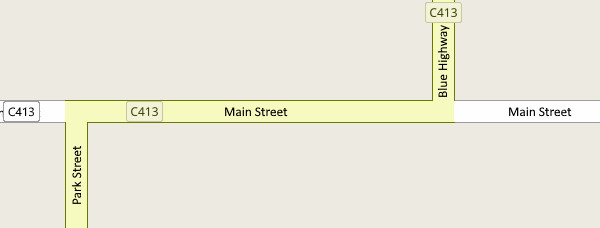
Example of a numeric route:
| ||||||
| Special Tourist Routes | |||
|---|---|---|---|
| State_Strategic_Touring_Routes_in_Queensland (QLD) ABC |
Tourist Drives (Logos) (QLD) (various shields - see TMR) | ||
| ref=route ref network=AU:QLD:SSTR |
network=AU:QLD:TD:Brisbane_Valley | network=AU:QLD:TD:Bunya | network=AU:QLD:TD:Cobb_Co |
| Great Barrier Reef Tourist Drive | Cane Cutter Way Tourist Drive | ||
| network=AU:QLD:TD:MB ref=Northern/Southern |
network=AU:QLD:TD:GBR | network=AU:QLD:TD:Cane_Cutter | |
| Cassowary Tourist Drive | Dinosaur Way Tourist Drive | ||
| network=AU:QLD:TD:Cassowary | network=AU:QLD:TD:Dinosaur | network=AU:QLD:TD:Muttaburrasaurus | |
network=AU:QLD:TD:Cobb_Co
Example of a special tourist route: Cobb & Co Tourist Drive
| |||
Route and Highway Relations
Each route number should have its own route=road relation consisting of each constituent road.
Many named routes and highways will be known by different names as they pass through towns and cities; most famously the Princes Highway. These major routes should also be given their own, separate, relation.
Interstate Routes
When a route crosses a state boundary, the route relation should be split into multiple single state routes and added to a "national" super-relation.
Old Route Scheme
|
This section of the guidelines is deprecated, and is kept for historical reference. Join the discussion |
The previous tagging guidelines documented a different scheme for mapping routes and route numbers.
| M | A | B | C | D | R |
|---|---|---|---|---|---|
Mnn |
Ann |
Bnn |
Cnn |
Dnn |
Rnn |
| ref=Mnn | ref=Ann | ref=Bnn | ref=Cnn | ref=Dnn | ref=Rnn |
| National Route | Alt Nat. Route | National Highway | State Route | Tourist Route |
|---|---|---|---|---|
nn |
nn |
nn |
nn |
nn |
network=NR |
network=alt_NR |
network=NH |
network=S |
network=T
|
where nn is a one- or two-digit number.
| Network | Ref | SVG Image | Description/Notes |
|---|---|---|---|
| T | brisbane_valley | Brisbane Valley Heritage Trail (TL-Q01_2). Non-commercial use only. | |
| T | bunya | Great Bunya Tourist Drive (TL-Q01_4). Non-commercial use only. | |
| T | cobbco | Cobb and Co Tourist Drive (TL-Q01_1). Non-commercial use only. | |
| T | dugong | Moreton Bay Tourist Drive (TL-Q01_9). Non-commercial use only. | |
| T | muttaburrasaurus | Muttaburrasaurus Tourist Drive (TL-Q01_3). Non-commercial use only. | |
| T | ?
|
Dinosaur Way Tourist Drive (TL-Q01_5). | |
| T | ?
|
Cassowary Tourist Drive (TL-Q01_6). | |
| T | ?
|
Cane Cutter Way Tourist Drive (TL-Q01_7). | |
| T | ?
|
Great Barrier Reef Tourist Drive (TL-Q01_8). |


