Balkan Province
| V・T・E Balkan welaýaty |
| latitude: 39.462, longitude: 54.756 |
| Browse map of Balkan Province 39°27′43.20″ N, 54°45′21.60″ E |
| Edit map |
|
External links:
|
| Use this template for your locality |
Balkan Province is a province in Turkmenistan, Central Asia at latitude 39°27′43.20″ North, longitude 54°45′21.60″ East.
Notes on Balkan Province
Balkan Province's major industries include oil and natural gas production and processing, transportation and logistics, and fisheries. The capital city is Balkanabat. A major oil refinery is located in Turkmenbashy, a petrochemical plant near Kiyanly (Turkmen: Gyýanly), and a urea (carbamide) plant in Garabogaz. The Turkmenbashy International Seaport can handle up to 25 million metric tons of dry cargo per year, following a massive expansion. Bereket is a major rail junction, where the east-west mainline of the historic Kushka rail line built by the Russian Empire in the 1880s crosses the north-south line linking Kazakhstan and Iran that was put in service in December 2014.
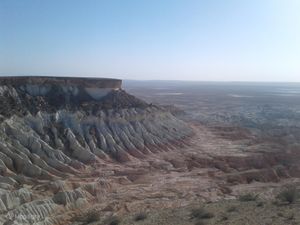
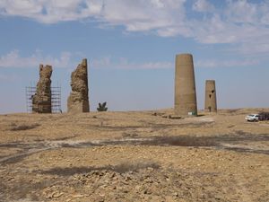
The historic Dehistan ruins and scenic Yangy Kala Canyon are among Balkan Province's tourist destinations.
Portions of the Soviet science fiction motion picture "Kin-Dza-Dza" were filmed on the sand dunes of the Cheleken Peninsula in Balkan Province.
Administrative Subdivisions
See also Districts in Turkmenistan and Turkmenistan Geoname Changes
Balkan Province (Balkan welaýaty) is subdivided into 6 districts (etrap, plural etraplar):[1]
- Bereket (previously Gazanjik)
- Esenguly
- Etrek (previously Gyzylektrek)
- Magtymguly (previously Garry Gala)
- Gyzylarbat (from 1999 to 2022 Serdar, and previously Gyzylarvat)
- Türkmenbaşy (previously Krasnovodsk)
As of 9 November 2022, the province includes 10 cities (города or şäherler), 14 towns (посёлки or şäherçeler), 30 rural or village councils (сельские советы or geňeşlikler), and 114 villages (села, сельские населенные пункты or obalar).[2][3][4] Of the cities, 2 bear the status of cities "equivalent to a district":
- Balkanabat
- Türkmenbaşy
Infrastructure
Major industrial sites in Balkan Province (Balkan welaýaty) include:
- oil fields featuring many oil wells on the Cheleken Peninsula;
- a petrochemical plant at Kiýanly (Gyýanly) for producing polyethylene and polypropylene;
- a urea and ammonia plant just south of Garabogaz.
- the Bereket Locomotive Depot, a major locomotive maintenance facility serving the Kazakhstan-Turkmenistan-Iran rail line;
- the Turkmenbashy Oil Refinery;
- the Turkmenbashy International Airport, and
- the Turkmenbashy International Seaport.
Construction Projects
- In December 2020 the Turkmen Ministry of Construction announced a tender for building a new airport in the town of Jebel.[5]
Вы можете помочь! You can help!
- Turkmenistan in Mapillary ground-level imagery
- Turkmenistan in OpenStreetCam ground-level imagery
- Public GPS traces tagged "Turkmenistan"
- Admin Level tag usage in Turkmenistan
Here are a few things you can do to help improve the Turkmenistan map in Balkan Province: Вот некоторые вещи, которые вы можете сделать, чтобы помочь улучшить карту в Балканском велаяте Туркменистана:
- Research and draw the boundaries of the Awaza borough of Turkmenbashy. Расследовать и нарисовать черты (границы) районa Awaza в городе Туркменбаши.
- Translate this page into Turkmen and Russian. Перевести эту статью на туркменский и русский языки.
Reference Materials
- ПОСТАНОВЛЕНИЕ МЕДЖЛИСА ТУРКМЕНИСТАНА от 29 июля 2013 года №420-IV Об образовании новых этрапов в городе Туркменбаши Балканского велаята 29 July 2013
- Балканский велаят: административно-территориальные изменения 27 May 2016
- ПОСТАНОВЛЕНИЕ МЕДЖЛИСА ТУРКМЕНИСТАНА Об административно-территориальных вопросах Балканского велаята 27 May 2016
- Рассмотрены вопросы совершенствования административно-территориального устройства велаятов 22 October 2022
- Постановление Меджлиса Милли Генгеша Туркменистана 10 November 2022
- Türkmenistanyň Milli Geňeşiniň Mejlisiniň Karary 10 November2022
References
- ↑ “Административно-территориальное деление Туркменистана по регионам по состоянию на 1 января 2017 года”.
- ↑ “Рассмотрены вопросы совершенствования административно-территориального устройства велаятов” (in ru). Государственное информационное агентство Туркменистана (TDH) - Туркменистан сегодня. 22 October 2022.
- ↑ “Постановление Меджлиса Милли Генгеша Туркменистана” (in ru). Государственное информационное агентство Туркменистана (TDH) - Туркменистан сегодня. 10 November 2022.
- ↑ “Türkmenistanyň Milli Geňeşiniň Mejlisiniň Karary” (in tk). «Turkmenistan: Golden age». 10 November2022.
- ↑ “Международный тендер на проектирование и строительство нового аэропорта в посёлке городского типа Джебел города Балканабат” (in Russian). Нейтральный Туркменистан. 14 December 2020.
See Also
- Balkan Province on Academy of Sciences website (in the Russian language)
- Balkanabat
- Law on Administrative-Territorial Structure of Turkmenistan, in Russian (О порядке решения вопросов административно-территориального устройства Туркменистана)
- List of Cities in Turkmenistan (Turkmenwiki, in Russian) (includes former names for reference)
- List of Cities in Turkmenistan (Wikipedia, in Russian) (includes former names for reference)
- List of Districts of Turkmenistan (Wikipedia in English) (CAUTION: Not up to date as of 20 May 2018, especially with respect to the city of Ashgabat, use with extreme caution! For Ashgabat, refer to the map of boroughs, link to which is found in the Ashgabat article.)
- List of Renamed Cities in Turkmenistan (Wikipedia, in English)
- List of Towns in Turkmenistan (Wikipedia, in Russian) {CAUTION: Not fully up to date as of 19 May 2018; use with caution!)
- Toponym Dictionary of Turkmenistan, Ashgabat: Ylym, 1970 (in the Turkmen language and Cyrillic script)
- Turkmenistan
- Turkmenbashy
| ||||||||||||||


