Basildon Mapping Party 2009
This is a mapping event in Basildon on the Weekend of 26-27th September 2009
|
The map of Basildon so far |
Mapping Party
Mapping parties are events where anyone can come and participate in the OpenStreetMap project. OpenStreetMap is a free, open source map that can be contributed, edited and used by anyone anywhere. Mapping parties are social events where experienced and new mappers can meet to share and learn more about the project. The events are generally held in a public place, and allow time for discussion, mapping and editing. The event is open to all.
It's fun. It's free. You can help.
More about Mapping parties
Details
- When: Weekend of 26-27th September.
- Where: The Quays (Map)
- Contact
- --DrMark 21:27, 23 August 2009 (UTC)
- Email: mark.666@blueyonder.co.uk
- Phone: 07771 898688
- Event schedule:
- Saturday
- 10am meet-up
- Try to fill in to the East, as this side has least done.
- Pub mid-day & evening
- Sunday
- Meet 10am
- The West end of the town, and any filling in not done yesterday. This is of course a very ambitious description, and will only happen if we get 20+ mappers!
- Saturday
- If you own a GPS or laptop computer, please bring it along. If not, we will have GPS units to loan.
- Weather: This event is rain or shine.
Who's coming
- DrMark
- EdLoach (hope to commute from Clacton both days)
- Smsm1 Will be travelling to Pitsea on the Saturday, can't do Sunday due to unreasonable connections with the rail works (unless someone wants to give me a lift).
- Where from? I'll be driving out from Grays, any reasonable pickup considered ;) Mark
- Crystal Palace/Elmers End, so can train/cycle the first bit. Seems that I'd need to take the train to Dartford, then get the bike across, and could then meet at the north side of the Dartford crossing. However I'm thinking I should just spend the day entering my data from the Saturday. Smsm1 17:12, 26 August 2009 (UTC)
- Where from? I'll be driving out from Grays, any reasonable pickup considered ;) Mark
Venue
The Quays (Map), A pub in Bas Vegas, aka Basildon's Festival Leisure Centre
Mapping objectives
This is a large new town; residential areas are drawn out but seem strangely devoid of actual streets. Yahoo have not been to Basildon. Google haven't done too well either, with a rather splendid easter egg to the west.
Mapping Party Suggestions
This will be a GPS based event for a change - none too many of them these days, come & recapture the thrill of virgin territory!
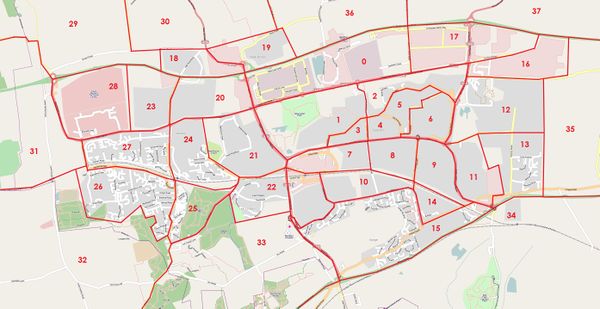
Party Cake
Click on the image for the full resolution version.
Imagine the slice between 22 and 10 with no number is labelled 38 (oops!).
Also imagine that I remembered to draw a line along the secondary road between slices 4 and 5.
Progress
Saturday
- 2 - EdLoach - roads surveyed
- 10 - Smsm1 som roads surveyed
- 11 - DrMark - roads & some POIs & some addresses
- 12 - EdLoach - roads surveyed
- 13 - DrMark - roads & some POIs & some addresses
- 14 - Smsm1 roads surveyed
- 15 - Smsm1 roads surveyed
- 16 - EdLoach - roads surveyed
- 17 - EdLoach - roads surveyed to the east of the main road through the slice
- 22 - DrMark - roads & some POIs & some addresses
- 38 - Smsm1 roads surveyed
http://www.trackmyjourney.co.uk/track/tGY4NMPQpbykR is the low res track of the route Smsm1 took.
Sunday
- 0 - EdLoach - roads surveyed in industrial sections (not Festival Park area)
- 0- DrMark - roads & some POIs in Festival park
- 1 - EdLoach - roads surveyed
- 3 - EdLoach - roads surveyed
- 4 - EdLoach - roads surveyed
- 5 - EdLoach - roads surveyed
- 6 - EdLoach - roads surveyed
- 7 - EdLoach - roads surveyed in the residential part of the slice
- 8 - EdLoach - roads surveyed
- 19 - DrMark - roads & some POIs but photos erased - oops!
- 21 - DrMark - roads & some POIs
- 24 - DrMark - roads & some POIs
EdLoach has uploaded his traces as identifiable and included a Basildon tag for those that contain at least some of Basildon. [1] as has Mark.

