Bicester
Jump to navigation
Jump to search
| V・T・E |
| latitude: 51.904, longitude: -1.155 |
| Browse map of Bicester 51°54′14.40″ N, 1°09′18.00″ W |
| Edit map |

|
|
External links:
|
| Use this template for your locality |
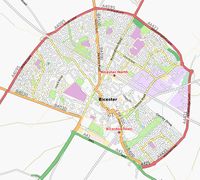
Bicester is a town in Oxfordshire at latitude 51°54′14.40″ North, longitude 1°09′18.00″ West.
Bicester is a small town in North Oxfordshire close to the M40.
Mapping progress
The area in the image contains roughly,
- 7,002 nodes with 228 tags
- 7,976 segments
- 2,282 ways with 3,921 tags.
TODO
Schools
- Cooper School (incorporating Glory Farm Primary and Bardwell) - mapped and mostly tracked. South east border which backs onto Lancaster close, Wellington Close is extrapolated. Individual school areas not done.
- South Park primary - mapped. The position of borders backing onto houses are guessed.
- Longfields primary - neither tracked or mapped.
- Brookside - neither tracked or mapped.
- St Marys - neither tracked or mapped.
- St Edburgs - mapped.
- Bicester Community College - neither mapped or tracked.
Misc
- Lots of unmapped footpaths in Leach road and Blenheim drive area map.
- Track the stream from where it leaves Bure Park and arrives at Hunt Close.
- Get tracks for railway lines south of Bicester North station and north of Bicester Town station.
- Football club. map.
- Cemetery, some paths missing. map.
- Garth Park. I think just the skate park and buildings left. map.