CartoType
| CartoType | |
|---|---|
| Author: | Graham Asher |
| License: | commercial |
| Platforms: | Windows, iOS, Android, macOS, Linux, Unix, and wasm |
| Version: | 8.10 (2024-05-28) |
| Language: | English |
| Website: | https://www.cartotype.com |
| Programming language: | C++ |
|
portable library | |
CartoType is a renderer and routing library. Platforms: Windows, .NET, iOS, Mac OS, Android, Linux, Web Assembly and other platforms supporting native C++ libraries. Map rendering and routing are performed on the device using off-line data. SDKs are available for C++ (Windows, Linux, Mac OS), Swift and Objective C (iOS), C# (.NET) and Java (Android). The CartoType Maps App ([1]) is a free multi-platform viewing and navigation program using CartoType.
There are two rendering systems: a hardware-accelerated renderer using OpenGL ES 2.0 and a software (CPU only) renderer. Both are available on all platforms.
CartoType is owned and developed by Graham Asher of CartoType Ltd.
It can import OSM data to its binary format as well as data from other sources including ESRI shapefiles and USGS SRTM digital elevation data. Evaluation SDKs and demonstration programs are available.
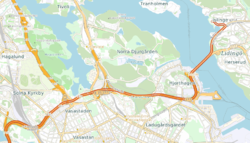
The image is a screen shot of a map of part of Stockholm, Sweden, created using CartoType from OpenStreetMap data. It also shows part a route calculated by CartoType's routing system.
