Category:Featured images/2013
Jump to navigation
Jump to search
These are featured images, which have been identified as the best examples of OpenStreetMap mapping, or as useful illustrations of the OpenStreetMap project.
If you know another image of similar quality, you can nominate it on Featured image proposals.
See also: Category:Featured images/2012 and Category:Featured images/2014
Subcategories
This category has only the following subcategory.
/
Pages in category "Featured images/2013"
The following 5 pages are in this category, out of 5 total.
Media in category "Featured images/2013"
The following 53 files are in this category, out of 53 total.
- HOT-Task-Manager-before-after-minova-kivu-rdc.png 750 × 526; 199 KB
- Year of edits 2012 video.png 550 × 400; 252 KB
- OSM-at-my-wedding.jpg 880 × 587; 270 KB
- Taginfo-tag-cloud.png 1,065 × 673; 545 KB
- Cartopartie-questembert.jpg 3,264 × 2,448; 1.74 MB
- Oooc screenshot.png 902 × 632; 662 KB
- T garmin.jpg 960 × 638; 72 KB
- Softcities map leggings.jpg 680 × 1,024; 319 KB
- Hackweekend-Karlsruhe-2013.jpeg 3,264 × 2,448; 1.63 MB
- Glasgow park access network.png 1,073 × 632; 160 KB
- Navit on OpenPandora.JPG 2,048 × 1,536; 731 KB
- HermeskeilOSMTraining.jpg 1,280 × 960; 223 KB
- Data tiles with 32MB of OpenStreetMap data.png 2,048 × 2,048; 29 KB
- UCAD team Dakar.JPG 693 × 520; 57 KB
- Magyarkert.png 654 × 472; 339 KB
- LeMondeMapBox.png 943 × 562; 367 KB
- STK Rostock compare.jpg 2,052 × 773; 276 KB
- Top 50 mappers in the US 2013.png 773 × 453; 502 KB
- Id-May 2013.png 925 × 689; 705 KB
- SOTM Argentina 2013 Group photo.jpg 1,024 × 683; 425 KB
- Canoe Mapping - La Boquilla Project.jpg 1,200 × 900; 246 KB
- Server-ramoth-and-bowser.jpg 1,200 × 900; 500 KB
- 731.jpg 3,264 × 1,952; 1.12 MB
- Sotm US 2013.jpg 3,994 × 1,156; 1.95 MB
- HOT Haiti Limonade Severin Workshop.jpg 600 × 450; 41 KB
- Nottingham tram construction diversion notice.jpg 750 × 628; 166 KB
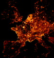
- OSM-node-density-map-HD-crop-2013.png 683 × 740; 273 KB
- Standard style scaled for low zoom.png 1,996 × 1,044; 1.4 MB
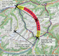
- Maxbe-stubaier-beschriftung en.png 820 × 780; 343 KB
- Fussgaengerzone access.JPG 836 × 1,452; 602 KB
- Mapeamento Colaborativo – Gestão Urbana SP 20130723 smaller.png 907 × 693; 853 KB
- Dal gps alla montagna.jpeg 1,280 × 854; 308 KB
- CIMG0227cake.jpg 900 × 600; 177 KB
- SOTM baltics 2013 group photo.jpg 1,596 × 1,107; 667 KB
- Dachwasserbrunnen.jpg 1,280 × 955; 275 KB
- 20130223 DSC1072 Looking at Buildings.jpg 2,121 × 1,414; 1.37 MB
- Sotm13 group photo CF.jpg 2,676 × 1,462; 1.89 MB
- BillboardAttribution.jpeg 2,020 × 639; 141 KB
- Battlegrid screenshot.png 753 × 511; 604 KB
- Humanitarian style.png 500 × 430; 129 KB
- Dressmap.it iPad cover at OSMit.jpeg 1,024 × 768; 81 KB
- SOTM scotland 2013 - Willie McMartin.jpg 1,600 × 1,067; 961 KB
- OpenMapSurfer HillshadeLayer.png 905 × 702; 1.14 MB
- Mapping party in Low Tatras 2013-10-13 traces.png 640 × 480; 583 KB
- OpenWeatherMap for Leaflet 2013-10-28 15-03-01.jpg 1,131 × 920; 164 KB
- Ebola Outbreak changesets vis.png 949 × 540; 261 KB
- Typhoon Haiyan changesets vis.png 785 × 526; 243 KB
- Everylinesf.jpg 1,024 × 768; 426 KB
- Three large poster maps of Tacloban, Guiuan and Ormoc.jpg 640 × 918; 198 KB
- FHRS Postcode OSM Highway.jpeg 2,362 × 1,771; 661 KB
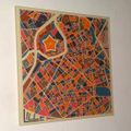
- Lille toile.jpg 548 × 549; 57 KB
- Guagua ESSC-OSMPH Training field survey.jpg 4,000 × 3,000; 2.65 MB
- OpenStreetMappy Xmas Biscuits.jpg 1,000 × 1,247; 483 KB


