Community Updates/2011-01-17
Community Update from 17 January 2011 to 23 January 2011 (week 2011-03)
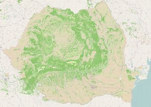
Image Of the Week 2011-03Romanian landuse – data from EEA comprises 100K polygons, imported to OSM December 2010 |
Project Of The Week : Banks
Banks banks banks. Not the banks of a river, but financial institutions. I'll just run out to the bank for a moment. But which bank is closest and most convenient? Do you need a bank with wheelchair access, or with drive through service? Or are you looking for a late night automated teller machine? We can put all of this information on the map and that is the Project of the Week. Map your local banks.
News Of The Week
- BBC News Coverage of Map Kibera
- talk-bd, a new OSM list for Bangladesh
- Maperitive can now read PBF files and has better right-to-left scripts support.
- New release of GpsMid 0.7.1
- Ongoing LINZ import in New Zealand
- FortiusOne developed a basic mapstyle for adding statistical informations on top [1]
- Skobbler released a OSM based puzzle game [2]
- A new version of Offmaps is released
- Upcoming Import of landcover in Ireland Republic_of_Ireland_Corine_2006_Import
Voting for default layer value for bridge and tunnel
This proposition introduce a default layer value for bridge=yes and tunnel=yes. Those will be fixed to layer=1 and layer=-1 respectively. All other elements will stay as is, i.e. with layer=0 by default.
If you want to give your advice, please vote on the given page.
Voting for Shop=Anime
The previously proposed feature about adding a "anime" value for the key shop, is now on the voting phase.
If you want to give your advice, please vote on the given page.
Voting for historic:civilization
this is a tag to describe roughly, which civilization (or ancient culture) has built a feature or is somehow else connected to it. The tag is mainly intended for historical features as a subtag to add further detail.
If you want to give your advice, please vote on the given page.
Capital or Administrative Center
Someone asked to the list how to tag administrative centers in OpenStreetmap, since administrative center of different level can vary with the level. After some discussions 2 solutions came out to the light:
the capital node tagged with place=city/town/...
and
admin_level=*  on the relation of the boundary
with the node of the place as admin_centre role.
or
admin_level=*
admin_centre=yes
on the place node
RFC: Better Healthcare
What kind of doctor is amenity=doctors? What about other public health related services such as home nursing? Maybe you want to do detailed mapping of support groups, counselling centres, health related amenities or services, without using tags of all the other in some kind always lacking proposals.
These are the kind of things that this proposition aims to solve. It use a full set of subtags to categorised all sorts of informations about healthcare.
If you have comments or idea, leave them on the given page
Thanks
As usual, this CU can't exists without your help, specialy : !i! ,ToeBee and Firefishy.

