Cranleigh Footpaths Party
There will be a mapping party this Saturday (13th) to complete the footpaths in the Cranleigh area of Surrey.
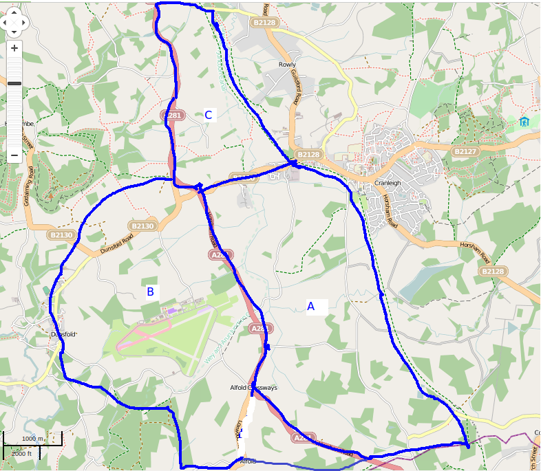
There will be three areas of focus:
- the area bounded by the B2130, A281, county boundary and old railway
- the area around Dunsfold, Alfold and Alfold Crossways
- the area bounded by the B2130, A281 and B2128 (small).
Meeting point is Cromwell Coffee House, High St, Cranleigh 9.30-9.45am. The plan will then be
- 1000 - 1300 Mapping
- 1300 - 1400 Optional lunch (due to the area being fairly scattered this might be tricky for some)
- 1400 - 1800 More mapping
- 1800 onwards pub, review day's progress, meal?
Joint OSM and FOSM event
This is a joint OSM and FOSM event. The map data will be collected as a public-domain .osm file at the end of the event, which can then be contributed to OSM or FOSM.
Weather
If the weather forecast is diabolical on the Friday evening (meaning: heavy continuous rain for most or all of the day; to give you an idea, today - Thursday - was passable this morning but not this afternoon) the event may be called off. Weather forecasts before Friday evening will be ignored as they frequently change up to the last moment. If this happens, cancellation will be advised by 2000 BST on Friday evening.
(Most mapping parties have had OK weather but the weather is very wet at the moment so just covering the eventuality...)
Who's coming
- nickw
- TimSC (emailed confirmation this week)
- PeterRounce
- 80n
- [enter your name]
