DE:Key:postal_code
| Beschreibung |
|---|
| Postleitzahlen |
| Gruppe: Adressen |
| Für diese Elemente |
| Status: in Benutzung |
| Werkzeuge für dieses Attribut |
|
Dieses Merkmal kann benutzt werden, um Postleitzahlen an Straßen, Postleitzahlenbezirken und Paketstationen zu kartieren. Die Verwendung des Tags ist -abgesehen von Paketstationen - in Deutschland nicht empfohlen, da die Postleitzahlen landesweit als Gebiete vorhanden sind.
- Für Postleitzahlen als Adressangabe wird stattdessen addr:postcode=* verwendet. Um die Nähe eines Objekts, z. B. einer Paketstation, zu einer Adresse anzugeben, kann object:postcode=* verwendet werden.
Schema für Straßen
Wenn eine Straße auf beiden Seiten die gleiche Postleitzahl hat, wird das mit postal_code=* kartiert. Hat die Straße auf ihrer Länge verschiedene Postleitzahlen, so wird sie an den Grenzen geteilt.
Schema für Postleitzahlgebiete
Es werden Relationen mit folgenden Tags benutzt:
Mitglieder der Relation
| Element | Role | Anzahl | Beschreibung |
|---|---|---|---|
| outer | 1 oder mehr | mehrere Wege |
Die Wege ![]() haben keine Tags oder sind die selben wie die politischen Grenzen.
haben keine Tags oder sind die selben wie die politischen Grenzen.
Postleitzahlensysteme
In Wikipedia werden die verschiedenen Systeme näher beschrieben. Siehe ![]() Postleitzahlen
( ) = optional
Postleitzahlen
( ) = optional
| Country | System | Example | Kosmos rendering rules |
|---|---|---|---|
| Australia | 0000 (4 digits) |
6797 | Kosmos postal code rendering rules/au |
| Austria | 0000 (4 digits) |
6797 | Kosmos postal code rendering rules/at |
| Germany | 00000 (5 digits) |
06797 | Kosmos postal code rendering rules/de |
| Romania | 000000 (6 digits) |
147202 | Kosmos postal code rendering rules/ro |
| Spain | 00000 (5 digits) |
99096 | Kosmos postal code rendering rules/sp |
| Switzerland | 0000 (4 digits) |
6797 | Kosmos postal code rendering rules/ch |
| The Netherlands | 0000 (4 digits) |
6797 | Kosmos postal code rendering rules/nl |
| UK | A(A)0(0) |
W1, SW20 | Kosmos postal code rendering rules/uk |
Sources of post code data
In an ideal world a databases of postal codes (and the locations they represent) would be managed by a government organisation, and they would share this freely without charges or restrictive licensing, because of the obvious economic benefits. Sadly this is not the case in most countries, and so we follow the same approach as with all of the other types of geo-data. We generally collect and build the data from scratch without copying from other sources. We also avoid using google maps to position things, and avoid copying from any other website/source which does so.
Postcodes from scratch?
Postcodes from scratch? Does this mean knocking on people's doors and asking what their postcode is?
Yes... That's the way we build our map. We survey and discover information on-the-ground. Postcodes are particularly tricky because you can't see them. They have poor verifiability, which in sense means they are not suitable for OpenStreetMap, but they have always been a type of geodata people were interested in releasing for free.
You can also discover postcodes on an individual basis without knocking on doors, by looking out for them on till receipts, restaurant menus. You can even look them up on the official website of the place. There is a slippery slope to watch out for with that. We don't want to systematically copy lots of postcodes from somebody's database.
Government sources
We can use government or other mapping agency sources where they have taken the sensible step of releasing the data openly, however "use" of such data might be thought about in terms of an import, i.e. converting the data and using it to set key:post_code tags in an automated way in the OpenStreetMap database. Imports require that we are very sure about the compatibility of the license and various other caveats. Import guidelines must be followed. A good alternative might be to devise ways of combining datasets while keeping them separate. For many end uses this can work well, although it will mean that some OpenStreetMap benefits such as Nominatim search matching will not come to pass.
Schema für Paketstationen
Folgende Tags identifizieren Paketstationen (amenity=locker) eines Anbieters üblicherweise eindeutig:
- ref=Zahl
- postal_code=Zahl
Style für JOSM
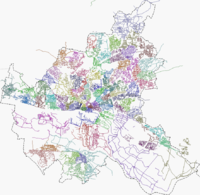
Für den Editor JOSM gibt es ein Style Coloured_Postcode, der die verschiedenen Postleitzahlen in unterschiedlichen Farben darstellt.
