Everett, WA Import
About
This page is intended to document plans for an upcoming import of data from the City of Everett, WA.
This is intended to be a craft-style import of addresses and buildings in Everett. This import is manually done and will be completed with an eye toward on-the-ground accuracy.
We plan to follow & update the plan found at import checklist, but our general high level plan is this:
- Identify data to import
- Translate, tag, and otherwise prepare the data
- Make sure the community are all on board with the plan.
- Do the work: Import/merge the data
The intent is to begin this effort in earnest in mid 2024.
Goals
The goal of this effort is to radically improve the quality of Everett address and building information in OpenStreetMap.
Schedule
- Planning: Mid 2024
- Import: Mid-Late 2024
- QA: During import
Import Data
Background
Address data will be derived from the City of Everett's GIS dataset. Permission was obtained explicitly via email and conversations with the legal team.
Data source site: https://data.everettwa.gov/Responsive-and-Responsible-Government/Building-Footprint/hhhk-5xe8
Data license/Permissions: See below
Data License
Permission to import under ODbL was obtained directly from the GIS and legal teams at the City of Everett via email interactions. After some time, the legal team confirmed that the data was able to be imported under ODbL.
Import Type
This is an OSM Seattle one-user, one-time import.
There are currently no plans to script or automate this import.
Data Preparation
Data was prepared in Alteryx, including abbreviation and directionality extensions. The workflow was the same used in the South King County Import with slight modifications for the data structure.
Useable fields include street number, street name, and zip code. City will be added.
Tagging Plans
No source tags will be added.
Data Transformation
The source files have been converted to OSM XML.
Data Transformation Results
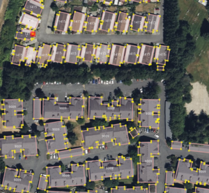
An example of the quality of the data is to the right:
Data Merge Workflow
References
- Local knowledge
- Bing/ESRI/DigitalGlobe aerial layer (depending on the age of the data)
- Existing OSM data
Workflow
- A section of building + address data will be obtained from the dataset roughly equaling the size of a census tract.
- Run validation on the existing OSM data layer that now contains new data, resolve all issues emanating from collisions between existing and new data.
- Existing buildings will not be replaced, unless the new building footprint is significantly higher quality using the replace function in JOSM.
- Any updates to the data will then be made manually, including updating out-of-date footprints or removing demolished buildings.
- Validation
- Upload data to OSM
Dedicated Import Account
A dedicated account will be used for the import, Omnific_Import
QA
Due to the non-automated nature of the import, QA will occur during the process. All data will be visually checked for out-of-date outlines, excess address nodes, poor quality outlines, etc.


