FR:Rendu de carte pour les randonnées
Si vous comprenez l’original en anglais, merci d’apporter votre aide pour compléter cette traduction française. Lisez les instructions concernant la traduction de ce wiki.
Personne ne semble travailler dessus actuellement, vous pouvez prendre cette tâche.
This wiki page is intended to gather feature ideas for a new OSM Slippy map layer, just like the Cycle Map but then especially for climbers, hikers, tramps, campers, walkers, horseriders and other countryside users.
Ideas and suggestions
- Displaying relief contour lines
- Rendering trail lengths automatically on the map
- Rendering of ways emphasizing paths and various track types, toning down unsuitable roads and paved streets
- Special attention to natural features
- Special attention to bridges and stairs
- Displaying walking routes (tagged with relations and or tags like highway=path) in different colors
- Icons for mountain, alpine huts, bothies, log cabins, wilderness huts,... see proposals: Proposed_features/Shelter and Proposed_features/Alpine_Hut
- Icons for nice views
- Icons for drinking water, toilets, wastebaskets, and so forth.
- Combine raw GPS of the same trail for better accuracy
- Link to sites and pages describing the details of a trail, information beyond the GPS path.
- Flags to identify starting/ending points of trails, including roundtrip routes
- A way to display parking lot locations
- Displaying safety ropes, ladders and rungs in assisted trails
- Displaying areas prone to avalanche hazard
Generic hints for renderers
Trails
- in case of a relation:route the code of the path should be rendered in text, this code is normally in ref=*. When name=* is present it should be displayed as well. In case of lack of space we should discuss which one has priority.
- in case of simple way, highway=path or highway=track or highway=footway, not included in a relation:route we should display the ref and/or name of the way.
As of 2013-09-10:
- In WayMarked Trails: the route ref=* is rendered (I'm not sure about the name=*). In absence of route, the way name is rendered and the ref is not.
- In hikebikemap.: informations in relation:route are ignored. The way name=* is rendered and if not available the ref=*.
- In the default mapnik style, Cyclemap, maps.refuges, dianacht, 4umaps: informations in relation:route are ignored. The way name=* is rendered while ref=* is not.
Difficulty
The combination of sac_scale=* and trail_visibility=* should be rendered with the line style and color. Examples can be found in sac_scale#Rendering or osmc:symbol=*. It makes sense to use these tags on single ways. Does it make sense to apply them to relation:route?
As of 2013-09-10:
- maps.refuges: follows the indications of sac_scale#Rendering.
- WayMarked Trails: follows the indications of osmc:symbol=*.
- In 4umaps: the sac_scale=* is rendered in text together with mtb:scale=*.
- the default mapnik style, Cyclemap, dianacht: no indication of difficulty is rendered.
Groups of features
At high scales the name of groups of features should be rendered, specifically:
- mountain ranges
- valleys
- lakes groups
As of 2013-09-10: dianacht: renders mountain ranges with the Proposed relation: Region mountain_area.
Map examples
OpenHikingMap
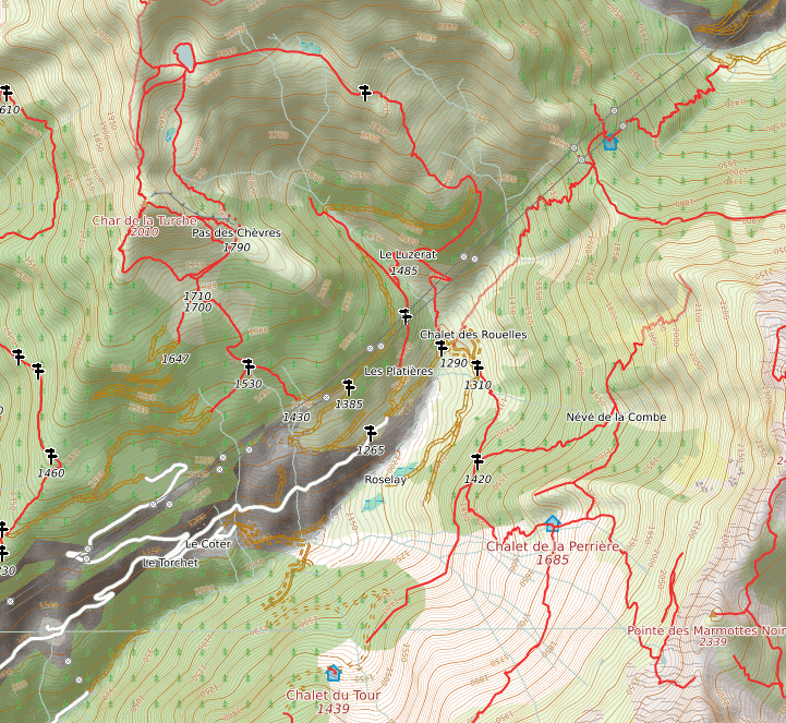
Here is my starting work on a Hiking Map I'm working on See details here
Hiking and Riding map
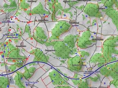
I have also started work on a topological hiking map (german). Or rather, as I am doing my mapping on horseback, I am working on a map that some day should be suitable for trail riding. But as the requirements for a hiking map are very similar, it should be able to serve that purpose as well. Main requirements are
- contour lines
- hill shading
- emphasis on displaying the trackgrades and paths
- landmarks of all kinds
- hiking routes.
My work on a hiking map originally started with a map for Garmin devices and OSM Composer. For the open layers map I extended Composer to generate matching mapnik styles. This means that a Garmin map will be available that exactly matches the online topo map minus the hill shading.
The basic setup is
- PostGreSQL/PostGIS database
- Contour lines created as shown in HikingBikingMaps
- Hills shading produced as shown in HikingBikingMaps, but with a modified gdal2tiles.py that darkens the tiles and names them in open layer nomenclature
- OSM data downloaded and processed with OSM composer
- evaluate and add hiking routes and some other information
- remove all unimportant data
- Two style sheets for Mapnik generated by OSM composer from the Garmin TYP definition, one for the foreground and one for the background
- Rendering done by mapnik as recommended by migurski
- render background (mostly land use)
- apply hill shading to background
- render foreground on top (contours, ways, nodes)
hiking.waymarkedtrails.org
See hiking.waymarkedtrails.orgwebsite]].
3D hiking maps

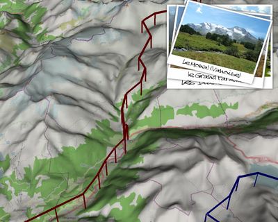
3D hiking maps (similar to Google Earth) can be produced with OpenSceneGraph (and SRTM data), even without internet connection. The screenshot on the right is an extract from a video trailer made to present (and prepare) a very long hike / mapping party along the Via Alpina (Summer 2012).
Related pages
- HikingBikingMaps
- WikiProject Germany/Wanderwege-Netz
- WikiProject Belgium/Walking_Routes
- WikiProject Belgium/Conventions/Walking Routes
- Proposed features/Guidepost
- Freemap
- OSM Composer Hiking maps for Garmin devices
- OpenAndroMaps offline hiking/biking maps for android devices
- Topo map Germany for Garmin devices
- Custom OpenStreetMap Rendering - OpenTrackMap Experience
- hikingbook.pl
- Hiking around the world

