File:Cubbon Park OSM Map.png
Jump to navigation
Jump to search


Size of this preview: 800 × 462 pixels. Other resolutions: 320 × 185 pixels | 640 × 369 pixels | 1,024 × 591 pixels | 1,280 × 739 pixels | 2,953 × 1,704 pixels.
Original file (2,953 × 1,704 pixels, file size: 997 KB, MIME type: image/png)
This is a Featured image, which means that it has been identified as one of the best examples of OpenStreetMap mapping, or that it provides a useful illustration of the OpenStreetMap project. If you know another image of similar quality, you can nominate it on Featured image proposals.
Front-page image for week 49 of 2012 (3–9 Dec.).
- Image descriptions
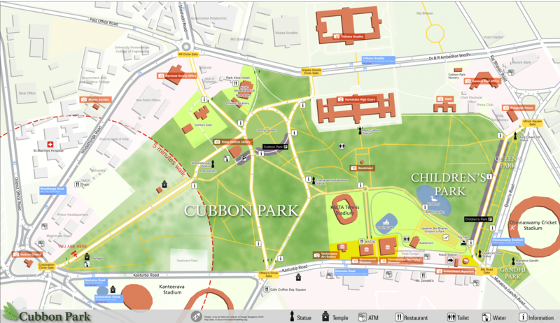
- Deutsch : Fußgängerkarte für den Cubbon-Park in Bangalore, erstellt als einen Teil eines Klassenprojekt von NID. Studenten entwickelten ein System von Navigation und Wegfinder für die Bescuher des Parkes. Daten wurden mithilfe WAlking Papers gesammelt, zum OSM hinzugefügt. Danach wurde es exportiert und mit Adobe Illustrator gerendert.
- English : Pedestrian Map for Cubbon park, Bangalore, created as part of a class project at NID. Students developed a system of navigation and wayfinding for visitors to the park. Data was collected using Walking Papers, added to OpenStreetMap, and then exported and processed in Adobe Illustrator for the final output.
- français : La carte piétone du parc Cubbon de Bangalore crée lors d'un projet scolaire du NID. Les étudiants ont développé un système de navigation et de guidage pour les visiteurs du parc. Les données ont été collectées graĉe aux Walking Papers, ajoutées à OpenStreetMap, puis exportées et traitées avec Adobe Illustrator pour l'épreuve définitive.
- italiano : Mappa pedonale di Cubbon Park, Bangalore, creata come progetto di classe al NID. Gli studenti hanno sviluppato un sistema di navigazione e di calcolo del percorso per i visitatori del parco. I dati sono stati raccolti con i Walking Papers, caricati su OpenStreetMap, e poi esportati e processati in Adobe Illustrator per il risultato finale.
- 中文(简体) : 印度班加罗尔的Cubbon公园行人地图,是NID课程作业的成果之一,学生替游客开发导航和寻路系统。这些资料来自Walking Papers的实地踏察,之后加到开放街图上,最后运用Adobe Illustrator处理汇出的资料变成最终成品。
- 中文(繁體) : 印度班加羅爾的Cubbon公園行人地圖,是NID課程作業的成果之一,學生替遊客開發導航和尋路系統。這些資料來自Walking Papers的實地踏察,之後加到開放街圖上,最後運用Adobe Illustrator處理匯出的資料變成最終成品。
File history
Click on a date/time to view the file as it appeared at that time.
| Date/Time | Thumbnail | Dimensions | User | Comment | |
|---|---|---|---|---|---|
| current | 08:26, 2 January 2011 |  | 2,953 × 1,704 (997 KB) | wikimediacommons>Planemad | update, higher res |
