File:Cyclenodenetwork-belgium.png

Original file (745 × 773 pixels, file size: 802 KB, MIME type: image/png)
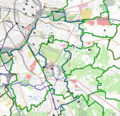
Custom rendering of a small part of the Belgian cycle network.
Front-page image on 24 May 2008
A map of a small part of the Belgian cycle network. This shows an alternative for the transparent rendering used on the cycle map, which makes the routes come out better on the map, especially where local and regional routes run along the same roads. Some extra tags are also interpreted to show alternate routes like shortcuts as dashed lines, or to show the local routes in different colours, which make them easier to follow than when they're all the same colour, because they overlap a lot.
A huge amount of work remains to be done to complete the cycle routes in Belgium. The cycle node network covers practically the entire northern part of the country and connects over 10.000 km of roads. The first network was invented in Belgian Limburg in 1995 and has now spread across the Benelux. The idea to number the junctions instead of the routes themselves came from the coal mining industry (which has now disappeared) where signs in the mine shafts showed the way towards junctions.
The network is so successfull that the first walking node networks are starting to appear as well.
File history
Click on a date/time to view the file as it appeared at that time.
| Date/Time | Thumbnail | Dimensions | User | Comment | |
|---|---|---|---|---|---|
| current | 12:31, 18 April 2008 |  | 745 × 773 (802 KB) | Eimai (talk | contribs) | |
| 11:50, 18 April 2008 |  | 906 × 875 (967 KB) | Eimai (talk | contribs) | Custom rendering of a small part of the Belgian cycle network. |
You cannot overwrite this file.
File usage
The following 2 pages use this file:
