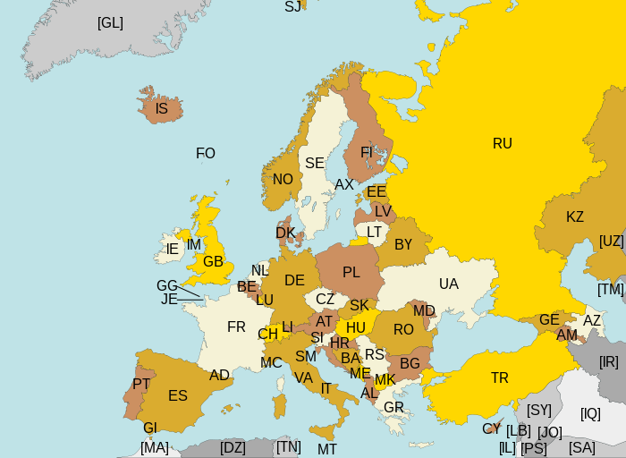
File:Europe ISO 3166-1.svg
From OpenStreetMap Wiki
Jump to navigation
Jump to search

Size of this PNG preview of this SVG file: 700 × 512 pixels. Other resolutions: 320 × 234 pixels | 640 × 468 pixels | 1,024 × 749 pixels | 1,280 × 936 pixels.
Original file (SVG file, nominally 700 × 512 pixels, file size: 384 KB)
This file and its description are from Wikimedia Commons.
Summary
| DescriptionEurope ISO 3166-1.svg |
Map of Europe, with ISO 3166-1 pt · en country and territory codes. SVG format. Map legend in Portuguese and English, with name of sovereign state given in parenthesis, where applicable:
Non-European countries and territories featured in map:
|
| Date | |
| Source | Own work |
| Author | Júlio Reis |
| Other versions | Without country codes: Europe countries.svg · Only continent boundaries: Europe continents.svg · Country names in Italian: Europa-it-politica-names-big.svg · Including Kosovo: Europe ISO 3166-1 (with Kosovo).svg |
| SVG development InfoField |
Licensing
This file is licensed under the Creative Commons Attribution-Share Alike 3.0 Unported license.
- You are free:
- to share – to copy, distribute and transmit the work
- to remix – to adapt the work
- Under the following conditions:
- attribution – You must give appropriate credit, provide a link to the license, and indicate if changes were made. You may do so in any reasonable manner, but not in any way that suggests the licensor endorses you or your use.
- share alike – If you remix, transform, or build upon the material, you must distribute your contributions under the same or compatible license as the original.
Captions
Add a one-line explanation of what this file represents
Items portrayed in this file
depicts
image/svg+xml
File history
Click on a date/time to view the file as it appeared at that time.
| Date/Time | Thumbnail | Dimensions | User | Comment | |
|---|---|---|---|---|---|
| current | 22:43, 10 August 2015 |  | 700 × 512 (384 KB) | wikimediacommons>SiBr4 | Increasing contrast by slightly changing the map colors; splitting Serbia and Montenegro; cropping some more; plain SVG |
File usage
The following 6 pages use this file:
Metadata
This file contains additional information, probably added from the digital camera or scanner used to create or digitize it.
If the file has been modified from its original state, some details may not fully reflect the modified file.
| Width | 700 |
|---|---|
| Height | 511.75 |
Retrieved from "https://wiki.openstreetmap.org/wiki/File:Europe_ISO_3166-1.svg"