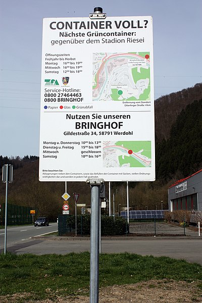
File:Hinweisschild Container voll mit OSM-Karte in Werdohl.jpg
Jump to navigation
Jump to search


Size of this preview: 400 × 600 pixels. Other resolutions: 160 × 240 pixels | 320 × 480 pixels | 512 × 768 pixels | 682 × 1,024 pixels | 1,365 × 2,048 pixels | 2,848 × 4,272 pixels.
Original file (2,848 × 4,272 pixels, file size: 4.69 MB, MIME type: image/jpeg)
This is a Featured image, which means that it has been identified as one of the best examples of OpenStreetMap mapping, or that it provides a useful illustration of the OpenStreetMap project. If you know another image of similar quality, you can nominate it on Featured image proposals.
Front-page image for week 21 of 2015 (18–24 May).
- Image descriptions
- Deutsch : Ein Hinweisschild mit Karten von OpenStreetMap zeigt die Positionen der Müllcontainer in Werdohl (Deutschland) an.
- English : A signpost designed with maps from OpenStreetMap, showing the location of recycling bins in Werdohl, Germany
- italiano : Un cartello stradale progettato com mappe di OpenStreetMap, che mostra la posizione dei contenitori per il riciclaggio in Werdohl, Germania.
- русский : Этот знак в немецком городе Вердоль показывает, где находятся ближайшие пункты приёма вторсырья. В основе карт — ОпенСтритМап.
- 中文(简体) : 使用开放街图地图的路牌,显示德国韦尔多尔一带的资源回收箱位置。
- 中文(繁體) : 使用開放街圖地圖的路牌,顯示德國韋爾多爾一帶的資源回收箱位置。
File history
Click on a date/time to view the file as it appeared at that time.
| Date/Time | Thumbnail | Dimensions | User | Comment | |
|---|---|---|---|---|---|
| current | 17:29, 12 May 2015 |  | 2,848 × 4,272 (4.69 MB) | wikimediacommons>Reneman | User created page with UploadWizard |
File usage
The following 6 pages use this file:
