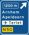
File:Nederlands verkeersbord K2.svg

From OpenStreetMap Wiki
Jump to navigation Jump to search

Original file(SVG file, nominally 420 × 500 pixels, file size: 30 KB)

View on Wikimedia Commons
This file and its description are from Wikimedia Commons.

Summary

Description
English: Netherlands road sign K2: Advance warning sign for an exit on a motorway showing the distance to the exit, the exit number, destinations after the exit (top destination is the name of the exit), direction to aerodrome/airport and the non-motorway road number (image 1 of 2)
Nederlands: Nederlands verkeersbord K2: Voorwegwijzer langs autosnelweg voor de afgaande richting, met afstandaanduiding, afritnummer, interlokale doelen (bovenste doel = afritnaam), verwijzing naar vliegveld/luchthaven en routenummer niet-autosnelweg (afbeelding 1 van 2)
Date
Source Verkeersborden en Verkeersregels in Nederland
Author SVG version by Bouwe Brouwer (talk)

Licensing

Public domain
This image shows a traffic sign which comes from the Regulation respecting traffic rules and road signs 1990 (RVV 1990) which is part of the legislation of the Netherlands and is therefore in the public domain (article 11 of the 1912 Copyright Act).

Deutsch | English | français | Nederlands | +/−

This file has been identified as being free of known restrictions under copyright law, including all related and neighboring rights.

Captions

Add a one-line explanation of what this file represents

Items portrayed in this file

depicts

8 February 2009

image/svg+xml

File history

Click on a date/time to view the file as it appeared at that time.

Date/TimeThumbnailDimensionsUserComment
current13:26, 8 February 2009Thumbnail for version as of 13:26, 8 February 2009420 × 500 (30 KB)wikimediacommons>Bouwe Brouwer{{Information |Description={{en|1=Advance warning sign of a motorway showing the distance to the next exit and destinations after the exit (the top destination is the name of the exit), direction to aerodrome/airport and the road number (nonmotorway)}} {{