File:OSM-node-density-map-HD-crop-2013.png
Jump to navigation
Jump to search


Size of this preview: 553 × 599 pixels. Other resolutions: 221 × 240 pixels | 443 × 480 pixels | 683 × 740 pixels.
Original file (683 × 740 pixels, file size: 273 KB, MIME type: image/png)
Summary
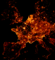
OpenStreetMap node density as of 2013-05-22 based on Frederik's densely mapped locations analysis. Each pixel represents one tile at zoom-level 13. Read more - howto.
This is a cropped version of File:OSM-node-density-map-HD-2013.png.
This is a Featured image, which means that it has been identified as one of the best examples of OpenStreetMap mapping, or that it provides a useful illustration of the OpenStreetMap project. If you know another image of similar quality, you can nominate it on Featured image proposals.
Front-page image for week 27 of 2013 (1–7 Jul.).
- Image descriptions
- Deutsch : Keine Vulkanausbrüche, keine Waldbrände, sondern brennende Leidenschaft der OpenStreetMap-Freiwilligen – repräsentiert durch eine Karte, die die farbkodierte Knoten-Dichte der OpenStreetMap-Daten abbildet. Alternative Ansichten: ganze Welt als Slippy-Map, ganze Welt als ein Bild (67 Mpx, 1 MiB); herunterskalierte ganze Welt, mehr Informationen über die Erstellung.
- English : No volcanic eruptions, no wildfires, but burning passion of OpenStreetMap volunteers – represented by a map showing the colourised node density of OpenStreetMap data. Alternative views: full world as slippy map, full world as single image (67 Mpx, 1 MiB); full world scaled down, more info how this was created.
- español : No son erupciones volcánicas, incendios forestales, pero si una pasión ardiente de los voluntarios de OpenStreetMap – en el mapa se representa mediante un color la densidad del nodo de datos de OpenStreetMap. Vistas alternativas: el mundo completo en un slippy map, el mundo completo en una sola imagen (67 Mpx, 1 MiB); el mundo completo a baja resolución, más información de cómo fue hecho.
- français : Il n'y a pas d’irruptions volcaniques, pas non plus de feu de forêt, mais seulement la passion ardente des volontaires d'OpenStreetMap – Représentés par une carte affichant les nœuds de densité colorés des données d'OpenStreetMap. Vues alternatives : Monde entier en carte glissante, Monde entier en une seule image (67 Mpx, 1 Mio); Le monde entier réduit, Plus d'information sur le processus de création.
- italiano : Nessuna eruzione vulcanica, nessun incendio, ma la passione che infiamma i volontari di OpenStreetMap, rappresentata su una mappa che mostra a colori la densità dei nodi nei dati di OpenStreetMap. Rappresentazioni alternative: tutto il mondo come slippy map, tutto il mondo come immagine singola (67 Mpx, 1 MiB); tutto il mondo ridotto, ulteriori informazioni sulla creazione (in inglese).
- Nederlands : Dit zijn geen vulkaanuitbarstingen of natuurbranden, maar brandend enthousiasme van OpenStreetMap-vrijwilligers – weergegeven op een kaart die de dichtheid van knopen in OpenStreetMap aangeeft. Alternatieve weergaven: de hele wereld als inzoombare kaart, de hele wereld als één afbeelding (67 megapixels, 1 MiB); de hele wereld op kleinere schaal, meer informatie over hoe dit gemaakt is.
- русский : Цвет на этой карте показывает плотность точек в базе данных ОСМ. См. покрытие всего мира в виде интерактивной карты и одной картинкой.
- 中文(简体) : 不是火山爆发,也不是野火肆虐,而是热情的开放街图志愿者的表现;- 经由地图上着色的节点代表开放街图资料密度。另一个地图: 全球互动地图,-HD-2013.png 全球一张图 (67 Mpx, 1 MiB); 全球尺度缩小,更多关于怎么制作的资讯。
- 中文(繁體) : 不是火山爆發,也不是野火肆虐,而是熱情的開放街圖志願者的表現;- 經由地圖上著色的節點代表開放街圖資料密度。另一個地圖: 全球互動地圖,全球一張圖 (67 Mpx, 1 MiB); 全球尺度縮小,更多關於怎麼製作的資訊。
Licensing
based on © OpenStreetMap data (ODbL).
This work is licensed under the Creative Commons Attribution-ShareAlike 2.0 License.
Attribution not specified as a parameter! THIS LICENSE ALWAYS REQUIRES ATTRIBUTION! Use {{CC-BY-SA-2.0|Attribution, typically name of author}} See Template:CC-BY-SA-2.0 for full description how this template should be used.
Note, there is
There is also
Attribution not specified as a parameter! THIS LICENSE ALWAYS REQUIRES ATTRIBUTION! Use {{CC-BY-SA-2.0|Attribution, typically name of author}} See Template:CC-BY-SA-2.0 for full description how this template should be used.
Note, there is
{{CC-BY-SA-2.0 OpenStreetMap}} for files based on old OSM map data, before the license change made on 2012-09-12.There is also
{{OSM Carto screenshot||old_license}} for files based on old OSM map data, before the license change made on 2012-09-12, created using OSM Carto map style.
See also
File history
Click on a date/time to view the file as it appeared at that time.
| Date/Time | Thumbnail | Dimensions | User | Comment | |
|---|---|---|---|---|---|
| current | 19:29, 27 June 2013 |  | 683 × 740 (273 KB) | Tyr (talk | contribs) | |
| 17:21, 27 June 2013 |  | 683 × 740 (400 KB) | Tyr (talk | contribs) | tbd |
You cannot overwrite this file.
File usage
The following 9 pages use this file:


