GPSMapEdit
| GPSMapEdit | |
|---|---|
| Author: | Konstantin Galichsky |
| License: | proprietary shareware |
| Platform: | Windows |
| Version: | 2.1 update 78.18 (2021-03-19) |
| Languages: | Amharic, German, English, Spanish, Persian, Finnish, French, Italian, Japanese, Polish, Portuguese, Russian, Swedish, Turkish, Tatar, Ukrainian, Simplified Chinese, and Traditional Chinese |
| Website: | http://www.geopainting.com/ |
| Programming language: | C++ |
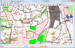
GPSMapEdit is an editor for maps in the Polish format, popular in Russia.
License
It's a shareware program. To display maps in the Garmin file format .img you don't need to buy the program. Ported on various versions of Windows (using the native Win32 API) or under Wine, its source code (of version 1.0), is available for personal use, it cannot be used to publish derived versions without authorization from the author.
Features
This software is designed for visual authoring of maps, and allows inserting custom POIs and speedcams for: Garmin POI Loader, iGO, TomTom OV2, Navitel Navigator, CityGuide.
It supports various cartographic formats compatible with GPS/WGS84 coordinates: Polish format, Garmin MapSource/BaseCamp, Lowrance MapCreate, CityGuide (navigation software for Windows Mobile, Android, Symbian, iPhone), Navikey 7 Ways, Navitel Navigator 3.x, ALAN Map 500/600, Holux MapShow, Google Earth.
The program may also load and convert GPS-tracks, waypoints and routes in various formats: GPX, KML/KMZ, Garmin, iGO 8, iGO Primo, Lowrance, Magellan, Nokia, OziExplorer, ALAN, Holux.
Other supported file formats are: bitmap images (JPEG 2000, JPG, BMP, GIF, PNG, TIFF, EXIF), popular data files (CSV, XLS, DBF, MDB), and others (ECW, MrSID, KML/Google Maps, ESRI shapefile, MapInfo MIF/MID).
See also
- GpsMapEdit Official site
- GPSMapEdit27 eng.zip - more download.

