IT:OpenPisteMap
|
OpenPisteMap (Discontinued) | |
|---|---|

| |
| Slippy map: | openpistemap |
| Style website: | subversion |
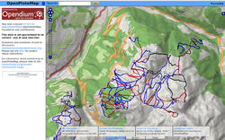
OpenPisteMap (http://openpistemap.org) mostra una mappa delle piste da sci e snowboard, basata sui dati di WikiProject Piste Maps. Questa pagina ne documenta la situazione attuale ed i progetti per il futuro.
Indice:
   1 Stato
   2 Source Code
   3 Robots and Abusive Clients
   4 To Do List
       4.1 Sentieri d'interesse per gli utenti delle piste
   5 Legenda dei simboli per gli impianti di risalita
Status
"OpenPisteMap dopo la migrazione sul nuovo serever presenta alcuni problemi.
Vi preghiamo di pazientare nell'attesa che siano risolti."
Il sito è funzionante ma i dati relativi ai tracciati delle piste non sono aggiornati da molto tempo, verosimilmente dall'inizio del 2012. In alternativa le piste da sci possono esser visionate attraverso openstreetmap.fr
Source Code
Available with SubVersion: http://subversion.nexusuk.org/projects/openpistemap/ Robots and Abusive Clients
There are a few brain-dead robots around that make such large numbers of tile download requests that they could easily be considered a denial of service attack. So, if you are writing or operating a robot, some simple rules:
   Put in some sensible limits on how big an area can be downloaded. Obviously the higher the zoom level, the smaller the maximum area size should be.
   Present a sensible user agent string in your requests. Don't pretend to be a web browser (e.g. Firefox) - yes, it really is easy to tell when it is a robot rather than a browser requesting the data. Similarly, don't just leave it set to a library's default (e.g. "Java").
   Putting an email address in the useragent string to allow you to be contacted in the event of any problems is sensible.
   If you start getting "403 Forbidden" responses, *stop*. Don't just keep hammering away at the server - it probably means that you've been banned for abusive behaviour and continuing to hammer away at the server will just extend your ban.
   If you're getting lots of "404 Not Found" responses then you are requesting tiles that haven't previously been rendered and the server is too overloaded to render them in real-time. Consider slowing down the request rate.
In order to protect the majority of users from the actions of a minority running abusive software, automatic banning is performed. Failure to follow the above points will likely result in a ban. Repeated abuse may lead to a permanent ban.
To Do List
   Mapnik styles:
       Get lift symbols to render the right way up and near the middle of the lift way. (see below)
       Lifts:
           aerialway=pylon
           aerialway=mixed_lift
           aerialway=station
           railway=incline
       Pistes:
               with different line types piste:grooming=classic, skating, classic;skating, scooter, backcountry
               highlight route=ski relations differently
           piste:type=sleigh
           piste:type=sled
           All piste:type=* tags for areas
           man_made=piste:halfpipe
           piste:difficulty=freeride
           natural=cliff - to show rocky crags where you can't ski (without some x-treme jumping)
           ref=number piste numbers on the piste
       Amenities:
           amenity=ski_school
           shop=ticket
           amenity=restaurant
           tourism=viewpoint
           amenity=mountain_rescue (or possibly amenity=firstaid
           amenity=shelter
           sport=bobsled
           Ski resort boundaries (to document the extents to which a lift pass is valid)
           Pistes that share a way with a road
   Fix up OpenLayers XHTML compatibility
   Mapnik sometimes fails to render some lines at some zoom levels. Affects both ways and contours.
   Might be nice to add winter walks/climbs to the map.
   Being able to export a piste map would be cool.
Sentieri e percorsi d'interesse per gli utenti delle piste. I sentieri non sono piste ma sono utilizzati dagli sciatori e dagli altri utenti della piste (scialpinisti o snowboarder) e perciò andrebbero indicati nella mappa. Vi sono compresi percorsi fuori pista (ufficiali e non) e per ciaspole.
   highway=path
   ski=designated or ski=yes as appropriate
   snowshoe=designated or showshoe=yes as appropriate
Suggested rendering: as paths are rendered today, but colored according to piste:difficulty.
Trails that are primarily for hiking should appear on openpistemap as well if they are of interest to skiers:
   highway=footway
   ski=yes
   snowshoe=yes
Suggested rendering: as footways are rendered today, but colored according to piste:difficulty.
Rendering lift symbols
Symbols are currently rendered using LinePatternSymboliser. This renders the symbol at the start of the way (and at configured intervals thereafter) and orientated with the way (i.e. if the way is drawn from right to left the symbol will be rendered upside down).
A possible answer is to fake nodes in the middle of the way. PostGIS might be able to provide the midpoint of a LINESTRING, in which case it could be implemented as another layer in Mapnik with a nifty SELECT statement.
Care must be taken to avoid colliding with the text name of the lift. Categories:
   Technical
   Winter sports