India/Transport/Kochi
KochiTransport is a project launched in November 2021 to map the whole transport network of the Greater Cochin Development Authority area.
It involved Jungle Bus, AFD (Agence Française du Développement, French Development Agency), the transit consultant agencies Systra and Systra India, Geominds, and of course the local OSM community.
This page describes the process and the tools used to run this project.
Data
- Bus stopsː https://overpass-turbo.eu/s/1kwZ
- Ferry stopsː https://overpass-turbo.eu/s/1kx1
- Bus linesː https://overpass-turbo.eu/s/1kwX
- Bus stationsː https://overpass-turbo.eu/s/1kwW
Scope of work
| Type | mode | in scope | network | network:wikidata | operator | operator:wikidata | vehicle:colour |
|---|---|---|---|---|---|---|---|
| Green bus | bus | yes | Kochi city bus | TODO | Private Owners | / | green |
| Blue bus | bus | yes | Mofussil Kochi bus | TODO | Private Owners | / | blue |
| Pink bus | bus | no | Mofussil intercity Kochi bus | Private Owners | / | pink | |
| Blue and white bus | bus | yes | Ordinary bus | KSRTC | Q679587 | white | |
| Orange and red bus | bus | no | Intercity bus | KSRTC | Q679587 | orange | |
| Feeder to Airport | bus | no | Feeder to Airport | KMRL | Q50375387 | blue | |
| Water Metro | ferry | no | Water Metro | KMRL | Q50375387 | / | |
| Ferries | ferry | yes | Kochi city boat | KSWTD | Q6393480 | / | |
| Metro | subway | no | Kochi Metro | Q55810159 | KMRL | Q50375387 | / |
How to map ?
Bus stop
A bus stop is mapped at the position where passengers wait for a bus with a ![]() node on the side of the highway, with the following tags:
node on the side of the highway, with the following tags:
| Key | Value | Mandatory | Comment |
| public_transport | platform | yes | This is a waiting area |
| highway | bus_stop | yes | This is a bus stop |
| bus | yes | yes | This is about bus |
| name | * | yes | The name of the bus stop in English |
| name:ml | * | no | The name of the bus stop in Malayalam |
| shelter | no | no | For a bus stop with only a pole or no marking at all |
| shelter | yes | no | For a bus stop with a shelter |
| local_ref | * | no | The platform number/letter (for bus stops inside bus stations only) |
More details are available at https://wiki.openstreetmap.org/wiki/Tag:highway%3Dbus_stop
Bus station
A bus station consists of several bus stops, it is mapped as an ![]() area surrounding the bus stops nodes, and the following tags:
area surrounding the bus stops nodes, and the following tags:
| Key | Value | Mandatory | Comment |
| public_transport | station | yes | |
| amenity | bus_station | yes | |
| name | * | yes | The name of the bus station |
| toilets | yes / no | no | |
| drinking_water | yes / no | no |
Auto rickshaw stand
An auto risckshaw stand is mapped at the position where passengers can wait for a rickshaw with a ![]() node on the side of the highway, with the following tags:
node on the side of the highway, with the following tags:
| Key | Value | Mandatory | Comment |
| amenity | taxi | yes | |
| taxi_type | auto_rickshaw | yes | |
| name | * | no | Often the name of a junction |
Ferry stop
A ferry stop is mapped at the position where passengers wait for the boat with a ![]() node or
node or ![]() area and the following tags:
area and the following tags:
| Key | Value | Mandatory | Comment |
| public_transport | platform | yes | |
| man_made | pier | no | if there is a pier or jetty |
| ferry | yes | yes | |
| name | * | yes | The name of the stop |
In addition, you may want to create a ![]() node with amenity=ferry_terminal at the junction between the highway way and the ferry see way.
node with amenity=ferry_terminal at the junction between the highway way and the ferry see way.
Public transport lines
A bus or ferry line should be described with (at least) 3 ![]() relations :
relations :
- A master relation that describes general information :
| Key | Value | Mandatory | Comment |
| type | route_master | yes | This is a meta relation |
| route_master | bus/ferry | yes | The public transport mode |
| name | * | yes | The name of line mentioning its 1st and last stop |
| operator | * | yes | Name of the company that operates the service (cf the scope of work table) |
| network | * | yes | Name of the network (cf the scope of work table) |
| opening_hours | * | no | The service hours (and days) of the line |
| interval & interval:conditional | * | no | The time between arrivals of any stop along the public transport route |
This relation contains as members the 2 child relations ![]() (direction A and B).
(direction A and B).
More details are available at https://wiki.openstreetmap.org/wiki/Relation:route_master
| Key | Value | Mandatory | Comment |
| type | route | yes | This is a transport relation |
| route | bus/ferry | yes | The public transport mode |
| name | * | yes | The name of line mentioning its 1st and last stop |
| operator | * | yes | Name of the company that operates the service (same as route_master) |
| network | * | yes | Name of the network (same as route_master) |
| from | * | yes | The name of the first bus stop |
| to | * | yes | The name of the last bus stop |
| duration | * e.g. “49” | no | The time (in min) to travel from the first to the last stop (computed from the GPX track) |
| public_transport:version | 2 | yes | We use the public transport model (ptv2) |
These relations contain as members the stops in the right order (with the platform role) and the ![]() ways that describes the track (with empty role). For bus routes, the
ways that describes the track (with empty role). For bus routes, the ![]() ways are the existing roads whereas for ferry routes, the
ways are the existing roads whereas for ferry routes, the ![]() ways are traced and get the route=ferry tag too.
ways are traced and get the route=ferry tag too.
More details are available at https://wiki.openstreetmap.org/wiki/Relation:route
Tools
We will use
- OSMTracker with custom presets for the onboard data collection
- JOSM with custom presets, plugins, and config for the data edition and QA
- Busy Hours for the hours edition
The Jungle Bus team will provide training and support.
The following section explains how to configure and use this tools.
OSM Tracker
We will use the following layouts to track the routes:
To add these layouts to OSM Tracker:
- Settings > Buttons presets
- click on the + symbol at the top of the screen
- then click on the wrench wrench at the top of the screen
- select Custom and add the following values in the form:
- github username : Jungle-Bus
- repository name : osmtracker-layouts
- branch name : master
- hit SAVE
- Click on each layout to download it
Once you have downloaded a layout, it is available for use : you can activate it with Settings > Buttons preset when you are tracking.
JOSM
Here are the configuration for the project:
Presets
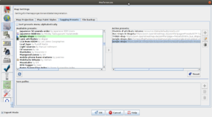
We will use the Jungle Stops preset to add in one click all main useful tags for public transport stops that have been surveyed. To activate the preset in JOSM:
- Edit -> Preferences
- Tagging presets
- Select "Jungle stops"
Restart JOSM.
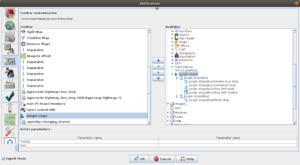
The presets are now available in JOSM presets menu. For easier access, you can add them as buttons in JOSM interface in
- Edit -> Preferences
- Toolbar
Plugins
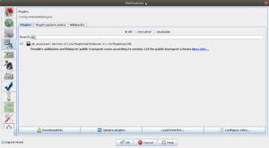
We will use JOSM/Plugins/PT_Assistant. To activate this plugin:
- Edit -> Preferences
- Plugins
- Search for "pt_assistant"
- click on "update plugins"
Validators
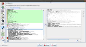
We will use both the Jungle Bus validators (generic rules about public transport objects) and some rules specifics to our project. To add them to JOSM:
- Edit -> Preferences
- Data validator
- Tag Checker Rules (2nd tab)
- Select "Jungle Bus – validation ruleset"
- Then, click on the "+" symbol
- add "Kochi Transport" in the first field
- add "https://raw.githubusercontent.com/Jungle-Bus/transport_mapcss/kochi/kochitransport.validator.mapcss" in the second field
Filters
Optional filters to hide OSM elements that we won't need to update:
- Edit -> Preferences and click the "Expert mode" at the bottom of the windows. Click OK.
- Windows -> Filters (to add the filters panel in JOSM)
- Add filter
- Type "*[highway],node[amenity=taxi],*[public_transport],*:new"
- Select "Mapcss selectors" as search syntax
- Submit filters
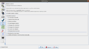
Remote control
We will need the JOSM remote control:
- Edit -> Preferences
- Remote control
- "Enable remote control"
- OK
Quality Assurance
To ensure quality of the data in JOSM, we will rely on the following validators:
- PT_Assistant plugin tests
- Jungle Bus validation ruleset
- the custom tests of the project
To set up JOSM to use these tests, follow the instructions ;)
Most of these tests can also be seen on the web using Osmose QA:
- list: http://osmose.openstreetmap.fr/en/issues/open?country=india_kerala&item=9014,1260,2140,8040
- map: http://osmose.openstreetmap.fr/en/map/#country=india_kerala&item=1260%2C2140%2C9014%2C8040&zoom=11&lat=9.9884&lon=76.4123&level=3&tags=&fixable=
Mappers
The project has been listed on the Organized Editing Activities page.
Geominds coordinating the field level data collection and mapping in OpenStreetMap. You can reach Manoj Karingamadathil (Project Lead) email - dartermanoj[at]gmail[dot]com for any queries/issues.
- jothish_geominds
- Jinoy_geominds
- yaseen_geominds
- vipindas_geominds
- vishnu_geominds
- ananthu_geominds
- abdulla_geominds
- amitha_geominds
- manoj_geominds & manojkmohan
- arkArjun
The Jungle Bus team may also make some edits:
Annoucements
- Public call for Mappers, OSM Kerala Telegram Group, Twitter, Linkedin
- Organized Editing, OSM Kerala Telegram Group
