JA:土地表面
英語版の記事の内容が分かる方は、翻訳の完成にご協力ください。このウィキの翻訳方法についての説明をお読みください。
現時点では、誰もこの記事の翻訳に取り組んでいないようですので、あなたが取り組めます。

|
| 説明 |
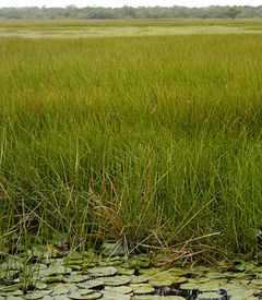
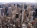
| 表面や地面の物理的な素材を記述するために使います。土地表面には草、アスファルト、樹木、土、水などがあります。 |
| タグ |
landcover は土地の表面の物理的な材質を記述するために使います。土地表面には grass(草), asphalt(アスファルト), trees(樹木), bare ground(土), water(水), などがあります。これは、landuse=farm, landuse=retail, landuse=quarry のような人による土地の利用を記述する土地利用と区別してください。
現在、 landcover のタグ付けはふつう他のタグに含まれています。例えば、公園は草でおおわれていると想定されます。しかし、場所によっては木や砂や他のものに覆われていることもあります。以下のキーは landcover 属性を暗黙に仮定したり定義したりします。
- landuse=* - 土地利用の多くは、その表面が何で覆われているかを含意しますが (たとえば landuse=meadow)、そうでないものもあります (たとえば landuse=military)。それが曖昧なものもあります。たとえば landuse=greenfield, は何らかの植物に覆われているか更地であるかのどちらかであることを含意します。土地利用と同様のことが、amenity=* や leisure=* や tourism=* にもあります。
- surface=* - 表面の材質をあらわします。土地表面と似た属性ですが、これは元々は経路ネットワークに含まれる線形の地物の表面について記述するために作られたタグであり、そういった目的に合った値をつけることが想定されています。また、これはより広い範囲を持った土地利用の表面のタイプを表すにも使われますが、主に副次的なタグとして使われます。
- natural=* - このキーのタグの多くは、その表面が何で覆われているかを含意するような自然の地物をあらわします。しかし、一部のタグは natural=beach や natural=fell のように表面が何で覆われているかを明確に含意しないため、surface=* などのタグでより厳密な情報を持たせる必要があります。
- landcover=* - このタグは、土地表面を直接表現するため、Proposed features/landcover で提案されました。
森林は土地表面をマッピングしにくいでしょう。 詳しくはJA:森林をお読み下さい。 There is not currently a good tag to describe a landcover of trees as opposed to a landuse of timber production for which landuse=forest is appropriate or natural=wood for primary unmanaged woodland. The tag landcover=trees has been proposed for this purpose. In addition, landuse and landcover are often confused. For example landuse=grass actually describes a landcover, not a use. This causes problems as one can not describe an area of railway land as being primarily covered with grass as the landuse tag is used for both purposes.
現在の土地表面タグ付けの例
以下の表はかなり不完全です。追加をお願いします。この表はヘッダをクリックすると並び替えられます:
| Purpose | Category | Comment |
|---|---|---|
| 泥炭地(湿原) | Natural | natural=wetland and wetland=bog |
| Bare earth | ||
| 草原 | Natural | Currently landcover is implied by the use of landuse=grass, leisure=park, surface=grass, landuse=meadow, natural=grassland, etc. It is typical that landuse=grass is misused and should be changed to landcover=grass (for example: patches of grass between tracks in railway corridor - area that should be tagged with landuse=railway). |
| 砂利 | Natural | surface=gravel |
| Marsh | Natural | natural=wetland and wetland=marsh |
| マングローブ | Natural | natural=wetland and wetland=mangrove |
| 泥 | Natural | natural=mud |
| Reedbed | Natural | natural=wetland and wetland=reedbed |
| Saltmarsh | Natural | natural=wetland and wetland=saltmarsh |
| 砂地 | Natural | natural=sand |
| やぶ | Natural | natural=scrub |
| 海 | Natural | The natural=coastline tag is used to define the boundary between land and the sea (at the high water mark). The boundary between the land and the sea is rich in different landuses, see 'gravel', 'mangrove', 'saltmarsh', 'sand', 'swamp' and 'tidal flat'. |
| Swamp | Natural | natural=wetland and wetland=swamp |
| Tidal flat | Natural | natural=wetland and wetland=tidalflat |
| Trees | Natural | Currently the landuse=forest or natural=wood are used but neither of these work well for planted and managed trees in a park for example. |
| 水辺 | Natural | waterway=riverbank,natural=water,man_made=reservoir. See also: 'sea'. |
Proposals
Systems of Landcover classification
The landcover classification systems mentioned in the following are all based on the notion that all land surface can be classified into a limited set of landcover classes, either a fixed a priori classification or a dynamic set of a certain number of classes. Since OpenStreetMap uses a globally uniform but open tagging system - see 何でも好きなタグを - neither of these can be directly translated into OSM tag combinations.
A priori and a posteriori systems
In an a priori classification system the classes are abstractions of the types actually occurring. The approach is based upon definition of classes before any data collection actually takes place. This means that all possible combinations of diagnostic criteria must be dealt with beforehand in the classification. The main advantage is that classes are standardized independent of the area and the means used. The disadvantage, however, is that this method is rigid, as some of the field samples may not be easily assignable to one of the pre-defined classes.
A posteriori classification differs fundamentally by its direct approach and its freedom from preconceived notions. The approach is based upon definition of classes after clustering similarity or dissimilarity of the field samples collected. The advantage of this type of classification is its flexibility and adaptability compared to the implicit rigidity of the a priori classification. The a posteriori approach implies a minimum of generalization. This type of classification better fits the collected field observations in a specific area. At the same time, however, because an a posteriori classification depends on the specific area described and is adapted to local conditions, it is unable to define standardized classes. Clustering of samples to define the classes can only be done after data collection, and the relevance of certain criteria in a certain area may be limited when used elsewhere or in ecologically quite different regions.
NLCD92 - National Land Cover Database
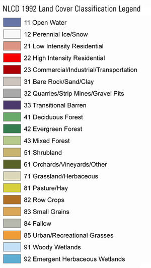
National Land Cover Database (NLCD) is a land cover classification scheme that has been applied consistently across all 50 United States and Puerto Rico. NLCD is based primarily on Landsat satellite data.
| Main class | Sub-classes | Picture |
|---|---|---|
| Water | 11 Open Water 12 Perennial Ice/Snow |

|
| Developed | 21 Low Intensity Residential 22 High Intensity Residential 23 Commercial/Industrial/Transportation |

|
| Barren Land | 31 Bare Rock/Sand/Clay 32 Quarries/Strip Mines/Gravel Pits 33 Transitional |

|
| Forested Upland | 41 Deciduous Forest 42 Evergreen Forest 43 Mixed Forest |

|
| Shrubland | 51 Shrubland | 
|
| Non-Natural Woody | 61 Orchards/Vineyards/Other | 
|
| Herbaceous Upland Natural/Semi-natural Vegetation | 71 Grasslands/Herbaceous | 
|
| Herbaceous Planted/Cultivated | 81 Pasture/Hay 82 Row Crops 83 Small Grains 84 Fallow 85 Urban/Recreational grasses |

|
| Wetlands | 91 Woody Wetlands 92 Emergent Herbaceous Wetlands |

|
| See USGS landcover classes. | ||
LCCS - Land Cover Classification System
The Land Cover Classification System (LCCS) is the result of an initiative to take a first step towards an internationally agreed reference base for land cover. The objectives of the Africover Programme of the Environment and Natural Resources Service (SDRN), FAO, are to develop an approach for conceptualizing, defining and classifying land cover.
Definition: Land cover is the observed (bio)physical cover on the earth's surface.
One of the basic principles adopted in the new approach is that a given land cover class is defined by the combination of a set of independent diagnostic attributes, the so-called classifiers. There are 83 main classifiers (Type A), 13 Type B, 19 Type C, 3 Type D, 7 Type E, 10 Type F, 2 Type G (numbers are not approved).
The creation of the land cover class is given by the combination of a set of pre-defined pure land cover classifiers. This set of classifiers is different for each of the eight main land cover types. E.g. trees can have classifier A1 or A3; shrubs can have A2 or A4; B1 stands for large to medium sized fields or height 7-2m or Dunes.
The main criteria is the uppermost canopy layer. This means that the dominant layer goes from Tree canopy to Shrub to Herbaceous/Forbs/Graminoids.
The user can describe up to three layers of stratification (including the main layer) for Terrestrial Vegetation (A12) and up to two layers in Aquatic or Regularly Flooded Vegetation (A24). "Tree Savannah" is clearly defined by two main elements: a Herbaceous vegetation layer and a Sparse Trees layer. Thus, the Stratification of the two elements Herbaceous and Tree layer is crucial for the definition of this class. "Closed Forest" is clearly defined by the element of a Closed Trees layer. Limitations have been introduced for this class in the use of Stratification. All limitations in use of Stratification are built into the software application.
It is crucial where the classifier (e.g. trees) appears, in the main layer or second or third layer.
Examples for results of LCCS-Code in main type A12. Natural and Semi-Natural Vegetation:
- A3.A10 - Closed forest
- A3.A10.B2.C1.D1.E2 - Broadleaved dedicious forest
- A3.A10.B2.C1.D1.E2.F2.F5.F7.G2 - Multi-layered broadleaved dedicious forest
- this combinations have a completely different meaning in other main types
| Main types | Classifier | Classifier | Classifier | Picture | Some possible results after classification |
|---|---|---|---|---|---|
| A11. Cultivated and Managed Terrestrial Areas | A1. Trees | A7. Broadleaved | Leaf Phenology | 
|
Tree Crops Shrub Crops Herbaceous Crops Graminoid Crops Non-Graminoid Crops Managed Lands |
| A8. Needleleaved | Leaf Phenology | ||||
| A2. Shrubs | A7. Broadleaved | Leaf Phenology | 
| ||
| A8. Needleleaved | Leaf Phenology | ||||
| A3. Herbaceous | A4. Graminoids | 
| |||
| A5. Non Graminoids | 
| ||||
| A6. Urban vegetated areas | A11. Parks | ||||
| A12. Parklands | |||||
| A13. Lawns | 
| ||||
| A12. Natural and Semi-Natural Vegetation | A1. Woody | A3. Trees | Cover Height Leaf type Leaf Phenology |

|
Forest Woodland Thicket Shrubland Grasslands Sparse Vegetation Lichens/Mosses |
| A4. Shrubs | Cover Height Leaf type Leaf Phenology |

| |||
| A2. Herbaceous | A5. Forbs | 
| |||
| A6. Gramminoid | 
| ||||
| A7. Lichens/Mosses | A8. Lichens | ||||
| A9. Mosses | |||||
| A23. Cultivated aquatic or regulary flooded areas | A1. Graminoids | Aquatic Or Regularly Flooded Graminoid Crops Aquatic Or Regularly Flooded Non-Graminoid Crops | |||
| A2. Non graminoids | 
| ||||
| A3. Woody | |||||
| A24. Natural and Semi-Natural Aquatic or Regularly Flooded Vegetation | A1. Woody | A3. Trees | 
|
Forest Woodland Closed Shrubs Open Shrubs Grasslands Sparse Vegetation Lichens/Mosses | |
| A4. Shrubs | |||||
| A2. Herbaceous | A5. Forbs | ||||
| A6. Gramminoid | 
| ||||
| A7. Lichens/Mosses | A10. Lichens | ||||
| A11. Mosses | |||||
| B15. Artificial Surfaces and Associated Areas: | A1. Built-up | A3. Linear | A7. Roads | 
|
Built-Up Areas Non Built-Up Areas |
| A10. Railroads | 
| ||||
| A11. Pipelines | 
| ||||
| A4. Non Linear | A12. Industrial Areas | 
| |||
| A11. Urban Areas | 
| ||||
| A2. Non built-up | A5. Waste dump deposits | ||||
| A6. Extraction sites | 
| ||||
| B16. Bare Areas | A1. Consolidated | A3. Bare Rock a/o Coarse Fragments | A7. Bare Rock | 
|
Consolidated Areas Unconsolidated Areas |
| A8. Gravel | 
| ||||
| A4. Hardpans | A9 Ironpan A10 Petrocalcic A11 Petrogypsic |

| |||
| A2. Unconsolidated | A5. Bare Soil | Not stony | 
| ||
| A12. Stony | |||||
| A13. Very stony | 
| ||||
| A6. Loose and shifting sand | Not stony | 
| |||
| A12. Stony | |||||
| A13. Very stony | 
| ||||
| B27. Artificial Waterbodies, Snow and Ice: | A1. Artificial Waterbodies | A4. Flowing | 
|
Artificial Waterbodies Artificial Snow Artificial Ice | |
| A5. Standing | 
| ||||
| A2. Artificial Snow | |||||
| A3. Artificial Ice | |||||
| B28. Natural Waterbodies, Snow and Ice: | A1. Natural Waterbodies | A4. Flowing | 
|
Natural Waterbodies Natural Snow Natural Ice | |
| A5. Standing | 
| ||||
| A2. Natural Snow | 
| ||||
| A3. Natural Ice | 
| ||||
| See Land Cover Classification System (LCCS). | |||||
