JA:Key:CEMT
Jump to navigation
Jump to search
| 説明 |
|---|
| ヨーロッパにおける内陸の水路の分類です |
| グループ: 制限 |
| 適用できる要素 |
| よく併用されるタグ |
| 状態:事実上の標準 |
| ツール |
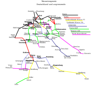
CEMTはヨーロッパにおける内陸の水路の分類です。
水路
Classification
| Seamark / iENC ... : category |
CEMT-Class/Value | max. Length | max. Width | max. Draught | Height | Remark |
|---|---|---|---|---|---|---|
| 1 | 0 | - | - | - | - | inofficial, used in NL for recreational boating fairways |
| 2 | I | 38,50 | 5,05 | 1,8-2,2 | 4 | of regional importance |
| 3 | II | 50-55 | 6,6 | 2,5 | 4-5 | of regional importance |
| 4 | III | 67-80 | 8,2 | 2,5 | 4-5 | of regional importance |
| 5 | IV | 80-85 | 9,5 | 2,5 | 5,25-7 | of international importance |
| 6 | Va | 95-110 | 11,4 | 2,5-4,5 | 5,25-7 | of international importance |
| 7 | Vb | 172-185 | 11,4 | 2,5-4,5 | 5,25-9,1 | of international importance |
| 8 | VIa | 95-110 | 22,8 | 2,5-4,5 | 7-9,1 | of international importance |
| 9 | VIb | 185-195 | 22,8 | 2,5-4,5 | 7-9,1 | of international importance |
| 10 | VIc | 193-200 | 34,2 | 2,5-4,5 | 9,1 | of international importance |
| 11 | VII | 195/285 | 34,2 | 2,5-4,5 | 9,1 | of international importance |
Inland waterways are ![]() navigable if one of theses tags are used :
navigable if one of theses tags are used :
Navigable waterways are rendered in dark green on the fluv.io map.
An other example: European Navigable Waterways
情報源
- mapserver (also wms) rijkswaterstaat.nl (add 'VIN' layer)
- wms-server and pdf-map wsv.de
- VNF maps server site vnf
- Pdf map of french waterways site vnf
- IENC map site vnf
関連項目
リンク
注釈
- European Conference of Ministers of Transport (12 June 1992). Resolution No. 92/2 on New Classification of Inland Waterways.


