JA:Key:lock
Jump to navigation
Jump to search
| 説明 |
|---|
| 水門で囲まれた、閘門を形成する水路の部分を示します。 |
| グループ: 水域 |
| 適用できる要素 |
| よく併用されるタグ |
| 状態:承認 |
| ツール |
この記事は翻訳記事ですが、翻訳が不完全であり、抜けや誤り、未翻訳の部分があります。
英語版の記事の内容が分かる方は、翻訳の完成にご協力ください。このウィキの翻訳方法についての説明をお読みください。
現時点では、誰もこの記事の翻訳に取り組んでいないようですので、あなたが取り組めます。
英語版の記事の内容が分かる方は、翻訳の完成にご協力ください。このウィキの翻訳方法についての説明をお読みください。
現時点では、誰もこの記事の翻訳に取り組んでいないようですので、あなたが取り組めます。
A lock is a device used for raising and lowering boats, ships and other watercraft between stretches of water of different levels on river and canal waterways
How to map
Small lock
- 1. Lock
Separate the way ![]() of the waterway=* at the two lock gates. Mark the newly created section with
of the waterway=* at the two lock gates. Mark the newly created section with
- 2. Gate of a lock
Place two nodes ![]() on the main flow line (waterway=*), where the upper and lower sluice gate is located and mark both
on the main flow line (waterway=*), where the upper and lower sluice gate is located and mark both
- 3. Channel or river
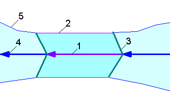
Large lock

Example: West India Dock Entrance Lock
- 1. Lock
Separate the way ![]() of the waterway=* at the two lock gates. Mark the newly created section with
of the waterway=* at the two lock gates. Mark the newly created section with
- 2. Lock chamber
- 3. Gate of a lock
- 4. Channel or river
- 5. Riverbank
タグ付け
- maxwidth=*
- maxlength=*
- draft=*
- lock_ref=*
- lock:height=*
- automated=yes
- self_service=yes
- opening_hours=*
- boat=*
- ship=*
- CEMT=*
- seamark:gate:category=* + seamark:type=gate
- seamark:gate:clearance_height=* + seamark:type=gate
- seamark:gate:clearance_width=* + seamark:type=gate

