JA:Tag:landuse=reservoir
Jump to navigation
Jump to search
この地物は非推奨とされています。 置き換えは natural=water+water=reservoir が推奨されています。
理由は Deprecated features に書かれています。 OpenStreetMap には「禁止の地物」がありませんので、使い続けたり合うように解釈したりするのは自由です。
どのような場合でも、JA:Automated Edits code of conduct による承認なしに、データベース内にあるこのタグを別なタグに自動的(または半自動的)に置き換えるべきではありません。 そのような編集は取り消されます。
理由は Deprecated features に書かれています。 OpenStreetMap には「禁止の地物」がありませんので、使い続けたり合うように解釈したりするのは自由です。
どのような場合でも、JA:Automated Edits code of conduct による承認なしに、データベース内にあるこのタグを別なタグに自動的(または半自動的)に置き換えるべきではありません。 そのような編集は取り消されます。
| 説明 |
|---|
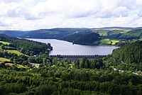
| 貯水池。水を貯めるための人工的な湖です。 |
| OSM Cartoでのレンダリング |

|
| グループ: 土地利用 |
| 適用できる要素 |
| よく併用されるタグ |
| 関連項目 |
| 状態:非推奨 |
| ツール |
このタグは廃止の提案がされています。詳しくはproposal pageをご覧ください。提案へのコメントはtalk pageから行ってください。
貯水のために人工的に作られた場所です。覆いがある場合もない場合もあります。
landuse=reservoir が非推奨かどうかについては混乱が予想されていましたが、非推奨ではないという結果になり、 landuse=reservoir は「新しい」方法である natural=water + water=reservoir よりもはるかに広く使われています。
実際の水域を landuse=reservoir の代わりに(あるいは併用で) natural=water + water=reservoir でタグ付けするのは良い方法です。承認された水域の詳細情報の提案と議論ページの議論を参照してください。
今のところ、多くのレンダラーが landuse=reservoir を見える水域として解釈し、描画します。
タグ付け方法
まずノードか閉じたウェイを地図上に描き、タグをつけます。
| タグ | 解説 |
|---|---|
| landuse=reservoir | 貯水のために人工的に作られた場所。 |
正確を期すためにしばしば下記のタグを追加します。
| タグ | 解説 |
|---|---|
| name=* | 分かるならば、貯水池の名前。 |
| covered=yes/no | 覆いがあるかどうか[1]。覆いがある場合は通常地下に埋設されている。 |
| intermittent=yes | 季節的または間欠的にしか水が存在しない場合。 |
| natural=water + water=reservoir | 貯水池が解放水域(覆いがない)ならば、追加することができます。 |
| reservoir_type=* | 貯水池の用途を説明します。 |
提案
water=reservoir
- 水域の詳細情報の提案は承認され、代替となるタグ付け natural=water + water=reservoir が示されています。
- Main advantage of a new tagging scheme is that all water (except oceans) can be queried with natural=water tag, which simplifies using OpenStreetMap data in some cases.
- Note that synonyms are a minor problem while using OpenStreetMap data and, while irritating, are not a major barrier
- This benefit will happen only after the alternative tagging is gone: as long as many reservoirs are tagged as landuse=reservoir without natural=water, data consumers must support also landuse=reservoir anyway.
- If someone wants to select only some specific types of water areas or have different rendering depending on a type of water area, this benefit completely disappears.
- First disadvantage is that this change requires changing tagging behaviour from mappers, rewriting software, documentation, training materials etc.
- Second disadvantage of water=reservoir is that is discourages people to understand different classes of water and therefore is a problem when learning cartography
- Third disadvantage of water=reservoir is that it added a duplicate schema which maps exactly the same classes of water object classes
- Note that the proposal included a very confusing section. It was titled "deprecation" and had "landuse=reservoir (replaced by natural=water + water=reservoir)" but also included text which made it unclear:
- Redefined deprecated: ""Deprecates" means "is equivalent for all purposes to""
- "we don't want massive retagging and edit wars."
- Main advantage of a new tagging scheme is that all water (except oceans) can be queried with natural=water tag, which simplifies using OpenStreetMap data in some cases.
貯水池として利用されている土地のタグ付け
- メールによる議論で、貯水池に関するエリアやオブジェクトに対応したタグ付け方法(現在の定義のスーパーセット)を作成してほしいという意見が明確にありました。この目的で landuse=reservoir を使用することは論理的であるかのように見えましたが、これは現在広く使われている定義と競合することから、代わりに他のタグ付け方法の提案が求められています。貯水池周辺の制限された土地については、 landuse=reservoir_watershed の使用を検討してください。
関連情報
- water=reservoir + natural=water - このタグは landuse=reservoir と同じとみなされます。
- man_made=reservoir_covered - 覆いのある貯水池
- landuse=salt_pond - 塩田。塩の蒸発池や製塩所
- water=pond - 静止した小さな水域で、多くの場合は人造
- landuse=reservoir_watershed - 水質を守るために貯水池の周辺に設置された土地
- leisure=swimming_pool - 人工の水泳プール
- natural=water+ water=lake - 自然の、またはそれに準じる湖
- water=*
- waterway=dam
- waterway=weir
- man_made=storage_tank
外部リンク
- Apr 2021 [forum-nl] - Reservoir?
- Dec 2020 [wiki] Proposed features/Reservoir - new proposal, attempts to deprecate landuse=reservoir
- Dec 2020 [wiki] Popularity patterns of reservoir tagging on areas
- Dec 2020 [tagging] The saga of landuse=reservoir vs water=reservoir - tagging mailing list, 2020 thread
- Nov 2020 [tagging] deprecate water=pond?
- Jul 2020 [tagging] Riverbanks
- Mar 2020 [tagging] Ponds are not observable on the ground
- Nov 2019 Changeset 76766631 discussion (author: pangoSE)
- Jul 2019 [JOSM ticket] Proposal to introduce the same retagging rule into JOSM
- Jun 2019 [talk] iD forces mistagging again
- Jun 2019 [talk-lt] iD redaktoriaus problemos (iD editor problems)
- Jun 2019 [tagging] landuse=reservoir vs water=reservoir
- Jun 2019 [iD github] iD is forcing retaging from landuse=reservoir to natural=water+water=reservoir
- Apr 2019 [talk] iD influencing tagging
- Oct 2018 [talk-it] landuse=reservoir
- Sep 2018 [tagging] My weirdly unnatural aversion to relations
- Jul 2018 [tagging] landuse=basin
- Mar 2017 [tagging] water=pool
- Jun 2016 [talk] Failed water proposal reversal
- Feb 2015 [tagging] How to tag a cistern?
- Jan 2015 [tagging] Adding water=fishpond to the wiki
- Jun 2013 [tagging] When was landuse=reservoir deprecated?
- Jun 2013 [JOSM ticket] Reservoir preset is using a deprecated tag
- Nov 2012 [talk-it] Tag:landuse=reservoir
- May 2012 [talk-lt] Vandens telkiniai (Water bodies)
- Jan 2012 [tagging] Health and other stories
- Sep 2011 [tagging] water=*
- May 2011 [tagging] Requirements for proposals and voting to be valid
- Apr 2011 [tagging] New proposal: water=* (voting announcement)
- Apr 2011 [tagging] New proposal: water=*
- Mar 2011 [wiki] Proposed features/Water details
- Jan 2008 [talk] RFC - lake
