Key:building:levels
| Description |
|---|
| The number of above ground levels in the building facades. |
| Group: buildings |
| Used on these elements |
| Requires |
|
| Useful combination |
| See also |
| Status: de facto |
| Tools for this tag |
|
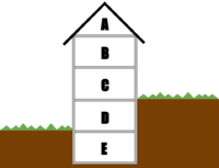
The building:levels tag is used for marking the actual number (see value section) of above-ground levels (= floors = storeys) of a building (building=*) or part of a building (building:part=*). The underground levels and the roof do not count as levels here. However, levels that are part-way underground do count (see example below).
It can be useful to also add height=*, especially if the height per level is different for each building part. Keep in mind that height=* includes the roof, while building:levels does not.
Examples
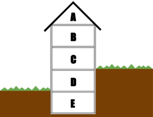
- D (ground level, level=0), C (first floor, level=1) + B (second floor, level=2) counts as building:levels=3
- E (underground level, level=-1) counts as building:levels:underground=1
- A (roof level, level=3) counts as roof:levels=1
A building (part) with only one ground level will be tagged with building:levels=1.
A building full in the ground (for example an archeological tomb like at ![]() Tierradentro) will be tagged with building:levels=0 + building:levels:underground=1.
Tierradentro) will be tagged with building:levels=0 + building:levels:underground=1.
Buildings with parts that don't start at ground level
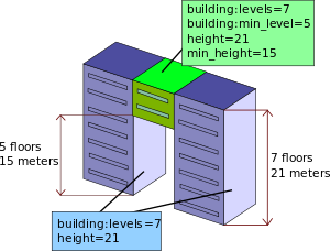
If a building part does not start at the ground level, building:levels=* should include the number of skipped levels below the building part (i.e the number of levels that would exist if the space between the ground and the bottom of the building part were filled with levels of the typical height for this building). The key building:min_level=* should be used to describe the number of skipped levels in this building part.
It is therefore imperative that building:levels=* is always strictly greater than building:min_level=*.
Values
Values should be a positive integer number. Fractional values (like 1.5) are not valid (what is the meaning of a 0.5 floor?) and probably means that the mapper diverted the tags *:levels to express a height instead of using the appropriate tags. The usual dimension is a height of 3 meters for each floor (default floor height used for 3D renderings when the height tags are not specified). Use height and roof:height if a building has unusual dimensions. For example, use building:levels=1 and height=4.5 if the building has one 4.5 m high floor instead of building:levels=1.5.
The height of buildings (in meters) is usually difficult to determine if there is no right data, e.g. from a cadastre. But the default value of 3 meters for one floor is probably a good approximation of the actual height, if you don't know it, for most of the buildings. So you don't need to add the height tags for a normal 4-storey building. If floors are clearly larger or smaller than the default value (for example a sport hall 6 meters high, or a small shelter 2 meters high, or a 4-storey retail building higher than a 5-storey residential building), use the tags height or/and roof:height.
For a better understanding, see Simple_3D_Buildings#Usage_of_height,_roof:height,_building:levels,_roof:levels.
The number of levels is a relative value – you know only how many levels a building has and when drawing building:parts, you give their relative number of levels in relation to the whole building.
Renderer Support

Renderers which take building:levels=* into account.
- Organic Maps - Android App, renders building height based on building:levels=*, when height=* is not set
- F4 Map - Web Service, renders building height based on building:levels=*, when height=* is not set
- OSMBuildings - Web Service, renders floors as windows
- OSM2World - Java Application, renders floors as windows
See also
- roof:levels=* – Number of levels in the roof of a building
- building:levels:underground=* – Number of levels below ground level
- building:min_level=* – Number of values under the bottom of the building (part), "filling" space between ground level and bottom level of building or part of building
- level=* – Floor number of a feature
- height=* – Total height of an element (building, tree, tower...) from the ground to the highest point
- min_height=* – Height of location of bottom part of a building, part of building or another object
- Simple 3D Buildings
- Sophox query for average building heights by floor count
- Simple Indoor Tagging


