Key:fire_hydrant:position

From OpenStreetMap Wiki
Jump to navigation Jump to search
Public-images-osm logo.svg fire_hydrant:position
Description
Position where to find the fire hydrant (lane, parking_lot, sidewalk, green) Edit this description in the wiki page. Edit this description in the data item.
Group: emergencies
Used on these elements
may be used on nodesshould not be used on waysshould not be used on areasshould not be used on relations (except multipolygon relations)
Requires
Status: in use

Defines the position, where a emergency=fire_hydrant can be found.

Values

Value Description Example
green The hydrant is to be found surrounded by greens, e.g. it is located in a grass patch. Fire hydrant in grass.jpg
sidewalk The hydrant is on a sidewalk. Fire hydrant on sidewalk 2.jpg
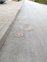
lane The hydrant is on the side of a road lane. Fire hydrant on road side.jpg
parking_lot The hydrant is in a parking. Fire-fighting-facility node-4279866277.jpg

Possible tagging mistakes

If you know places with this tag, verify if it could be tagged with another tag.
Automated edits are strongly discouraged unless you really know what you are doing!
If you know places with this tag, verify if it could be tagged with another tag.
Automated edits are strongly discouraged unless you really know what you are doing!
If you know places with this tag, verify if it could be tagged with another tag.
Automated edits are strongly discouraged unless you really know what you are doing!
If you know places with this tag, verify if it could be tagged with another tag.
Automated edits are strongly discouraged unless you really know what you are doing!
If you know places with this tag, verify if it could be tagged with another tag.
Automated edits are strongly discouraged unless you really know what you are doing!
If you know places with this tag, verify if it could be tagged with another tag.
Automated edits are strongly discouraged unless you really know what you are doing!