Korea bridges
How to map
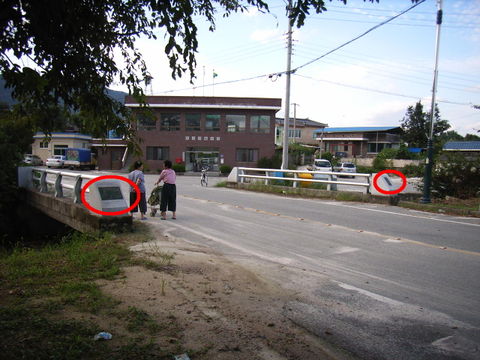
You can follow the basic instructions in the main wiki, but in Korea there is usually a lot of information about the bridge on a plaque on the bridge itself which we can record.
The name plaque
This name plaque includes Hanja (Chinese) characters as well has Hangul (Korean) characters. We need the Hangul for the name=* and name:ko=* tags. In this example the name of the bridge is 갈지교. Add the Hanja like this: name:zh=* (if you don't know how to type it, you can use a web tool. Optionally you may add a foreign translation, for example English. It is not advised to do so, because this translation can be made by the renderer or data consumer algorithmically. 교 is Korean for bridge, so in English this is Galji Bridge.
For this example bridge the tags are:
name=갈지교
name:ko=갈지교
name:ko-Latn=Galjigyo
name:zh=葛旨僑
name:en=Galji Bridge (optional, not recommended)
The information plaque
There is a lot of information here. We can see the length (총연장) and width (교폭) of the bridge (in metres), the weight limit (in tonnes) and the construction dates (공사기간).
The weight limit is not shown in this example.
The information from this photo can be tagged as follows:
length=10.0
width=11.0
construction_start_date=2003-05-09
construction_end_date=2004-12-09
Colliding name tags of way and bridge
Note that there is only one name=* tag, so if the bridge has a name and is on a named road the name of the bridge takes precedence. This is being addressed by two proposals: one introduceing the key bridge_name and alternatively one using relations instead.
Remains from imports
There are a lot of bridges which have been imported in South Korea. Most of them are not verified and are instead of a segment of the road/train/path they are single points of data not connected to the road. Sometimes there are two points, one for the beginning and one for the end of the bridge. To fix this, there is a proposal for a maproulette challenge.

