Tag:landuse=railway
| Description |
|---|
| An area of land dedicated to train operation or support, around tracks, yards, sidings, station complexes, and ancillary man-made objects along the tracks. |
| Rendering in OSM Carto |

|
| Group: railways |
| Used on these elements |
| Useful combination |
|
| See also |
| Status: approved |
| Tools for this tag |
|
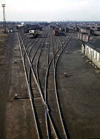
Use landuse=railway to map areas of land used for railway transport (commonly known as the railway corridor): the area dedicated to train operation or support, around tracks, yards, sidings, station complexes, and ancillary man-made objects along the tracks.
Railway land usually contains railway track, which generally consists of one or more main or branch lines, and may also include more complex track configurations such as marshalling yards for freight and/or passenger rolling stock, locomotive depots, railway stations and sidings owned by the railway company. Railway land also contains the buildings such as workshops, washing plants, coaling and water towers, railway station complexes and other infrastructure that support the operation and maintenance of rolling stock. In addition railway land may also contain artefacts of railway operation and maintenance occasionally found alongside operational railway track, including piles of coal, ballast and sleepers and derelict rolling stock, in addition to abandoned or derelict railway track.
