LatAm/Events/Mapatón AniversarioXIII OSM/Instructions
Instructions for Brazil, in english
- Introduction:
Welcome!
The focus of this project is to map basic elements: streets and buildings,
inside informal settlement areas (such as small villages, slums, and similar irregular occupations). There's few public data about the interiors of these areas.
To map properly, please read carefully the following brief instructions.
This mapping is relatively simple, but it requires care and attention.
Thank you!
- Instructions:
Firstlyː when opening the editor, check in the selected area if streets (highway=*) and building=* are already mapped.
A) If already mapped: do not add more data; please just mark the task as done, and then move on to others.
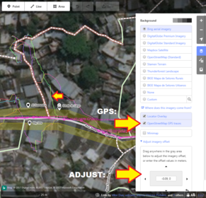
B) If streets or buildings aren't mapped: before starting, check the correct alignment of the image in the area with the GPS layer,
if available (on the right pannel of iD editor); if necessary, adjust imagery.
1) WAYS:
The focus is on the ways (streets, etc) that allow vehicles, easier to identify.
If they are already mapped: please move to the buildings (or if necessary, carefully realign already mapped ways).
If they are not yet mapped:
Map only what, and as far as, you can see clearly. If the image is not good or you can't clearly identify ways, do not map them.
Map only ways (streets, etc) that may be in at least 01 connection with other existing ways around.
Do not leave "short loose, unconnected, stretches".
Do not leave "nodes" of ways "connected" to buildings.
For ways with less than 10m radius, 03 nodes are usually enough.
Use the following tags:
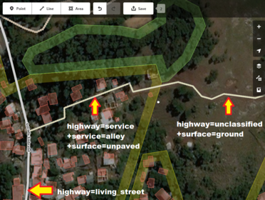
1) Narrow ways where there is sign of vehicle access: highway=service + service=alley
2) Ways where there is common access of vehicles, without sidewalk, where people transit through the vehicles: highway=living_street
3) More regular streets, with sidewalks: highway=residential
4) Ways leading to the field or outside the community: highway=unclassified
In all cases, if "unpaved", add: surface=unpaved.
2) BUILDINGS:
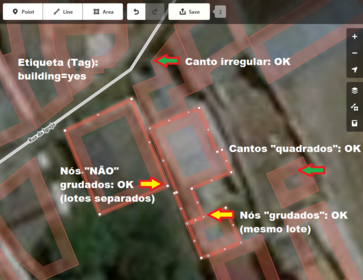
Use closer zoom to map it, following the contours of the roofs (or coverture), and tagging it with building=yes.
Take also a look on the shadows, to help on distinguishing roofs from what may be floor area or even walls.
If the image is not good and you can not identify roofs, do not map.
-If contiguous roofs are touching each other, draw them with connected nodes;
-If they are not touching each other, draw them apart, not connecting their nodes.
See some examples below. Do not hesitate to return to this instruction page while mapping. In case of mistakes, just "undo" your last editions, or cancel the edit without saving. If you need to interrupt the mapping, just save the edit, click stop on the task, leaving a comment of what you have mapped (eg: "mapped east"), for others who continue it later.
Thank you!
For any other questions or more information, please contact the Brazilian community, by email at:
https://lists.openstreetmap.org/pipermail/talk-br/
Changeset comment: #OSM_Latam #Mapatona_Assentamentos_Informais


