Mapping Quality (software)
| Mapping Quality | |
|---|---|
| Website: | https://svn.openstreetmap.org/applications/utils/gary68/mappingquality.pl |
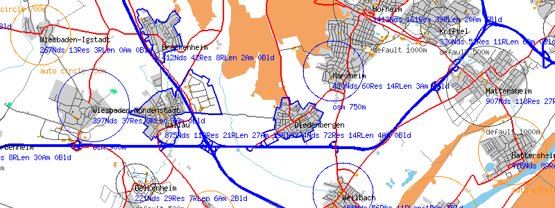
The program mappingquality.pl parses osm files for unmapped and sparsely mapped places and provides data for Slippy Unkartografiert. Furthermore it provides some statistical data of all places.
You can see the gray default circles, the orange auto sized places and the blue osm data based places (by radius or by area/way).
Statistical values
- mean number of nodes per place type
- population
- number nodes inside type distance
- number FIXME nodes
- number highway=residential
- number highway=residential without name
- length of highway=residential roads
- number highway=road
- number FIXME ways
- number amenities
- number buildings (mapped as ways, not nodes)
Output files
- input for slippy map (see above)
- HTML file for viewing
- CSV file (UTF-8) for use in Office tools like Calc or Excel. You can then process the data further.
- Graphic showing map with some numbers (node count, residential count and length, building and amenity count)
- CSV (UTF-8) List of streets per place (place name, place key, street name, street length)
For the street list the following values are considered: residential, service, living_street, unclassified, primary, secondary, tertiary.
Parameters
The program first assumes the radius per place type. See HTML output for actual values. This can be overridden by OSM data. If a place has a corresponding way (area) that is tagged as place with correct name and type or if a place has one of the following tags (keys to be precise)
- radius
- place_radius
- diameter
- place_diameter
the radius or diameter can be specified in
- meters or
- kilometers
So valid values would be
- 750 m
- 2.5 km
Examples:
- radius=200 m
- place_diameter=2 km
Additionally the program tries to identify the radius by the extension of residential streets in the vincinity.
So basically the priority for defining the radius/extension of a place is the following:
- osm data (place area)
- osm data (radius or diameter in place node)
- automatically detected (circle or other)
- defaults
The automatic function works best for mapped villages and towns. Crowded cities are not its turf.
If something is wrong with your place...
Make sure that
- your place has a place node
- your place node is tagged correctly (place=village i.e., name=name or place_name=name)
- your place size was determined automatically and correct (if not, create a place way/area)
- your place has a way surrounding it with proper tags (place=village i.e., name=name or place_name=name)
- your place way is closed! (meaning that the first node equals the last one)
- your tag values match each other so a way corresponding to a place node can be found
See also Key:place and Talk:Key:place
Results
ATTENTION
- The graphic files are VERY large. Please download first and use graphics program to display. Some browsers may have problems displaying the files.
- The CSV files are also very big. Maybe you have to use an editor first to cut them for fitting into Excel or Calc. Linuxer may use grep instead.
no current data available
Things to keep in mind
- By design a street name will only be reported once even if there are two separate streets with the same name at the same place.
- At the moment the program for performance reasons assumes that the radius of a place is not bigger than 10km (lat) and ~6km (lon). However for future or individual runs this value can be changed.
Wishes
- add position of streets to street lists
- support relations for boundary of places
- rendering of coastline/sea
- will be difficult since data/ways might be truncated and then the whole map will be flooded :-)
- Do also for Austria not only for Germany.
- it shall be done
