Midhurst Area Footpaths Party
Introduction
This is a mapping party to introduce people to the subtleties of footpath mapping, fill a few gaps in a generally well-mapped area, and enjoy some nice countryside!
When
Saturday, 16/10/10
Where
Meet at the Old Town Hall Coffee House, Market Square, Midhurst, W Sussex map (12 miles north of Chichester on the A286) at 9.45am. From the internet it looks like this venue is good but maybe busy, if it is we may move on, my mobile (nickw) is 07950 347717 so call if you are late and we're not there.
Plan
There are a few streets in the town that need doing, though the main emphasis will be on filling in the footpaths to the NE and SW of the town, gaps in a generally well-mapped area. This is an Area of Outstanding Natural Beauty close to the South Downs, with an attractive rolling landscape of fields, woods and heaths, so worth coming for the scenery alone, never mind the mapping!
"Cake"
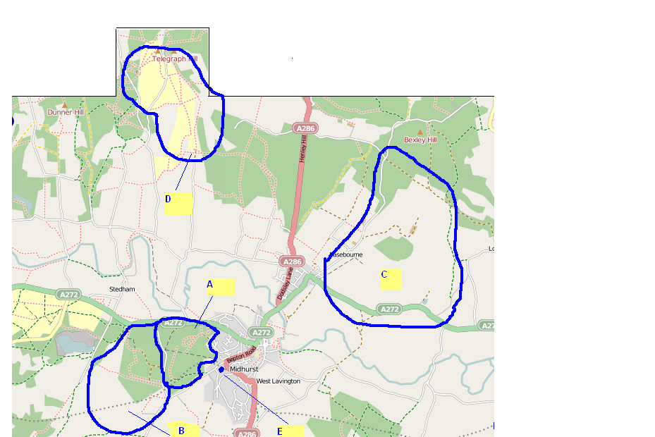
The map below shows the areas we will be focusing on. Here is a brief description:
- A - Midhurst Common: Fairly wooded area just outside the town. Dense network of official rights of way and permissive paths. Tree cover can affect signal. Needs patience! Estimated time to complete: 4 to 6 hours.
- B - The Severals: Fairly wooded area the other side of the minor road to Midhurst Common. Partly complete but a few more permissive paths present. Interestingly in the 1980s this area seemed to be completely closed to the public and even now it's not clearly shown on OS maps so this is one to show the benefits of OSM! In addition to the main wooded area there are a few more official paths to the south of this area, in open land, just west or southwest of the junction of unclassified roads shown on the map. Estimated time to complete: 3 to 4 hours.
- C - Cowdray Park: Open area, partly golf course. IIRC about 4 or 5 paths in this area, I can give advice on where I think they are on the day. Estimated time to complete: about 4 hours, more if I have forgotten some of the paths.
- D - Pound and Woolbeding Commons: Large open heathland area, National Trust, all official paths are completed but several permissive paths particularly to the south and west of this area. Great views of the Downs as this is quite a high-up area. Estimated time to complete: 4 to 6 hours.
- E - Some estate roads still doing in south Midhurst round about where the blue "blob" is. Estimated time to complete: 1 or 2 hours.
Schedule
- 0945 - 1030 approx Meet, discuss day
- 1030 - 1800 approx map, possibility of lunch depending on where people go
- 1800 onwards discuss day, drink, meal?
Party definitely happening!!
With the weather fairly settled at the moment and three definites, this party is definitely going ahead.
Sign up
Please sign up here.
nickw
monxton
