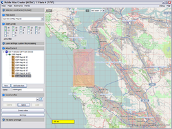
Mobile Atlas Creator
| Mobile Atlas Creator | |
|---|---|
| License: | GNU General Public License |
| Platforms: | Java ME, Linux, and Windows |
| Version: | 2.2.2 (2022-02-18) |
| Website: | https://mobac.sourceforge.io/ |
| Programming language: | Java |
|
Tiles export for lot of mobile offline nav tools | |
A unified genral Atlas exporter for a lot of mobile tools as for:
- Trekbuddy
- Magellan
- AndNav
- Glopus
- Maverick
- Mobile Trail Explorer
- NaviComputer
- OruxMaps
- OSMTracker
- Osmdroid
- Oziexplorer
- ...
MOBAC supports downloading of raster maps only and creates bundles of the tiles (atlases) for the specific platforms.
MAPANAN
MOBAC is being used by the MAPANAN project using government data and doesn't rely on the OSM servers or other 3rd parties.Here we explain a bit more how to use MOBAC without putting strain on the OSM server or using 3rd party data and instead rely solely on your own data in collaboration with your own Geoserver.
First to determine the "Selection area" we do use the OpenStreetMap tile server because it reveals to us the administrative boundaries. We do not use this to actually download the tiles and discourage anyone from doing so!
Examples
Here's the settings to be able to browse the OpenStreetMap tile server:
<?xml version="1.0" encoding="UTF-8"?>
<customMapSource>
   <name>OpenStreetMap</name>
   <minZoom>0</minZoom>
   <maxZoom>20</maxZoom>
   <tileType>png</tileType>
   <url>https://tile.openstreetmap.de/{$z}/{$x}/{$y}.png</url>
   <tileUpdate>None</tileUpdate>
   <backgroundColor>#000000</backgroundColor>
   <ignoreErrors>false</ignoreErrors>
   <serverParts></serverParts>
</customMapSource>
Please don't abuse the tile servers! Please read the Nutzungsbedingungen and tile usage policy Below is a sample how to configure MOBAC for use with your own WMS server, we use Geoserver for this purpose
<?xml version="1.0" encoding="UTF-8" standalone="yes"?>
<customWmsMapSource>
<!-- Map source name as it appears in the map sources list. Additionally, used for the tile store name -->
<name>MITD-Satellite2019</name>
<minZoom>0</minZoom>
<maxZoom>20</maxZoom>
<!-- Tile format (PNG, JPG or GIF) -->
<tileType>PNG</tileType>
<!-- WMS version. Currently, only 1.1.1 and 1.3.0 is tested -->
<version>1.3.0</version>
<!-- WMS layer parameter -->
<layers>ort%3Asatellite_2019</layers>
<!-- WMS base URL -->
<url>http://192.168.90.44:8083/geoserver/ort/wms?</url>
<!-- EPSG:4326, EPSG:4171 -> unit in degrees (default). EPSG:3857, EPSG:900913 and EPSG:3785 -> unit in meters -->
<coordinatesystem>EPSG:4326</coordinatesystem>
<!-- degree (default) - meter for EPSG:3857, EPSG:900913 and EPSG:3785 -->
<coordinateunit>degree</coordinateunit>
<!--
Optional: Additional parameters appended to the WMS url.
It is recommended to wrap any field that has special characters, such as an ampersand, inside a `<![CDATA[ ]]>` element.
Otherwise you have to use their XML encoding, such as `&`
-->
<aditionalparameters><![CDATA[&STYLES=]]></aditionalparameters>
<!-- Transparent background -->
<backgroundColor>#000000</backgroundColor>
-->
</customWmsMapSource>
We hope this information helps others to easily use their own tile servers for the use with MOBAC..
More information can be found here
MOBAC for Vespucci and OSMAnd
Both apps are being used for our project and each has it's own database, so before you click on the button Create Atlas make sure you select the right one.
- Vespucci needs MBTiles SQLite
- OSMAnd needs OsmAnd SQLite
