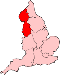
North West England
| V・T・E |
| latitude: 53.99, longitude: -3.46 |
| Browse map of North West England 53°59′24.00″ N, 3°27′36.00″ W |
| Edit map |
|
External links:
|
| Use this template for your locality |
North West England is a region in England, United Kingdom at latitude 53°59′24.00″ North, longitude 3°27′36.00″ West.

|
North West England is one of the nine official regions of England. It has a population of 6.8 million and comprises five counties of England – Cumbria, Lancashire, Greater Manchester, Merseyside, and Cheshire.
North West England (151261![]() 151261) is bounded on the west by the Irish Sea and on the east by The Pennines mountain range. The region extends from the Scottish Borders in the north to the Welsh Mountains in the south. The highest point in North West England (and the highest peak in England) is Scafell Pike, Cumbria, at a height of 978 m.
151261) is bounded on the west by the Irish Sea and on the east by The Pennines mountain range. The region extends from the Scottish Borders in the north to the Welsh Mountains in the south. The highest point in North West England (and the highest peak in England) is Scafell Pike, Cumbria, at a height of 978 m.
Two large conurbations, centred on the cities of Liverpool and Manchester, occupy the south of the region and are its largest centres of population. The north of the region, including northern Lancashire and Cumbria, is largely rural.
