Norway/Bygninger i Norge
This is a subproject of the Norway mapping project where information about mapping buildings in Norway is collected. Please help to add more information.
Import
- Main article: Import/Catalogue/Norway_Building_Import
Most buildings in Norway are already present in OSM except in the municipalities of Luster and Tysnes, where buildings need to be created manually in OSM.
Goals
- Add all buildings in Norway
- Building tags to all Buildings (building:levels or building:height)
- Simple 3D tags of all buildings
Tagging Convention
Naming the building
For a building with a shop inside the shop should be a separate node. If the shop is on the building the name of the shop becomes the name of the building. Then you get a building name i.e. "Rema 1000" when the building really has no name
Address on the building
All addresses in Norway has been imported as separate nodes to make it easy to update and maintain. It was decided that the nodes should stay separate from the buildings. See this email thread on the mailing list for detailed explanation of the reasoning.
Other sources
Kartverket N50
The N50 dataset from Kartverket contains a number of buildings. Smaller buildings are represented by nodes only. Due to generalization/simplification, the N50 building data are generally not suited for import.
Riksantikvaren
Riksantikvaren (Directorate for Cultural Heritage) has released a dataset that contains building outlines for many older buildings. Permission to import the data has been granted. The churches have already been imported. No import plan for the rest of the buildings has been made yet. More information: [1]
Imagery to draw buildings from
Norge i bilder
Norge i bilder.no has some excellent aerial photography of all of Norway that are maximum four years old. OpenStreetMap has been granted permission to use Norge i bilder: [2].
Kartverket laser scans
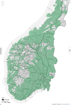
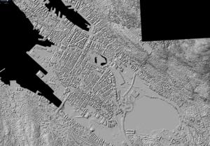
Kartverket has scanned most of Norway with LIDAR and the data is available under the NLOD (open) license. See the picture on the right for an example of the coverage.
All the imagery is available in JOSM as a WMS endpoint where the data is divided by years and then by area. To find which is available for you area, an easy way is to go to Høydedata.no, browse to your area and click it, and a pop-up will list the available imagery, and then go to JOSMs imagery menu (as instructed below) to select it.
Another way to find available imagery layer is to search (ctrl+f) for it here
To activate the imagery do this:
JOSM Top menu - Imagery - Kartverket DOM Digital Surface Model - Laser - 2014 - Oslo Byggesonen 2014
For areas other than Oslo, consult the following table:
| Area | Name of the best imagery-layer | Verified generated WMS URL |
|---|---|---|
| Bergen | Bergen 10 pkt 2016 | wms:https://wms.geonorge.no/skwms1/wms.hoyde-dom_skyggerelieff?FORMAT=image/jpeg&VERSION=1.1.1&SERVICE=WMS&REQUEST=GetMap&LAYERS=Bergen 10pkt 2016&STYLES=&SRS={proj}&WIDTH={width}&HEIGHT={height}&BBOX={bbox}
|
| Oslo | Oslo kommune Laserskanning 2017 | https://wms.geonorge.no/skwms1/wms.hoyde-dom_skyggerelieff?FORMAT=image/jpeg&VERSION=1.1.1&SERVICE=WMS&REQUEST=GetMap&LAYERS=Oslo kommune Laserskanning 2017&STYLES=&SRS={proj}&WIDTH={width}&HEIGHT={height}&BBOX={bbox}
|
| Stavanger | Stavanger 2014 | |
| Trondheim | Trondheim 2014 | |
| Kristiansand | Kristiansand 2014 | |
| Larvik | NDH Larvik 5pkt 2017 | https://wms.geonorge.no/skwms1/wms.hoyde-dom_skyggerelieff?FORMAT=image/jpeg&VERSION=1.1.1&SERVICE=WMS&REQUEST=GetMap&LAYERS=NDH Larvik 5pkt 2017&STYLES=&SRS={proj}&WIDTH={width}&HEIGHT={height}&BBOX={bbox}
|
Adding laser imagery already in JOSM
Adding laser imagery in ID
It does not support endpoint WMS or custom WMS so it is not possible (April 2018) to use them here.
Adding custom layers
To a new/custom imagery layer go to:
1. JOSM Top menu - Imagery - Imagery Preferences - +WMS (a button down to the right)
2. And then in the box that says "Verified generated WMS URL" paste in the one shown above.
3. Select a name i.e "Kartverket laser scan 2016 10 pkt Bergen"
4. Press ok
5. Now the imagery is available through the JOSM Top menu - Imagery-menu with the name you used
JOSM tools for drawings
JOSM has some powerful tools for drawing buildings.
1. Install it like this
- Start JOSM, open the preferences window (Edit→Preferences or use the toolbar icon) and select the plugins tab.

- Click on "Download List" to download the list of available plugins.
- Check the plugins you want installed.
- Click the update button. All new plugins should start downloading and installing.
- Restart JOSM. (Some Plugins work even without a restart. You will be notified, if a restart is required.)
2. See here for a intro https://wiki.openstreetmap.org/wiki/JOSM/Plugins/BuildingsTools
 B to start with buildings tool
 X to extrude building shapes as per the imagery.
 Shift+Ctrl to rotate buildings.
 Q to orthogonalize (90 degree corners) buildings
 Shift+J to merge polygons
To split the sides of the house, to extrude with x, double click with the extrude tool on the side you want to split. See JOSM Help/Action/Extrude
3. Or here for a quick demonstration https://wiki.openstreetmap.org/wiki/JOSM/Plugins/BuildingsTools


