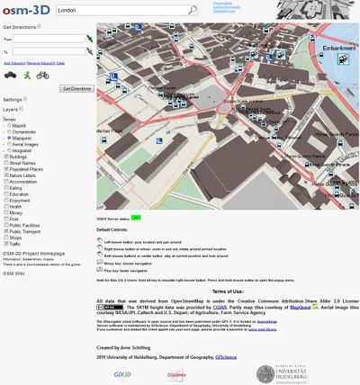
OSM-3D Applet
The OSM-3D applet is installed on the osm-3d.org home page (http://www.osm-3d.org/map.htm) and provides a simple way to view and share the contents of OSM-3D.
URL Parameters
The applet can be configured using URL parameters. The view can be centered on a specific location using the lat, lon and zoom parameters. A more extensive configuration can be realized using the B64 context parameter. lat, lon, and zoom will override the viewpoint setting in B64.
| Parameter | Description | Example |
|---|---|---|
| B64 | Context document encoded in Base64 binary format. The context describes the client configuration, including definition and selection of layers, service URLs (W3DS, Geocoder, Route Service, WMS, EQS etc.), definition of viewpoint parameters, navigation mode, lighting settings, and much more. The context can be created using the XNavigator Webstart, Create Applet menu. | H4sIAAAAAAAAA... more characters ...86op5MHAAA= |
| lat | Latitude in degrees | 49.412222 |
| lon | Longitude in degrees | 8.71 |
| zoom | Zoom level, comparable to the zoom level of the OSM main map | 13 |
This table is a wiki template with a default description in English. Editable here.
Examples
Heidelberg
http://www.osm-3d.org/map.htm?lat=49.412222&lon=8.71&zoom=13
GIScience Office
http://www.osm-3d.org/map.htm?lat=49.418693320858175&lon=8.676781492245368&zoom=18
Brandenburg Gate in Berlin
http://www.osm-3d.org/map.htm?lat=52.51624398500911&lon=13.37775233514331&zoom=17
Aspen, Colorado
http://www.osm-3d.org/map.htm?lat=39.192222&lon=-106.824444&zoom=14
Munich
http://www.osm-3d.org/map.htm?lat=48.136919798102134&lon=11.574696811099173&zoom=10
Milan
http://www.osm-3d.org/map.htm?lat=45.464021479756&lon=9.189371623704536&zoom=14
Prague
http://www.osm-3d.org/map.htm?lat=50.087524543630835&lon=14.421072543644842&zoom=15
Map Functions
The Applet page supports a limited set of map functions, which have been implemented using JavaScript and the External Authoring interface of the applet.
Permalink
Creates a URL with a full B64 context parameter including the viewpoint seetings.
GetFeatureInfo
Can be used to access attribute information of map features. A separate window will pop up with a table.
GetAddress
Click on the map and get the address of selected features.
