OpenHistoricalMap/Imagery
OHM requires the use of imagery and maps that may or may not be available in geo referenced form. This section is a guide to using imagery sources. Actual imagery that may be available for use in OHM is on the Open Historical Map/Resources page.
Tile servers
Various online mapping sources can provide map tiles to software that is designed to use them. The JOSM and ID editors for OSM can use TMS and WMS format tiles; TMS and WMS are two very common ways of serving tiles. Each has its own kind of URL and the two are not interchangeable.
Adding Tile Service URLs in JOSM
JOSM has a list of pre selected imagery sources available, selectable from the Imagery drop down on the main menu bar. This dropdown can be customized.
Bring up the preferences tab. One of the selections on the left side (towards the bottom at this writing) is for imagery. If you select it, you will get a list of potentially available imagery in the top panel. The bottom panel lists imagery that is currently available in the Imagery dropdown on the main menu bar. On the bottom pane, there are some buttons on the side; the important ones are WMS and TMS. Select the one that matches the kind of service URL you have.
TMS URLs
For TMS URLs, add the URL in the top panel of the menu. In the bottom panel, enter the name that should appear in the dropdown. You do not need to fill in the middle two panes at all. Click on OK and you are done.
WMS URLs
need details on setup.
JOSM Imagery Guide
For more information, see the JOSM Imagery Guide.
Adding Tile Service URLs in ID
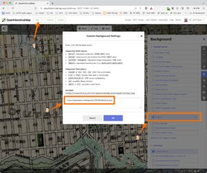
iD Editor - open the layers panel, click "Custom" and paste in a valid Tile URL template.
Map Warper
Map Warper is a set of Web tools that can be used to georeference an image and serve it up as an imagery layer. After georefencing an old map in Map Warper, you can add the imagery layer to an editor such as iD and JOSM and trace from it.
There are several interesting instance of Map Warper online.
MapWarper.net
Tim Waters (aka chippy), the author of mapwarper, operates mapwarper.net. Anyone can set up a login and start uploading maps and aerial imagery and then match coordinates up with the modern map. Once a satisfactory rectification is accomplished, a number of URLs may be found on the Export tab. The Google/OSM format URL works well as a TMS format URL in JOSM and ID. Tim's server sometimes runs out of disk space, so for long term image service, consider using the Wiki Maps server instead.
Wiki Maps
Wiki Maps uses Tim's code for https://warper.wmflabs.org/.
New York Public Library
The New York Public Library has shut down their Map Warper instance as of 2021.
Tracing a historic map
- Find a cool map to trace. You can get some ideas for great maps here.
- Check the copyright of the map you want to add
- Add the map to Commons using the map template (add {{map}} to your file in Commons and fill out the fields "author", "source" and "description" -- or simply replace "{{Information" with "{{map")
- Align the historic map using MapWarper by clicking on "Georeference the map in Wikimaps Warper" (see here for an example)
- Click on the "Rectify" tab and add *more than* 3 control points. Run the alignment and check the error, potentially fix control points until you have acceptable error (acceptable depends on your use case, if you have 100m errors, do not map buildings).
- Go to the tab "Export" and copy the tiles URL (this line "Tiles (Google/OSM scheme): http://warper.wmflabs.org/maps/tile/3274/{z}/{x}/{y}.png") or copy the line above if you want to use JOSM (right click on "for JOSM OpenStreetMap Editor")
- Load the map in JOSM (using Edit->Preferences->WMS->+WMS to add WMS layer) or into the online iD editor (Background Settings -> Custom and copy-paste the PNG layer you get from the warper). It will show up as background and allow you to trace the old map!
- Switch server URL in JOSM to http://www.openhistoricalmap.org/api/
See also
- Sanborn Map geoferencing – tracing large-scale fire insurance maps in the U.S.
External links
- timwaters/mapwarper GitHub
