OsmIntegrator/NaviAppModification
OsmIntegrator - Navigation Applications Modification - this page contains the information about modyfying navigation applications dedicated for blind to use local_ref=* tag.
Shortcuts
Stop number - it’s a number of a bus or tram stop which is present on the stop board or at least on a public transport website. It’s usually a one-digit number or combination of digit and character placed in local_ref=* e.g. “1” - for the first bus stop or “1t” - for the first tram stop Image 1.
Stop identifier - it’s a unique identifier of a bus or tram stop in a public transport system. It’s usually a few digits number placed in ref=*.
NaviApp - it’s a shortcut for navigation application, installed on a smartphone, dedicated to a blind person. Most popular navigation applications dedicated to blind persons are:
Here is a movie about how to use this kind of application.
Stop sign - it's a sign with a stop name. It's also a place where people should wait for the mode of transport and where the bus or tram will stop and open the doors on that side Image 1.
Background
ref
ref=* tag contains inforamtion about unique stop identifier. It's usually different for each stop in the city. Values like 1, 2, 3, 4 represetns 4,5% of all values in this tag and are spreaded around the world. Source: https://taginfo.openstreetmap.org/keys/ref#values
We found in our research that if this tag existed it was usually filled with 4 - 6 digits number. That numer is not comfortable to hear by blind person. It's hard to remember and is misleading orientation.
local_ref
local_ref=* tag contains information about stop number. It's unique in case of single stop only. That means, in typical situation, the stop with name 'ABCD' will have stop signs on each side of the road with local_ref=* tag '1' and '2'.
Values like 1, 2, A, 3 represents 31,7% of all values used in this tag. Source: https://taginfo.openstreetmap.org/keys/local_ref#values
local_ref=* tag is far more usefull for blind persons than ref=* because is short and easy to remember. Public transport companies are commonly using local_ref=* in General Transit Feed Specification (GTFS) files.
Algorighm
This section contains infomration about how to implement algorighm of reading local_ref=* tag in your navigation application dedicated for blind users.
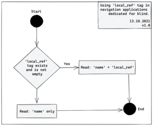
The algorighm of using local_ref=* tag is very simple [Image 1]:
- If stop object contains local_ref=* and tag isn't empty read 'name=* + local_ref=*'
- If local_ref=* doesn't exist or is empty read name=* tag only
If your application reads ref=* tag do not remove this functionality from your application! We propose the following algorithm:
- If ref=* exists and is not empty, and local_ref=* exists and is not empty read name=* + local_ref=* + ref=*
- If ref=* exists and is not empty, and local_ref=* doesn't exist or is empty read name=* + ref=*
- If ref=* doesn't exist or is empty, and local_ref=* exists and is not empty read name=* + local_ref=*
- If both ref=* and local_ref=* are empty or do not exist read name=* only.
Consider adding local_ref=* as a mandatory tag and ref=* as an option which can be turned off/on in settings.
Example objects
London City
- Westminister Station H https://www.openstreetmap.org/node/469789613
- Westminister Pier S https://www.openstreetmap.org/node/469762516
- Thomas' Hospital / County Hall D https://www.openstreetmap.org/node/469767429
- Thomas' Hospital / County Hall E https://www.openstreetmap.org/node/469767430
name=* - contains stop name ref=* - contains unique identifier local_ref=* - contains stop numer (A, B, C, D... - for stop identifiers)
Katowice City
- Katowice Rondo 1t https://www.openstreetmap.org/node/359974105
- Katowice Rondo 2t https://www.openstreetmap.org/node/1952681150
- Bogucice Kościół 1 https://www.openstreetmap.org/node/2135965713
- Bogucice Kościół 2 https://www.openstreetmap.org/node/1568958010
name=* - contains stop name ref=* - contains unique identifier local_ref=* - contains stop numer (1, 2 for bus stops and 1t, 2t for tram stops)

