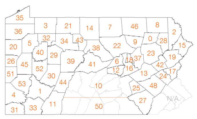
Pennsylvania/PAMAP imagery
High-resolution Yahoo aerial imagery is not available in most parts of Pennsylvania. Luckily, digital images from the PAMAP program are available for download through the Pennsylvania Spatial Data Access (PASDA). PAMAP is part of the federal program The National Map, a USGS effort to combine publicly available maps in the US.
As part of PAMAP, there a is a set of high-resolution aerial photography for the entire state. This data can be viewed on the PASDA website. For JOSM users, there is also a dedicated WMS server for these images.
Using PAMAP in JOSM
To access the imagery in a recent version of JOSM, first make sure you have the WMS plugin installed. Add a new WMS service in the WMS Preferences panel, and paste the address for the 2003–2006 cycle or the 2007–2008 cycle (incomplete coverage) into the Service URL field. Next, select the layer you wish to use and click OK.
Cycle 2003–2006
The aerial photography from 2003–2006 uses a different layer for every county. Below is a list of available layers and their WMS addresses.
The Philadelphia area (Philadelphia, Bucks, Montgomery, Delaware, and Chester counties) is not available from the PAMAP program. See The PASDA site for aerial photography for these counties.
| Layer | Year | County | Link |
|---|---|---|---|
| 0 | 2006 | Wyoming | Link |
| 1 | 2006 | Westmoreland | Link |
| 2 | 2006 | Wayne | Link |
| 3 | 2006 | Warren | Link |
| 4 | 2006 | Washington | Link |
| 5 | 2006 | Venango | Link |
| 6 | 2006 | Union | Link |
| 7 | 2006 | Tioga | Link |
| 8 | 2006 | Susquehanna | Link |
| 9 | 2006 | Sullivan | Link |
| 10 | 2003 | Southcentral PA (Cumberland, Dauphin, Franklin, Fulton, Huntigndon, Juniata, Mifflin, Perry, York) north of 40.129º N | Link |
| 11 | 2006 | Somerset | Link |
| 12 | 2005 | Snyder | Link |
| 13 | 2006 | Schuylkill | Link |
| 14 | 2006 | Potter | Link |
| 15 | 2006 | Pike | Link |
| 16 | 2006 | Northumberland | Link |
| 17 | 2006 | Northampton | Link |
| 18 | 2006 | Montour | Link |
| 19 | 2006 | Monroe | Link |
| 20 | 2006 | Mercer | Link |
| 21 | 2006 | Mckean | Link |
| 22 | 2006 | Lycoming | Link |
| 23 | 2005 | Luzerne | Link |
| 24 | 2006 | Lehigh | Link |
| 25 | 2006 | Lebanon | Link |
| 26 | 2006 | Lawrence | Link |
| 27 | 2006 | Lancaster | Link |
| 28 | 2005 | Lackawanna | Link |
| 29 | 2006 | Jefferson | Link |
| 30 | 2006 | Indiana | Link |
| 31 | 2006 | Greene | Link |
| 32 | 2006 | Forest | Link |
| 33 | 2006 | Fayette | Link |
| 34 | 2006 | Elk | Link |
| 35 | 2006 | Erie | Link |
| 36 | 2006 | Crawford | Link |
| 37 | 2006 | Columbia | Link |
| 38 | 2006 | Clinton | Link |
| 39 | 2006 | Clearfield | Link |
| 40 | 2006 | Clarion | Link |
| 41 | 2006 | Centre | Link |
| 42 | 2006 | Carbon | Link |
| 43 | 2006 | Cameron | Link |
| 44 | 2006 | Cambria | Link |
| 45 | 2006 | Butler | Link |
| 46 | 2006 | Bradford | Link |
| 47 | 2006 | Blair | Link |
| 48 | 2006 | Berks | Link |
| 49 | 2006 | Bedford | Link |
| 50 | 2003 | Southcentral PA (Adams, Cumberland, Franklin, Fulton, Huntingdon, York) south of 40.129º N | Link |
| 51 | 2006 | Beaver | Link |
| 52 | 2006 | Armstrong | Link |
| 53 | 2006 | Allegheny | Link |
| 54 | 2006 | Allentown | Link |
| 55 | 2001 | County boundaries | Link |
