Pl:Keypad-Mapper 3
| Keypad-Mapper 3 | |
|---|---|
| Autorzy: | NicRoets, Cobra, Markus59 |
| Licencja: | BSD (bezpłatny) |
| Platforma: | Android |
| Wersja: | 3.1.00 (2013-06-13) |
| Języki: | niemiecki, grecki, angielski, hiszpański, francuski, włoski, niderlandzki, polski oraz rosyjski |
| Strona internetowa: | https://www.enaikoon.com/en/about-us/openstreetmap/ |
| Instalacja: | |
| Kod źródłowy: | https://github.com/msemm/Keypad-Mapper-3 |
| Język programowania: | Java |
|
Bardzo wydajne mapowanie numerów domów. | |
Keypad-Mapper 3, aplikacja oparta na Androidzie, przeznaczona jest do szybkiego mapowania numerów domów i węzłów adresowych.
Ta aplikacja jest udoskonaloną wersją KeypadMapper2, która jest oparta na oryginalnym KeypadMapper opublikowanym przez Nic Roets in 2010.
ENAiKOON pragnie wyrazić swoje wdzięczność do Nic'a, który wspierał ich w trakcie realizacji najnowszej wersji aplikacji z jego pomysłami i cierpliwością.
|
Aplikacja skanuje aktualną pozycję GPS i GSM z wieży telefonii komórkowej i przekazuje te informacje do projektu open-source OpenCellID. |
Dostępność
Dostępne w następujących sklepach z oprogramowaniem lub za pośrednictwem bezpośredniego pobrania z Internetu:
- Keypad-Mapper 3 from Amazon application store
- Keypad-Mapper 3 from F-Droid application store
- Keypad-Mapper 3 from Google Play application store
- Keypad-Mapper 3 APK from ENAiKOON server
Szybki start
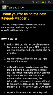
- Znajdź tutaj obszar, na którym brakuje numerów domów.
- Wydrukuj ten obszar dla łatwiejszej nawigacji i idź tam.
- Włącz GPS: możliwe jest tylko zapisywanie numerów domów i znaczników adresowych, gdy istnieje wiarygodny sygnał GPS i informacje dotyczące pozycji, w przeciwnym razie zostanie wyświetlony komunikat o błędzie.
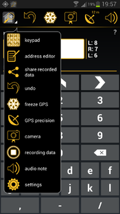
- Wybierz ikonę aplikacji w lewym górnym rogu, a następnie w opcji menu wybierz "klawiatura" lub przenieś się na ekran z klawiaturą.
- Przejdź do pozycji, na której chcesz nanieść numeru domu lub węzeł adresowy. Upewnij się, że wejście do domu jest dokładnie po prawej lub lewej stronie.
- w przeciwnym razie trudno będzie później przypisać węzeł numeru domu do odpowiedniego budynku w edytorze OSM.
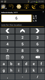
- Wpisz numer domu na klawiaturze.
- Zapisz numer domu, wybierając
 ,
,  ,
,  : współrzędne GPS zostaną zapisywane wraz z węzłem adresowej, który jest w danej chwili aktualny kiedy użytkownik naciska na
  ,
,  ,
, 
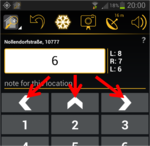
 oznacza, że numer domu jest po lewej stronie w stosunku do kierunku przemieszczania się.
 oznacza, że numer domu jest po prawej stronie w stosunku do kierunku przemieszczania się.
 oznacza, że numer domu jest przed nami w stosunku do kierunku przemieszczania się, np. na T- skrzyżowaniu.
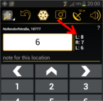
- W lewym górnym rogu znajduje się licznik liczby numerów domów, które zostały odwzorowane w bieżącej sesji mapowania.
- Powtórz kroki 5) , 6) i 7) dla każdego numeru domu, aż wszystkie numery domów zostaną zarejestrowane.
- Po zakończeniu mapowania numerów domów, wybierz ikonę obrazującą mały domek, w lewym górnym rogu, a następnie wybierz "Ustawienia".
- W ustawieniach ekranu można znaleźć opcję "udostępnij zapisane dane", która pozwala na wysyłanie zapisanych danych jako załącznik e-mail do komputera używanego do edycji OSM (np. JOSM)
- Otwórz wiadomość e-mail i zapisz załączone pliki w komputerze.
- Otwórz edytor OSM, a następnie otwórz plik
gpsi plikosmo tej samej nazwie, a także odpowiednie zdjęcie. Załaduj dane OSM dla określonego obszaru. Powinieneś zobaczysz wszystkie zapisane numery domów, oraz trasę pobraną w trakcie nagrywania danych, jak również ikony dla każdego wykonanego zdjęcia na górze istniejących danych OSM. - Przypisz każdy numer domu do odpowiedniego budynku; spójrz na zdjęcia i przesłuchaj audio notatki, aby zapamiętać wszystkie dostępne informacje w celu optymalizacji danych.
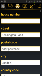
- Przypisz do każdego numeru domu odpowiednią nazwę ulicy, kod pocztowy, nazwę miasta i nazwę kraju (addr:street, addr:postcode, addr:city, addr:country)
- Załaduj zoptymalizowane i wypełnione dane OSM.
- Usuń zapisane dane na telefonie/tablecie używając opcji z menu ustawień "usunąć wszystkie zgromadzone dane" na ekranie ustawień.
Zazwyczaj znajdziemy nowo przesłane numery domów na mapie OSM na najwyższych poziomach powiększenia kilka minut po pobraniu ich i po odświeżeniu okna przeglądarki z mapą OSM.
Zrzuty ekranowe
OpenCellID
OpenCellID jest open-source komplementarnym projektem do OSM.
Celem tego projektu jest zebranie współrzędnych GPS pozycji stacji bazowych GSM. Dane zebrane przez autorów tego projektu można pobrać z OpenCellID zgodnie z warunkami licencji "Open Database".
Jednym z głównych powodów, dla zbierania OpenCellID danych jest to, że będzie możliwe późniejsze ich wykorzystane do lokalizowania urządzeń w miejscach, gdzie sygnał GPS nie jest dostępne.
Keypad-Mapper 3 jest doskonałą aplikacją do zbierania danych OpenCellID jednocześnie zbierając numery domów, ponieważ użytkownicy Keypad-Mapper 3 systematycznie przemierzają różne ulice, co gwarantuje optymalne dane OpenCellID. Stacje bazowe wzdłuż głównych dróg mogą być już w bazie danych, ale stacje bazowe przy głównych ulicach są rzadkością. To sprawia, że Keypad-Mapper jest cennym źródłem danych CellID. Ta funkcja nie może być wyłączona.
Polecamy używanie KeypadMapper2, jeśli nie chcemy wnieść kontrybucji do OpenCellID.
Odczytywanie danych OpenCellID z modemu GSM wymaga zgody 'na czytanie stanu telefonu i jego tożsamości'. Aplikacja nie wykorzystuje żadnych innych informacji o stanie telefonu i tożsamości z wyjątkiem MCC, MNC, LAC, CellID i moc-sygnału. Realizacja tej funkcji zapewnia, że dane są zbierane anonimowo (patrz talk:Keypad-Mapper 3), zapewniając pełną zgodność z bardzo restrykcyjnym prawem do prywatności w Niemczech.
OpenCellID dane są przesyłane przez Internet do serwera OpenCellID natychmiast po ich zebraniu. Jeśli tylko opcja Wi-Fi jest włączona w menu ustawień, dane są przechowywane w telefonie do momentu dostępności połączenia Wi-Fi.
Porady i wskazówki w celu skutecznego odwzorowania numerów domów
Ogólne
- numeracja domów w Wikipedii (en)
- addresses (en) w OSM
- znaczniki dla numerów domów i adresów w OSM
- Karlsruhe Schema (en)
- domy z wieloma adresami (en)
- World bank: Street Addressing and the Management of Cities
- Wskazówki dla mapowania wejść
- lista z punktacją osób importujących numery domów
- statystyka dla Key:addr
- dyskusja na temat najlepszego możliwego tagowania adresu
JOSM
- Przytrzymując klawisz SHIFT podczas dodawania węzłów pozwala na szybkie dodawanie wiele węzłów bez konieczności opuszczenia każdej drogi po dodaniu pierwszego węzła. To wiąże się z użyciem lewej ręki.
- Przytrzymanie klawisza CTRL podczas przeciągania numeru domu i upuszczenie go w pobliżu innego węzła spowoduje połączenie węzłów. To wiąże się z użyciem lewej ręki.
- video: Edycja adresów w JOSM
- Czasami mamy zły lub nie mamy sygnału GPS podczas tagowania. Może to spowodować zlepianie się numeracji domów i przypisanie adresu do domu jest skomplikowane. Jeśli pamiętamy sekwencję oznaczania wątpliwego domu, wyświetlanie sekwencji tagowania numeracji może pomóc. Procedura jest wyjaśniona tutaj.
- Wtyczki
- AddrInterpolation – Wtyczka JOSM do tworzenia interpolowanych adresów i sposoby przeniesienia interpolacji adresów wzdłuż drogi do indywidualnych adresów domów.
- FixAddresses – Wtyczka JOSM zapewniająca wygodny sposób na znalezienie niepełnych lub nieprawidłowych adresów.
- JOSM i numeracja domów (en)
- HouseNumberTaggingTool – Narzędzie do łatwego dodawania informacji o adresie do węzła lub drogi; można znaleźć w sekcji menu "Edycja"
Potlatch 2
Potlatch2 nie może załadować plików osm (o tak, to możliwe!). Dlatego Potlatch nie nadaje się do przetwarzania Kepad-Mapper-3 danych.
- video: jak dodać adres w Potlatch
iD
jeszcze nie testowane
Narzędzia zapewniające jakość adresowania
walidator numeracji domów
niekompletne adresy
addr:postcode areas Niestety, serwer jest niedostępny ze względu na problemy techniczne; wrzesień 2013, wambacher
Narzędzia do znalezienia regionów z brakującymi adresami
Kod źródłowy
Kod źródłowy jest dostępny w github
Zmiany
Nowa wersja 3.1
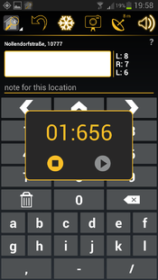
zapis notatki głosowej:
| Recording an audio note is less conspicuous to others than taking a photo, therefore some mappers prefer to record voice memos instead of taking GPS photos in order to avoid calling the attention of passerby. The audio note feature works similarly to the photo feature: it allows you to record a voice memo and save it along with a GPS coordinate. Unlike .jpg files, the GPS coordinates for audio notes are stored in the .gpx file, therefore the .gpx file must be loaded in JOSM before loading the .wav file.
The audio note entry in the .gpx file has the following content:
|
the RECORD button has been restored:
improved history:
the survey date is saved with each address tag:
See: Key:survey:date
Example:
- <node id="-1" visible="true" lat="52.497442495127025" lon="13.350499497003666">
- <tag k="survey:date" v="2013-06-01"/>
- <tag k="addr:housenumber" v="15"/>
- </node>
optimized screen layout for larger screens:
Some mappers are using 7" to 10" tablets for mapping. The relatively new Google Nexus 7 seems to be especially wide spread amongst mappers. This can be attributed to the fact that these devices have a longer battery life, allowing mappers to go on extended mapping tours without having to change the battery.
The new Keypad-Mapper version 3.1 provides a completely new user interface, optimised for tablet users in both landscape and portrait modes:
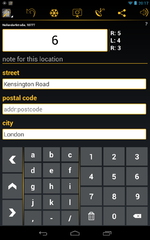
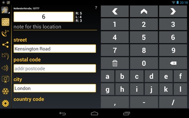
This UI is automatically activated on all devices with a minimum screen size of 7". Samsung Galaxy Note 1 and 2 are NOT using the tablet layout. Despite the fact that they are categorised as tablets the screen area available on these devices is not big enough for a proper tablet layout.
The tablet layout differentiates from the phone layout as follows:
- different sorting order of the icons in the menu bar:
the most important icons are as close to the position of the thumb as possible - more icons are shown in the menu bare compared to the phone layout
- the keypad screen and the address editor screen are both visible at the same time:
this gives a better overview of the currently configured / mapped data - the house number entry field is missing in the address editor screen
- in portrait mode, the keypad layout of the landscape mode for phone UI is used; this makes two-hand data entry possible
L/F/R and CLR on keypad screen replaced by icons:
L/F/R on keypad screen has been replaced by ![]() ,
, ![]() ,
, ![]() , 'CLR' has been replaced by
, 'CLR' has been replaced by ![]()
improved usability:
- a long tap on the house number entry field in the keypad screen opens a full keyboard for entering an unusual house number
- various readability improvements (e.g. bigger characters, better contrast, etc.) especially for mapping under direct sunlight
- improved response time of the app in case many house numbers were mapped
- in the address editor screen the house name entry field was moved to the bottom of the page
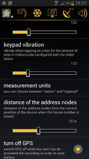
additional settings options:
- turn off GPS:
allows you to optionally continue with the .gpx route recording even when the Keypad-Mapper 3 app is on in the background and/or while the screen is off - vibration on save:
defines the duration of the vibration in milliseconds when saving an address node (when tapping on ,
,  ,
,  )
) - keypad vibration:
defines the duration of the vibration in milliseconds when tapping on any key except ,
,  ,
,  on the keypad screen
 - use compass:
defines a speed up to which the compass information is used instead of the GPS heading information for calculating the direction - .WAV file path:
defines the .wav file path on your computer which will be used to save the recorded audio notes; this information is required by JOSM for proper loading of the .wav files
The sequence of the settings options on the settings screen has been optimized.
new in version 3.0
menu icon 'address editor':
| Tapping on this icon launches the address editor screen |
menu icon 'keypad screen':
| Tapping on this icon launches the screen for entering house numbers |
freeze GPS position:
There are other cases, like the situation shown in the pictures below, where the house number is hidden, making it necessary for you to pass the entrance and then look back for reading the house number:
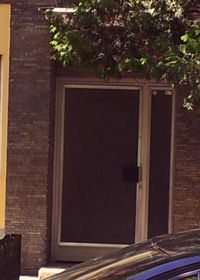
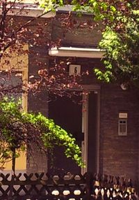
With the FREEZE option you can freeze the actual GPS position of the entrance (indicated by the highlighted freeze icon).
This allows you to go to the place where the house number is visible, enter the house number, and save it with the previously saved GPS position of the entrance.
After saving the house number by tapping on ![]() ,
, ![]() ,
, ![]() , the freeze mode is cancelled automatically and the freeze icon is no longer highlighted.
, the freeze mode is cancelled automatically and the freeze icon is no longer highlighted.
Another use case of the freeze GPS option is taking a photo with the GPS coordinates of the subject in the photo:
in this case, you can go to the place where the subject of the photo is located, use the freeze GPS option, and then relocate to take the picture of the subject.
This ensures that the GPS coordinates stored inside the JPEG file points to the position of the place and not to the position of the photographer.
take photos:
| The day-to-day experience of mapping house numbers has proven that GPS photos are useful for remembering complicated situations or additional information that has nothing to do with house numbers but is interesting enough to being mapped. In many cases, such photos save the mapper from entering additional text (e.g. for remembering a complete address printed on a menu, hints for special signs, etc.). The photo is taken with GPS information stored in the Exif meta data of the JPEG file. The photo can be uploaded along with the .gpx and .osm files to JOSM or to any other OSM editor and will be shown on the map where it was taken. |
optional text entry:
A separate field has been implemented for entering additional text, assigned to TAG key 'name'. While entering such additional text, a full keyboard is shown on top of the keypad with all required characters.
This is especially helpful when saving notes for future reference when optimising the data later in an OSM editor or if a house number must be mapped with characters different from the ones on the keypad.
The note is stored in the .osm file assigned to a TAG with type 'name'.
Example:
- <node id="-1" visible="true" lat="52.49750275564635" lon="13.35025888569893">
- <tag k="name" v="this is your additional text"/>
- <tag k="addr:housenumber" v="51"/>
- </node>
This information can be deleted with the OSM editor after using it or it can be assigned to the correct TAG type.
motivation:
The number shown in the circle of the app icon indicates the number of house numbers mapped that day.
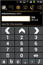
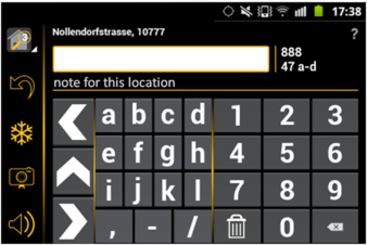
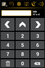
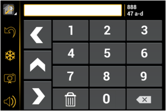
optimisation of the keypad screen for small devices:
Users of devices with small screens can hide several elements of the keypad screen:
- question mark for launching the help screen
- display of street name and postcode
- entry field for additional text
In addition fewer characters are shown on smaller screens.
In case that you are using a small screen, all characters are made available if you turn the device to landscape orientation:
history:
The last two or three stored house numbers are continuously shown on the right side of the house number entry field.
The amount of shown house numbers depends on the size of the screen.
undo:
| This option removes the most recently added house number from the .osm file. It is not possible to undo more than one previously recorded house number. |
display of current street name and postal code:
Current street name and postal code are shown based on NOMINATIM data (only visible if the device is online). This allows seeing if the data already stored in the OSM database is correct and complete and whether there are typos in the existing data.
connect to the internet via Wi-Fi only:
This option is especially helpful if your current GSM data plan is expensive or if the amount of free data is limited.
measurement units:
Both metric and imperial measurement units in metres and feet are supported for entering the distance between the current device position and the position of the address nodes. This allows the use of the software in countries with imperial measuring units.
keep screen on:
This option keeps the screen of the device on while mapping.
swipe from screen to screen:
The user has the choice to either tap on a menu item to open another screen or to swipe horizontally over the screen with one finger to get to another screen.
share recorded data:
delete all recorded data:
This option is normally used to free some space on the device as soon as the collected data has been successfully sent to the PC running the OSM editor.
detailed help text:
A detailed help text in all nine supported languages is available for a quick understanding of the app's main features.
nine languages:
- Dutch
- English
- French
- German
- Greek
- Italian
- Polish
- Russian
- Spanish
Special thanks to Stefano for the Italian translation as well as for the promotion of Keypad-Mapper 3 on talk-it
Additional thanks to Adam for the Polish translation and to Harry for the Dutch translation.
If you would like to translate the Keypad-Mapper 3 into another language, please contact User:Markus59.
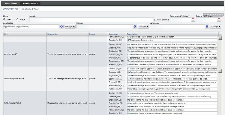
resource editor integration:
All text resources and graphics resources used by the app are maintained in the ENAiKOON resource editor.
This is a server-based web application.
Advantage: an additional language or any changes of some existing resources are immediately available for all users of the app without the need of updating the entire app.
crash reports:
In case the app crashes, there is an option to send a crash report with important information (e.g. a stack trace) to the Keypad-Mapper 3 developers.
This allows them to find and fix the bug in order to ensure the highest possible quality. No private data, including passwords, is sent to the developers.
only one version for all Android versions:
All Android versions from 2.1 to 4.x are supported.
app icon:
'GPS precision' screen:
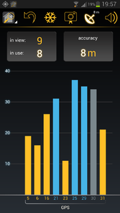
The screen 'GPS precision' gives information about the current GPS reception.
| The GPS precision icon in the menu bar shows the GPS precision in metres or feet depending on the measurement unit settings. |
| If the compass of the device is used for calculating the direction, then a compass needle in the GPS icon is shown. |
| If the GPS precision icon in the menu bar shows no number, then there might be GPS reception, but quality is not good enough for the Keypad-Mapper. |
other great apps for mapping house numbers:
The main idea behind Keypad-Mapper 3 is to map house numbers, and eventually address nodes, as efficiently as possible for a seamless editing of data later at home with JOSM or any other OSM editor.
Many mappers feel that adding tags other than the house numbers while mapping is a waste of time and that it can be done more effectively and conveniently later at home.
Other OSM mappers prefer completing the data immediately while collecting it, including a precise position of the node on the map.
OSM mappers with this preference might prefer OsmPad.
OSM mappers that prefer not to specialize in house number mapping but would rather map multiple geo data at a given position may prefer the OSMtracker app.
Potrzeby
Zobacz talk:Keypad-Mapper 3#wish list
at SOTM2013
During the SOTM 2013 OpenStreetMapconference in Birmingham Markus presented version 3.1 of the Keypad-Mapper 3. PDF slides of the presentation are available for download. The video is available at http://lanyrd.com/2013/sotm/scpkgq/
Sponsorowanie
Rozwój Keypad-Mapper 3 jest sponsorowany przez ENAiKOON GmbH.
