Proposal:IMBA Trail Difficulty Rating
| IMBA Trail Difficulty Rating System | |
|---|---|
| Proposal status: | Abandoned (inactive) |
| Proposed by: | * |
| Tagging: | mtb:scale:imba=0 to 4 |
| Applies to: | linear |
| Definition: | Relative technical difficulty of built recreation trails (e.g. North Shore) |
| Statistics: |
|
| Rendered as: | Same as footways, with suitable indications on hiking maps |
Replaced by
Proposed features/mtb:scale replace it, the rest is kept for archives Sletuffe 23:20, 26 November 2008 (UTC)
Rationale
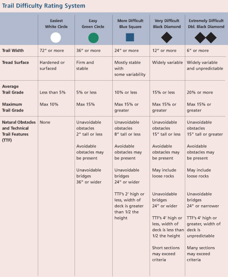
The IMBA Trail Difficulty Rating System is a method used to categorize the relative technical difficulty of recreation trails. The system best applies to mountain bikers, but is also applicable to other visitors such as hikers and equestrians:
- Help trail users make informed decisions
- Encourage visitors to use trails that match their skill level
- Manage risk and minimize injuries
- Improve the outdoor experience for a wide variety of visitors
It is similar to the marking system for skiing slopes in Proposed features/Piste Maps, and can be used in conjunction with Key:sac scale and Key:trail visibility to provide a classification scheme for hiking trails suitable for singletrack and downhill biking.
This can be used to create hiking maps that are especially useful for planning mountain biking outings.
Details
Graphics reused with permission from IMBA.
In Norway there have been a project for developing a similar system for marking of MTB and hiking trails: Innovativ fjellturisme (in Norwegian only—will review/translate this), an important resource for this project was the "Whistler Trail Standards", as well as the IMBA rating.
