Proposal:Military area
| Military area | |
|---|---|
| Proposal status: | Abandoned (inactive) |
| Proposed by: | Gilles_tagada |
| Tagging: | boundary=military |
| Applies to: | way,area |
| Definition: | Boundary of areas used by military |
| Statistics: |
|
| Draft started: | |
| Proposed on: | 12-Oct-2009 |
| RFC start: | 13-Oct-2009 |
| Vote start: | * |
| Vote end: | * |
Definition
Used to mark the external limit of the military area, including forests, beaches... Consecuently, can be used with "military=*", "landuse=*", "natural=*", "amenity=*"... (not limitating list).
When a military base is composed of different areas (a forest, a training ground and a building for example), the tag "boundary=military" is only put to the external limits (generally fences), not between the "military" forest and the training ground.
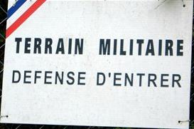
The tag is used to mark the limit of the area which is military owned. Access is forbiden for the public. You usually find fences or walls, but on larger area, only signs are visible.
Example photo
 Sign marking french military areas.
Rationale
For a lot of land types inside a military base (forest, lakes, rivers...), it's impossible to use 2 tags : "landuse=military" and "landuse=forest" (for example). Military bases can also include sport facilities, parking lots, schools...
Possible icons
The same as "boundary=national_park", but in red. Appears on zoom 7 and above. If a "name=*" is set, appears for zoom 8 and above.
Further Discussion
To the talk page please.