Proposal:Scenic
| scenic quality of tracks/paths for tour planning | |
|---|---|
| Proposal status: | Canceled (inactive) |
| Proposed by: | GPSfriend |
| Tagging: | scenic=scenicgrade1 (best) to scenicgrade4 (worst) |
| Applies to: | |
| Definition: | tag classify the beauty of tracks/paths |
| Statistics: |
|
| Draft started: | 2018-05-29 |
| RFC start: | 2018-05-31 |
Proposal
Add a tag "scenic=scenicgrade<n>" to highways, tracks and paths to classify the beauty of the way.
Rationale
There are two major use cases I have in mind
- routing from point A to B not only by shortest distance or shortest travel times, but allowing e.g. a 10% longer route if it runs through nature instead of using a heavily used street.
- asking my mobile for "any beautiful (relaxing) 20km round trip" by bike or by foot (or by car?) starting from my current location"
Today any navigation tool tends to give you routes that use fast major streets and you mostly have to imagine from the map that "nicer" parallel ways exist. Especially for family tours with recreational focus or with smaller children these more beautiful and more silent alternatives would be great. Currently the data base can hardly supports such algorithms. If tracks and paths would be classified for example in 4 grades the quality could be optimised automatically. In addition the routes could explicitly include "wow-paths" in tours, depending on later algorithms.
In addition this would offer the chance to generate "beautiful round-trips" from any location. You could set "means of transportation" (Foot, bicycle, car?), length, desired track surface (e.g.minimum trackgrade3)and have an algorithm generate a multitude of nice tours. This tag "scenic" would allow to sort the trips for example by average scenic-ness and you could choose the nicest.
I think this feature could be a USP for openstreetmap-based navigation for quite some time and it could make many families happy.
Tagging
The tag could be used for ways in (possibly) 4 grades:
- scenic = scenicgrade4 Use for ugly and stressful streets you would only choose for biking or hiking if you want to be fast or if there is no alternative
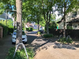
- scenic = scenicgrade3 Use for nicer and more silent streets with less traffic and more trees, more e.g. separate cycleways in an alley of trees, suburbian or living-streets.
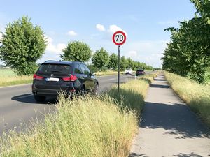
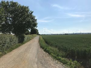
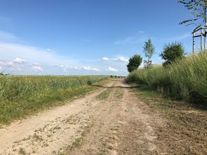
- scenic = scenicgrade2 Use for ways that are surrounded by nature, like fields, forest and few or no houses and cars (!). Enjoy the countryside. Note: on heavily used highways without separated cycleways in the countryside I propose to use scenicgrade4, because you could not focus on nature but on survival on the street. For the same highway in the countryside with separated cycleways your attention would still be drawn to the heavy traffic, so scenicgrade 3 should be applicable.
- scenic = scenicgrade1 Use for the very few wow-effects, when you think "now this is a really wonderful way". This should be used less than 10% of scenicgrade2 in order to differentiate the top highlights.
I currently prefer only 4 levels to keep them easier to distinguish.
Applies to
The tag "scenic" would be applied to any kind of way, e.g. tracks, paths, residential highways etc. I propose not to use it on nodes as there are already tags for different spots like viewpoints and a routing algorithm would use the length of the segment for evaluation of the total quality of the route.
Examples
I took some pictures today to give an idea of the logic:
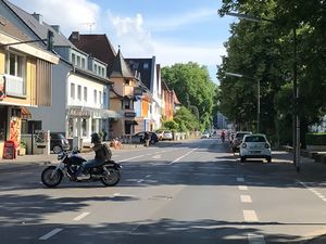
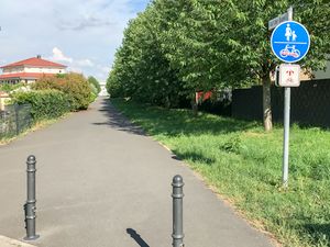
| Scenicgrades | Example-Images | Comment |
|---|---|---|
| scenicgrade4 | Urban secondary street, high traffic volume, no separated cycleway | |
| scenicgrade3 | ||
| scenicgrade2 | Way in countryside | |
| scenicgrade1 | Anybody should remember a REALLY nice way |
Rendering
Rendering is to be discussed. Colors could be used for tagged ways, although it might suffice to mark only scenicgrade1 or 1&2, e.g. by a green line along the way just like in some paper maps.
Features/Pages affected
The page Key:scenic would be changed and if people like using this tag it might go into the Key:highway page or Map-features. (Would need advice here as this is my first proposal)
Up to now the key scenic is rarely used, i.e. some 5000 ways which are classified as yes/no. Both systems could coexist.
External discussions
I'm not aware of any prior discussions on this idea.
Comments
Please comment on the discussion page.
