Proposal:Vessel
| Vessel | |
|---|---|
| Proposal status: | Abandoned (inactive) |
| Proposed by: | VileGecko |
| Tagging: | vessel=* |
| Applies to: | |
| Definition: | Tagging ships with permanent locations in a uniform manner |
| Statistics: |
|
| Draft started: | 2020-08-23 |
Rationale
While ships are in fact moving vehicles some of them due to their circumstances, history or function are moored or anchored permanently or semipermanently in the same place often making them an important landmark or even a point of interest. This includes houseboats, museums, restaraunts, shipwrecks, lightships, constructed, arrested or scrapped ships etc. As of now these ships if they are mapped at all are considered to be buildings (even though Wiki advises against such practice) with considerable amount of tagging ambiguity unless this is a museum, wreck or a houseboat. At the same time there is a tagging scheme in place under key:seamark:hulk:category but it is only used for marine navigation and does neither contribute to regular OSM mapping nor benefits from it. It is understood that implementing the key:vessel may create temporary redundance in maritime tagging but it was devised with the IENC encoding and the existing key:seamark kept in mind to make merging and cleanup as seamless as possible. While lumping ships in the same category as buildings may be fine for the purposes of the Carto style as well as other map layers intended only for terrestrial navigation, water navigation and topographic styles on the other hand may significantly benefit from having an ability to render ships separately or omit them where they might not be considered permanent objects enough. Introduction of the key:vessel should place all existing ship tagging in one scheme and add new ways of tagging ships.
This is a second take on an attempt to implement a tagging scheme for ships, the old one can be seen here. The first intention was to use the ship=* key but now it is already occupied by the access family of tags with more than 13,000 uses. The key vessel=* unfortunately does not fit well with the existing ship:type key name (which on the other hand has only about 460 uses and is possible to be replaced with the key vessel:type at a later time). Another downside is that ship=wreck would have been more intuitive than vessel=wreck. Nevertheless all new refining keys created in association with the vessel=* key are advised to have a vessel:* prefix.
Proposal
It is proposed to use the new vessel=* key for tagging permanently moored, anchored or grounded ships.
The key implies only the current role of the ship in the environment and not its original purpose - for this the key ship:type=* should be used instead.
This key does not apply to active ships - the ship must be evidently out of service or movement.
This key does not apply to ships transfered ashore and converted into memorials to such an extent that they are indiscernible from buildings. However if a functional boat is stored ashore and might be expected to be used sometime in the future she should be marked as a ship.
This proposal also includes a section for wreck tagging to make it uniform with other values of the vessel=* key as well as to make it usable in maritime layers.
How to map
Ships should be mapped with a polygon similarly to buildings. Shipwrecks are mapped the way they are seen from the above including the submerged part to the extent where it is still discernible on aerial imagery or the boundaries of the wreck are known otherwise. Submerged shipwrecks are mapped with a node unless the silhouette can be seen on aerial imagery or is otherwise known.
When a decomissioned and repurposed ship is towed to a new permanent mooring place nearby so far as practicable the mapped object should be also transfered to a new location instead of deleting the old and creating a new one. If a mapped ship changes its status (e.g. a restaurant is repurposed into a musem or sinks as a result of an accident) the old object should be retagged instead of creating a new one. When a ship is removed, destroyed or becomes active again the object should be deleted.
Tagging
Ship Tagging
| Picture | Key/Value | Description |
|---|---|---|
 |
vessel=yes | Basic value. Used for ships that are still in comission but due to legal, financial or operational (including dock repairs) reasons are moored or stored ashore at the same place for extended periods of time but are expected to move out sometime in the future. Ships in this category should only be mapped when they stay in the same place for more than 6 months and may serve as a landmark. |
 |
vessel=restaurant | Used for ships permanently moored in the same place and used as a restaurant, casino, etc. May be subject to indoor mapping.
Corresponds to IENC category CATHLK=1 (floating restaurant) and seamark:hulk:category=floating_restaurant possibly replacing the latter tag in the future if agreed upon. |
 |
vessel=museum | A permanently moored floating structure, such as an old ship, used as a museum. May be subject to indoor mapping.
Corresponds to IENC category CATHLK=3 (museum) and seamark:hulk:category=museum possibly replacing the latter tag in the future if agreed upon. |
 |
vessel=wharfboat | A permanently moored floating structure resembling a building used for mooring other ships, transfer of people and goods and accomodating workers and services. Most often used as river passenger terminals but may also be used for military, law enforcement, industrial, scientific or other purposes. Unlike floating piers these structures have several decks and are possibly subject to indoor mapping. |
 |
vessel=industrial | Large ships designed as floating plants for extracting and processing substances, transfering huge quantities of goods, power generation etc. While many of them are self-propelled they often spend years berthed or anchored in one place. Unlike ships with the value vessel=yes industrial ships can be extensively tagged with the same tags as terrestrial industrial sites or offshore platforms. |
 |
vessel=houseboat | A houseboat is a permanently moored boat or a floating structure used for accomodation of people. This includes not only homes but floating hotels as well. May be subject to indoor mapping. Directly replaces the building=houseboat tag.
Corresponds to IENC category CATHLK=4 (accomodation) and seamark:hulk:category=accomodation possibly replacing this tag in the future as well. |
 |
vessel=lightship | A distinctively marked vessel anchored or moored at a charted point, to serve as an aid to navigation. By night, it displays a characteristic light(s) and is usually equipped with other devices, such as fog signal, submarine sound signal, and radio-beacon, to assist navigation. As many of those have been decomissioned and repurposed only use vessel=lightship when she is still used as an aid to navigation. For decomissioned lightships use vessel=restaurant or vessel=museum + ship:type=lightship instead.
Corresponds to seamark:type=light_vessel and is used in conjunction with it as one key stands for the ship's outline while the other for the light she displays. |
 |
vessel=construction | A ship being constructed for extended period of time especialy where the construction has come to a halt. Consider mapping such ships only if they are not expected to leave the dock anytime soon. |
 |
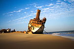
vessel=wreck | A wreck is a nautical craft that has unintentionally been sunk, destroyed or grounded and then abandoned. A wreck can persist for many centuries and can be a hazard to navigation, anchoring or submarine operations as well as a point of interest for divers. As not all wrecks have historic value therefore it is proposed to make vessel=wreck the general tag for those and historic=wreck to only further mark wrecks of historic importance.
Several poposed edits to the wreck taging system are provided below. This can facilitate cleanup and harmonization with Seamarks/Wrecks. |
 |
vessel=scrap | A ship which has been decomissioned and deliberately stranded aground. While in the areas of ship graveyards those ships are often quickly dismantled, in other places hulks may lay untouched for many years awaiting their doom. Unlike wrecks scrapped ships are usually located out of the way of traffic and do not pose a threat to navigation. |
For the purposes of nautical map layers it is proposed to use tag combination of vessel=yes + historic=ship in place of seamark:hulk:category=historic, which corresponds to IENC category CATHLK=2 (historic ship) instead of introdicing the redundant vessel=historic value.
CATHLK=5 (floating breakwater) is covered by a tag combination of man_made=breakwater + floating=yes without any need to introduce a redundant and ambiguous vessel=floating_breakwater value.
Accompanying tags
| Key | Value | Description | Usage |
|---|---|---|---|
| ship:type | <type> | Type of ship with regards to her latest operational function and architecture | Recommended |
| name | <name> | Name of the ship as it is officially known in her flag state | Recommended |
| int_name | <name> | Name of the ship in Latin characters as it is officially used | When name is not in Latin characters |
| old_name | <name> | Previous name of the vessel | Optional |
| ref | <combination> | Military code of a warship or inventory number of a floating structure. For IMO and official numbers other keys should be used | If applicable |
| int_ref | <number> | Ship's IMO number | Recommended |
| nat_ref | <number> | Ship's official number | Recommended |
| seamark:radio_station:callsign | <combination> | Ship's callsign | Optional |
| seamark:radio_station:mmsi | <number> | Ship's MMSI | Optional |
| length | <length> | Length overall in metres | Optional |
| width | <width> | Breadth moulded in metres | Optional |
| vessel:grt | <number> | Gross register tonnage; do not include any value after the number | Optional |
| vessel:dwt | <number> | Deadweight in metric tonnes | Optional |
| material | <material> | Ship's hull material - usually steel, wood or plastic, sometimes concrete | Optional |
| colour | <colour> | Ship's hull colour | Optional |
| access | <access> | If a ship or a structure is readily accessible to general public | Optional |
| wikipedia | <link> | Link to a Wikipedia article on a subject | Optional |
| wikidata | <link> | Link to a Wikidata entry on a subject | Optional |
Other additional keys are not as important for the purposes of 2D mapping
Wreck tagging
For the purposes of uniformity and interusability the following tags should be introduced replacing or cancelling others:
| New key | Key to be replaced | Times used | Definition |
|---|---|---|---|
| depth | wreck:depth; wreck:clearance seamark:light:depth - upon agreement with maritime layer providers |
164 + 70 | The least depth of the wreck compared to the chart datum |
| height | wreck:depth; wreck:clearance | 164 + 70 | Vertical distance between the seabed and the highest mast or superstructure or the charted depth |
| vessel:grt | wreck:gross_tonnage | 32 | Gross register tonnage; do not include any value after the number |
| length | wreck:length | 98 | |
| width | wreck:width | 80 | |
| cargo | wreck:cargo | 27 | Cargo on board with which the ship sank; not to be used with other vessel=* values - ship:type should be used insted |
For correct rendering of the wreck the tag seamark:wreck:category should also be set. Tagging of the seamark:wreck:water_level is also recommended.
seamark:type=wreck is redundant as it is but its merging with vessel=wreck needs further discussion.
Rendering
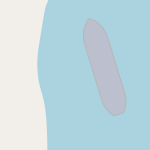
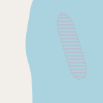
For the standard Carto style it is proposed to fill the shape of a vessel with the colour #bcc0ce and to mark the outline with #b6b6b7. Ships which are out of order should have their outline dashed. Shapes of wrecks which are not constantly visible should be hatched. Wrecks which are constantly submerged should only be shown as dashed outlines. New Carto-style icon for marking shipwreck nodes and areas is introduced.
| Picture | Node | Area | Key/Value |
|---|---|---|---|
 |
n/a |  |
For intact ships; basic value |
 |
n/a |  |
vessel=construction |
 |
n/a |  |
vessel=scrap |
 |
 |
vessel=wreck + seamark:wreck:category=hull_visible | |
 |
 |
vessel=wreck + seamark:wreck:category=hull_showing vessel=wreck + seamark:wreck:category=mast_showing | |
 |
 |
vessel=wreck + seamark:wreck:category=dangerous vessel=wreck + seamark:wreck:category=non-dangerous | |
 |
n/a | vessel=wreck + seamark:wreck:category=scattered |


