Proposal:Extended playground equipment/Guidelines for detailed playground mapping
Playgrounds (leisure=playground) and especially playground devices (playground=*) can be mapped in detail to evaluate the equipment and quality of a playground. This page gives guidance on mapping playgrounds in detail.
Playground device mapping
Detailed playground mapping is based on capturing the type and location of individual playground equipment by tagging them with playground=* (e.g. playground=swing at the location of a swing). The wiki page contains an extensive list of playground equipment.
Node, way or area?
As usual with OSM, this is often a question of what makes sense in the first place and also whether features are amenable to being mapped in a certain way. In experiments over the last few months a few common themes emerged:
1. Mapping equipment as nodes for quick mapping what is available remains a good option to quickly add equipment where not yet present. Data consumers such as Babykarte don't require exact locations or shapes.
2. For adding further detail, some features are naturally area-shaped, such as sandpits, structures and lend themselves to being represented by an area. Especially for structures this also enables to add devices attached to that structure in a natural manner.
3. Especially from structures a number of linear features may branch off, such as bridges or slides. Those typically have one end node on the structure outline. A number of point-like features like ladders, sand play equipment like chutes, etc. also are usually tagged as nodes on the structure outline. Other linear features like zip lines, horizontal bars or anything else that's traversed in a particular direction, like balance devices, monkey bars, etc. can often also be mapped as ways.
ToDo
Additional tags
Many devices can be tagged with further detailed information, e.g. on their size, material, accessibility or user group. This allows detailed evaluation options such as searching for playground equipment for children of a certain age or with disabilities. Besides, wouldn't it be interesting to be able to find the highest, longest and steepest slide in the city with OSM?
For this, it is worth adding some extra tags that are already documented.
Physical properties
- material=* of the equipment (e.g. wood, metal or plastic on constructions or chain and rope on climbing devices),
- height=* of equipment such as slides or climbing frames,
- incline=* of slides or climbing slopes,
- capacity=* on swings, seesaws etc. to indicate the number of people who can use a device at the same time,
- handrail=* on equipment that provides something to hold on to by hand,
- as well as other tags that can be useful on individual devices (e.g. covered=* on tunnel slides, step_count=* on stairs and ladders).
Moreover, some mappers use of the following tags for specific statements:
- seating=yes/no or standing=yes/no to indicate whether a device can be used standing or sitting (see examples).
Accessibility
- Suggestions for tagging information on accessibility are already documented in the wiki.
Age groups
ToDo
- baby=* vs. provided_for:*=*
Mapping of structures and bridges
ToDo
- Distinction between different bridges (fixed vs. swing/rope bridges, see already in the wiki).
- Usage of platform, tagging of levels etc.
- Example sketch of a detailed mapped structure with platforms, bridges, stairs, slides etc.
Further tagging ideas
- More/better documentation about how to map certain things as non-nodes. Nodes are probably always centered on the object. For way-like objects (balance beam, slide, zipway, etc.) ways are fairly self-evident. However, I've been mapping swings typically as ways that follow the bar on which the swings are mounted, which then is perpendicular to the swinging direction. Perhaps that's okay, but perhaps we can give more guidance for specific examples. A simple sentence like the common »how to map« instruction is probably enough. Ygramul (talk) 06:14, 18 August 2022 (UTC)
- Detailed mapping of structures can be somewhat complicated, although one could probably take a few pointers from mapping buildings (both indoor and outdoor). This could include both things like parts, roofs, levels, height/min_height, equipment inside the structure (like ladders leading upwards, or table and benches in the lowest floor, etc.). Ygramul (talk) 21:48, 18 August 2022 (UTC)
- Structures may not be as regular as normal buildings and levels may not be evenly distributed. Adding things like platforms inside structures to also keep the height may work. However, would we want something like structure:part=* for those things and still tag them additionally as playground=*? Probably better to not complicate data usage for typical use cases. --Ygramul (talk) 05:44, 23 August 2022 (UTC)
- I have assumed so far that the belonging of a device to a structure results geometrically if it is mapped within or on the line of a structure. But I think this 3D mapping topic needs its own thinking, preferably with a simple example (we need Simple 3D Playgrounds ;) --Supaplex030 (talk) 08:17, 24 August 2022 (UTC)
- Structures may not be as regular as normal buildings and levels may not be evenly distributed. Adding things like platforms inside structures to also keep the height may work. However, would we want something like structure:part=* for those things and still tag them additionally as playground=*? Probably better to not complicate data usage for typical use cases. --Ygramul (talk) 05:44, 23 August 2022 (UTC)
- We should probably suggest a lot more detail tags, even for established values. For lots of things height or width can make sense. Slides are sometimes already tagged with incline. Perhaps there are a bunch of interesting characteristics for certain equipment that makes sense to at least be able to tag. Many mappers don't invent tags if the Wiki doesn't suggest them and if we get a good sense of the variations for certain equipment here, that may simplify deciding what details would be warranted. Ygramul (talk) 21:48, 18 August 2022 (UTC)
- height is often a good one for various things: Total height of a slide, height of a balancing rope (although would we want the highest or the lowest height for that? One playground here has variance of 50 cm for a balancing rope between highest and lowest point), height of platforms, height of structures, hanging height for monkey bars (probably most sensible to use the height at which the hands would grab), height of horizontal bars, height of a seesaw (may inform suitability for different ages), ... --Ygramul (talk) 05:44, 23 August 2022 (UTC)
- I think I've always tagged a "mean" height so far, but can't remember any equipment where the height varies a lot. Vorteil: If you define the height as "mean height" and also use "incline" (and get the length from the geometry or a tag), you can calculate the maximum and minimum height. --Supaplex030 (talk) 08:17, 24 August 2022 (UTC)
- Mean height sounds good for things like hanging bridges or balancing ropes, but terribly unintuitive for slides, for example. Also height commonly refers to the elevation of the highest point of a feature, so perhaps that's still the best interpretation. The combination of height (as maximum height) with incline would also allow to calculate the minimum height (although that one could be tagged as well, if desired, e.g. for slopes that don't start at ground level). --Ygramul (talk) 10:42, 24 August 2022 (UTC)
- You're absolutely right - on a slide, of course, I also mean the highest point. Then let's define that as the "highest" point later. --Supaplex030 (talk) 11:07, 24 August 2022 (UTC)
- Mean height sounds good for things like hanging bridges or balancing ropes, but terribly unintuitive for slides, for example. Also height commonly refers to the elevation of the highest point of a feature, so perhaps that's still the best interpretation. The combination of height (as maximum height) with incline would also allow to calculate the minimum height (although that one could be tagged as well, if desired, e.g. for slopes that don't start at ground level). --Ygramul (talk) 10:42, 24 August 2022 (UTC)
- I think I've always tagged a "mean" height so far, but can't remember any equipment where the height varies a lot. Vorteil: If you define the height as "mean height" and also use "incline" (and get the length from the geometry or a tag), you can calculate the maximum and minimum height. --Supaplex030 (talk) 08:17, 24 August 2022 (UTC)
- height is often a good one for various things: Total height of a slide, height of a balancing rope (although would we want the highest or the lowest height for that? One playground here has variance of 50 cm for a balancing rope between highest and lowest point), height of platforms, height of structures, hanging height for monkey bars (probably most sensible to use the height at which the hands would grab), height of horizontal bars, height of a seesaw (may inform suitability for different ages), ... --Ygramul (talk) 05:44, 23 August 2022 (UTC)
Examples for device detail mapping
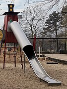
playground=slide
height=4
covered=yes
material=metalplayground=slide
height=3
incline=-56°
material=metalplayground=steps
step_count=9
material=wood
handrail=yesplayground=climbingframe
material=chainplayground=climbingframe
material=rope
height=1.2playground=climbingwall
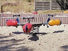
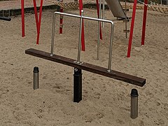
height=2playground=seesaw
capacity=3playground=seesaw
standing=yesplayground=structure
or playground=platform?
provided_for:toddler=yes
material=woodplayground=balance_rope
handrail:center=yesplayground=belt_bridge
capacity=3playground=spinner
seating=yesplayground=playhouse
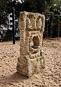
playground:theme=helicopterplayground=artwork
artwork:type=sculpture
material=sandstone


