Proposal:Inlets proposal
| Inlets proposal | |
|---|---|
| Proposal status: | Approved (active) |
| Proposed by: | fanfouer |
| Tagging: | inlet=* |
| Applies to: | |
| Definition: | Propose a new key to map culverts or pipeline inlets with details |
| Statistics: |
|
| Draft started: | 2020-12-13 |
| RFC start: | 2021-10-17 |
| Vote start: | 2021-12-14 |
| Vote end: | 2021-12-28 |
Inlets are key features in some water management infrastructure and have influence on how culverts or pipeline are operated.
They can be found in many places and can mark a limit between natural and artificial waterways. Some inlet features only allow liquids to pass through if a certain level is reached or if a certain nearby environmental or system condition is satisfied (such as overflow mode). Inlet features can also provide secondary function of filtering medium to large sized debris from the flow.
This proposal only focuses on liquids for sake of example comprehensiveness and it would be possible to extend it to gases in another document.
Proposal
It is proposed to use a new inlet=* key on nodes only to describe how a culvert or pipeline inlet is shaped or protected, whatever the liquid substance going through can be.
This new key will be defined as Shape or protection of a culvert, pipeline or duct intake.
This proposal only regards inlets or intakes shape where a liquid enters in a pipe or a machine. It doesn't restrict the proposed inlet=* key to liquids and may accept gases in a further document.
Outlets will be covered by another proposal as they have different functions as the fluid goes out of the pipe or culvert.
It will be possible to use proposed inlet=* in data validation process to legit the disappearance of a given dead-end waterway=* in an unknown underground duct.
Rationale
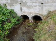
Inlets refer to punctual places where a fluid enters a pipe or a machine. It is suitable on OSM regarding tunnel=culvert, tunnel=flooded or man_made=pipeline whatever the substance flowing inside can be.
Mapping them is useful to know how solid matters (including waste) could be retained in ditches, rivers, storm drains or where water is took out of natural waterways.
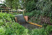
It's currently possible to look for artificial intakes with topological limits between different linear features. Mappers will often find screens, strainers or other solid retaining features there without available tagging to map them.
No substance on inlets
Proposed inlet=* is intended for the largest variety of fluids going through. OSM mappers are kindly invited to only tag inlets according to their own properties.
Knowledge of the fluid coming in is a matter for the pipe or tunnel network the inlet is a member of.
As a consequence, it is not recommended nor desired to reproduce values of substance=* or usage=* related to pipe on the inlet's node. Such data could easily be reproduced with pre-processing.
However, as there are situations where an inlet can be the only visible part of a larger underground infrastructure network that we are unable to map in OSM for various reasons, it would be possible to add substance=* on the inlet when mapped on a stand-alone node without be member of a tunnel or a pipeline way feature.
Tagging
Put a node at the junction between a culvert, pipeline and their upstream feature and use inlet=* to describe how this inlet is shaped.
| Key | Value | Comment |
|---|---|---|
| inlet=* | direct | The default inlet with no particular feature. The fluid goes directly downstream |
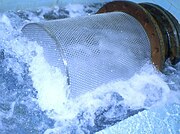
| screen | A large strainer or trash screen is installed to prevent solid matter, possibly waste, to go downstream | |
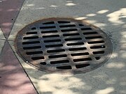
| grate | A simple and horizontal grate covers sumps on pavement or in a street to catch storm water | |
| kerb_opening | A wide opening is made on pavement kerbs on a road side to catch storm water | |
| kerb_grate | A wide opening is made on pavement kerbs and completed by an horizontal grate to catch storm water in a street. | |
| valve | A valve open or closes a pipeline or tunnel inlet to prevent the fluid to go downstream. | |
| bell_mouth | Bell mouth design allows to collect fluid coming from many directions, on a large spread and make it converge toward the duct entry like a funnel. | |
| yes | Any unspecified inlet |
Depending whether the inlet can be moved or opened, it is possible to use existing actuator=* or handle=* with it.
Depending on inlet dimension, it is also possible to complete with appropriate diameter=*, height=* ou width=*.
It may be useful, if known, to tag the nominal flow rate the inlet is designed for with flow_rate=*.
Edition management
Affected pages
- Create inlet=* page and proposed values pages
- Edit tunnel=* page and mention inlet=*
- Edit man_made=pipeline and mention inlet=*
Values to be replaced
No values are proposed for replacement in this proposal
Examples
Pipelines specific
| Photo | Location | Tagging | Comments |
|---|---|---|---|
 |
Belgium | A screen protects a downstream pipeline from debris coming with the bulk water it admits. |
See also
- Streets, inlets and storm drains documentation from Denver Mile High Flood District
- Inlet and Outlet Transitions for Canals and Culverts from Department of the Interior, Denver, Colorado
Voting
Voting on this proposal has been closed.
The result is appproved with 20 votes for, 1 vote against and 3 abstentions.
 I approve this proposal. --EneaSuper (talk) 12:34, 20 December 2021 (UTC)
 I approve this proposal. --GeoMechain (talk) 11:39, 14 December 2021 (UTC)
 I have comments but abstain from voting on this proposal. Can you clarify what should be used if there's a horizontal grate without a filter for the kerb opening? As in https://www.durham.com.au/gallery/kerb-entry-units/ vs Your example of inlet=kerb_grate having a narrow bar in the middle (hardly visible). ---- Kovposch (talk) 12:59, 14 December 2021 (UTC)
 I approve this proposal. looks great, I admit I do not map this kind of detail so far, but it seems you have created a proposal that could be used if someone maps these ;-) --Dieterdreist (talk) 14:57, 14 December 2021 (UTC)
 I approve this proposal. --Kaitu (talk) 14:58, 14 December 2021 (UTC)
 I approve this proposal. Clear and simple; I like it. --Penegal (talk) 16:42, 14 December 2021 (UTC)
 I have comments but abstain from voting on this proposal. Not enthusiastic about mapping all storm water grates like https://wiki.openstreetmap.org/wiki/File:Curb_gutter_storm_drain.JPG Mateusz Konieczny (talk) 17:02, 14 December 2021 (UTC)
 I approve this proposal. --Fizzie41 (talk) 22:01, 14 December 2021 (UTC)
 I approve this proposal. --Fanfouer (talk) 22:19, 14 December 2021 (UTC)
 I approve this proposal. --Rskedgell (talk) 22:57, 14 December 2021 (UTC)
 I approve this proposal. --Eginhard (talk) 19:51, 15 December 2021 (UTC)
 I approve this proposal. --Luschi (talk) 19:59, 15 December 2021 (UTC)
 I approve this proposal. --Dr Centerline (talk) 23:48, 15 December 2021 (UTC)
 I approve this proposal. --Bert Araali (talk) 17:35, 17 December 2021 (UTC)
 I oppose this proposal. In its current state I don't see the use cases this tagging is meant to serve. It appears to simply allow mappers to add various small features that are more or less related to drain water management to the database. That's fine in the sense that it channels (sic! ;) mappers into using consistent tags but from a data user point of view I am a bit puzzled how this helps anybody. The values don't make a lot of sense to me as they are overly specific without a good reason. That's especially true for a proposal that advertises its extensibility towards other uses than (drain) water. Apparently strainers are mapped according to their orientation and shape: horizontal=grates, vertical-ish=screen. The kerb-specific values are unnecessary because they should be attached to a barrier=kerb and could use the direct or strainer-specific value. The bell_mouth value is technically OK but from an internationalization standpoint I think something like funnel would be way easier to understand for non-native speakers and would be more generically applicable (which might not be desirable though). The most important property beside its physical appearance is missing: when is it active - always, by design in overflow conditions, after mechanical intervention (manually or by some sensor/actuator control)? The proposal also focus only on closed water infrastructure. I know many cases where strainers are installed in open canals for agricultural use or in alpine streams (for protection known as torrent control or in German: Wildbachverbauung, e.g., https://gastein-im-bild.info/eb/esbwko2.html) - as of now I would interpret the proposal text to not apply to open streams. *If* they would apply then there is clearly an overlap with waterway=lock_gate and waterway=sluice_gate that should be addressed: is it a gate or an inlet=valve or both? :) And the valve value has another problem/overlap that was not mentioned in the proposal: pipeline=valve. It might make more sense to split this proposal into values related/attached to pipeline=*, waterway=*, highway=* (or maybe barrier=*) keys IMHO. Needless to say: I should have brought these up earlier. It always feels bad to raise dust in the supposedly last step of the proposal process, sorry! --Stefanct (talk) 11:14, 18 December 2021 (UTC)
- No problem with comments, thank you. I've added your points in Talk page as to go on discussing Fanfouer (talk) 20:47, 19 December 2021 (UTC)
 I approve this proposal. --Atarom (talk) 12:23, 19 December 2021 (UTC)
 I approve this proposal. --JacquesLavignotte (talk) 13:32, 19 December 2021 (UTC)
 I approve this proposal. --Fnordson (talk) 14:26, 19 December 2021 (UTC)
 I have comments but abstain from voting on this proposal. I also feel this is too detailed and of questionable global value. I certainly hope, that if this is adopted I do not start getting warnings about a culvert not having one or both end nodes tagged. I certainly will not spend my valuable mapping time using this tagging scheme for any of the millions of curb inlets in streets --Rjgambrel (talk) 15:04, 19 December 2021 (UTC)
 I approve this proposal. --Waldhans (talk) 16:32, 19 December 2021 (UTC)
 I approve this proposal. --Reino Baptista (talk) 16:55, 19 December 2021 (UTC)
 I approve this proposal. --Nw520 (talk) 01:04, 20 December 2021 (UTC)
 I approve this proposal. --Adiatmad (talk) 01:04, 20 December 2021 (UTC)
 I approve this proposal. --Thetornado76 (talk) 05:42, 20 December 2021 (UTC)


