Proposal:Landuse=open defecation
Proposal
Open Defecation is still used by a large number of people throughout the world. In rural areas this can result in the spread of multiple pathogens and parasites. In urban areas underfunded sanitation services result in large piles of human rubbish, faeces and urine. When cleared Open Defecation Areas reappear due to lack of replacement sanitation facilities such as toilets. Areas can be large or small. When desperate people will find small locations that then are used by others for the same purpose. Locations of Open Defecation areas can be mapped as a point(node) or when very large as an area. OpenStreetMap always maps what is on the ground, these areas exist and should be mapped
Rationale
There are approximately 800 million people on earth that practice Open Defecation. Most often used in rural areas but importantly used in suburban areas and slums due to lack of coordinated community waste management. This is recognised as a serious health risk, especially for young children. If the faeces is not able to decompose then the buildup human faeces and other human waste products like plastic become a more dangerous mixture.
History: Broad Street Pump
The Broad Street Cholera outbreak of 1854 was the first use of a map to identify the source of cholera epidemic. Openstreetmap can use the same lesson used in 1854 to help prevent disease outbreaks world wide.
Present
Allowing people to get access to clean toilets is part of the UN Sustainable Development Goals 6.2 as part of their UN Sustainable development Goals. This feature will allow people to map areas where people are Open Defecating. The biggest problem is in India but there are many other countries that have the same problem especially in slums and refugee camps where there are no facilities. Many modern cities in first world countries also have a regular problem although on a much smaller scale and is usually an indication of other social problems.
Future
A map of Open Defecation areas will enable local community leaders to analyse and plan their area to provide greater sanitation. A picture representing the prevelence of Open Defecation can be seen in this image https://worldmapper.org/maps/housing-urbanopendefecation-2015/
Examples
Examples of Open Defecation can be found by searching google images using "Open Defecation slums"
Tagging
landuse=open_defecation as an area or node. An area of land that has informally been decided by the local community as a place to go to the toilet and has persisted for an extended period of time. The area usually contains a large assortment of rubbish but the waste of greatest concern is the human waste
landcover=open_defecation has been suggested:see Landcover However most places that have Open Defecation contain more than just human waste. landcover=mixed_waste would be more appropriate. landuse=waste, plus landcover=mixed_waste, plus open_defecation=yes could be a good evolutionary path for tagging this type of area because it deals with more complex types of waste
An insight from Map Kibera is here
Applies to
Areas or locations that are used for human Open Defecation. These are very varied. Any unmanaged space that lacks sanitation can easily become an Open Defecation Area
Rendering
Taking inspiration from the Amenity_toilet.svg I made a squatting person SVG
| Open Defecation 800x800 SVG | |
| landuse=open_defecation 20x20 png |
Rendering can be an node or an area, preferences are up to style sheet creators so as not to clash with their priorities
Rendering on the map
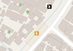
This icon can be rendered as a single spot for small areas or areas along a railway or waterway. Larger areas can be hatched. I used the black to make it stand out or the brown to not be so obtrusive
Features/Pages affected
OpenStreetMap does not use abbreviations such as ODA (open defecation area) or OD Open Defecation however compatible tags are
The key survey:date is used to indicate the date when a node, way or relation was last surveyed or verified in person.
The key source:date=* can be used to to show if the area was surveyed by people on the ground or from satellite imagery and verified by people on the ground
External discussions
There are many large international organisations including United Nations, World bank, Red Cross, Indian and Nigerian Government are discussing Open Defecation None of them have a map of where these areas are
Restarted 4/2/2021
Comments
Please comment on the discussion page.


